Lord Howe Island Airport
Lord Howe Island Airport (IATA: LDH[2], ICAO: YLHI) is an airport providing air transportation to Lord Howe Island.[1] Lord Howe Island is located in the Tasman Sea, 600 km (370 mi) east of Port Macquarie on the coast of mainland Australia. The airport is operated by the Lord Howe Island Board.[1]
Lord Howe Island Airport | |||||||||||
|---|---|---|---|---|---|---|---|---|---|---|---|
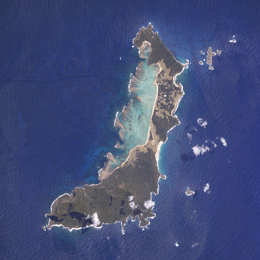 NASA image of Lord Howe Island | |||||||||||
| Summary | |||||||||||
| Airport type | Public | ||||||||||
| Operator | Lord Howe Island Board | ||||||||||
| Serves | Lord Howe Island, New South Wales, Australia | ||||||||||
| Elevation AMSL | 17 ft / 5 m | ||||||||||
| Coordinates | 31°32′18″S 159°04′38″E | ||||||||||
| Map | |||||||||||
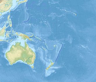 YLHI Location on map of Oceania | |||||||||||
| Runways | |||||||||||
| |||||||||||
Light aircraft transit
Lord Howe Island (along with Norfolk Island) is an important transit and refueling point for light aircraft flying between Australia and New Zealand. Located 600 km (373 mi) to the west is the Australian mainland, and 900 km (559 mi) to the east is Norfolk Island Airport which is within range of New Zealand to the southeast and New Caledonia to the north. These countries are within the range of many light aircraft when fitted with extra fuel tanks and operating via the two islands, but not while flying directly between them. From New Caledonia, other Pacific nations such as Vanuatu and Fiji are within range and can be used as further 'stepping stones' to other South Pacific and North Pacific destinations.
Facilities
The airport's elevation above mean sea level is 17 ft (5 m) and it has one runway, measuring 886 m × 30 m (2,907 ft × 98 ft).[1]
Airlines and destinations
| Airlines | Destinations |
|---|---|
| QantasLink | Brisbane, Sydney Seasonal: Port Macquarie |
Statistics
.jpg)
Lord Howe Island Airport served 33,385 revenue passengers during financial year[3] 2009-2010,[4] ranking it 64th amongst airports in Australia.
| Year[3] | Revenue passengers | Aircraft movements |
|---|---|---|
| 2001-02 | 25,674 | 1,014 |
| 2002-03 | 25,605 | 1,046 |
| 2003-04 | 26,647 | 1,063 |
| 2004-05 | 26,769 | 1,099 |
| 2005-06 | 30,736 | 1,219 |
| 2006-07 | 32,454 | 1,250 |
| 2007-08 | 34,736 | 1,302 |
| 2008-09 | 33,442 | 1,276 |
| 2009-10 | 33,385 | 1,245 |
| 2010-11 | 31,569 | 1,247 |
See also
References
- YLHI – Lord Howe Island (PDF). AIP En Route Supplement from Airservices Australia, effective 21 May 2020, Aeronautical Chart
- Airport information for Lord Howe Island, New South Wales, Australia (LDH / YLHI) at Great Circle Mapper.
- Fiscal year 1 July - 30 June
- "Airport Traffic Data 1985-86 to 2010-11". Bureau of Infrastructure, Transport and Regional Economics (BITRE). May 2012. Archived from the original on 24 March 2012. Retrieved 8 May 2012. Refers to "Regular Public Transport (RPT) operations only"