List of listed buildings in Livingston, West Lothian
This is a list of listed buildings in the parish of Livingston in West Lothian, Scotland.

Livingston parish shown within West Lothian
List
| Name | Location | Date Listed | Grid Ref. [note 1] | Geo-coordinates | Notes | LB Number [note 2] | Image |
|---|---|---|---|---|---|---|---|
| Auchenhard Tower | 55°51′01″N 3°36′24″W | Category B | 13648 |  | |||
| Blackburn Village Bridge, River Almond | 55°52′14″N 3°37′25″W | Category B | 7420 | | |||
| Livingston Mill Farm | 55°53′06″N 3°32′52″W | Category B | 7421 | | |||
| Bloom Cottage No 1 ;The Shop; Livingston Inn Cottages Nos 1 And 2, 4,4B; 6 And 8 Main Street | 55°53′09″N 3°32′21″W | Category C(S) | 7422 | | |||
| Auchenhard House Including Summerhouse And Gatepiers | 55°51′05″N 3°36′19″W | Category B | 49089 | | |||
| Livingston Village, Livingston Parish Kirk | 55°53′08″N 3°32′27″W | Category B | 7409 | 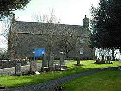 | |||
| Bloom Cottage 3 And 5 Main Street | 55°53′08″N 3°32′23″W | Category C(S) | 7412 | | |||
| Moss Houses | 55°54′29″N 3°31′26″W | Category B | 7417 | | |||
| Livingston Inn | 55°53′08″N 3°32′23″W | Category B | 7413 | | |||
| Livingston Bridge, River Almond | 55°53′05″N 3°32′21″W | Category B | 7414 | | |||
| Old Toll-House, Long Livingston | 55°53′13″N 3°33′32″W | Category B | 7415 | | |||
| Morven And Adjoining Heather Cottage 19 And 21 Main Street | 55°53′08″N 3°32′19″W | Category C(S) | 7405 | | |||
| 5 Houses. Known As The Old School House And The Danders, 1 Main Street | 55°53′08″N 3°32′23″W | Category C(S) | 7411 | | |||
| Newyearfield Farmhouse And Steading | 55°53′56″N 3°31′58″W | Category B | 7418 | | |||
| Auchenhard Farmhouse Including Boundary Wall And Gatepiers | 55°51′06″N 3°36′20″W | Category B | 49185 | | |||
| Livingston Manse | 55°53′07″N 3°32′26″W | Category B | 7410 | | |||
| Knightsridge House | 55°54′47″N 3°32′05″W | Category B | 7416 | | |||
| Blackburn House | 55°52′24″N 3°35′54″W | Category A | 7419 | 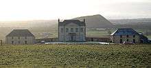 | |||
| "Bezu" 11 Main Street | 55°53′08″N 3°32′20″W | Category C(S) | 7407 | | |||
| Alderston Cottage Or Bloom Cottage Nos 2, 7 And 9 Main Street | 55°53′08″N 3°32′21″W | Category C(S) | 7408 | | |||
| Almond Bank (J H Shields) With Sub Post Office, Main Street | 55°53′08″N 3°32′19″W | Category C(S) | 7406 | |
Key
The scheme for classifying buildings in Scotland is:
- Category A: "buildings of national or international importance, either architectural or historic; or fine, little-altered examples of some particular period, style or building type."[1]
- Category B: "buildings of regional or more than local importance; or major examples of some particular period, style or building type, which may have been altered."[1]
- Category C: "buildings of local importance; lesser examples of any period, style, or building type, as originally constructed or moderately altered; and simple traditional buildings which group well with other listed buildings."[1]
In March 2016 there were 47,288 listed buildings in Scotland. Of these, 8% were Category A, and 50% were Category B, with the remaining 42% being Category C.[2]
Notes
- Sometimes known as OSGB36, the grid reference (where provided) is based on the British national grid reference system used by the Ordnance Survey.
• "Guide to National Grid". Ordnance Survey. Retrieved 2007-12-12.
• "Get-a-map". Ordnance Survey. Retrieved 2007-12-17. - Historic Environment Scotland assign a unique alphanumeric identifier to each designated site in Scotland, for listed buildings this always begins with "LB", for example "LB12345".
gollark: Being dead would upset the osmarks.tk development roadmap.
gollark: Fine. You are declared bees. Bye.
gollark: ···
gollark: No, the adult there already exists.
gollark: If you think about it, maybe OTHER people want to keep living.
References
- All entries, addresses and coordinates are based on data from Historic Scotland. This data falls under the Open Government Licence
- "What is Listing?". Historic Environment Scotland. Retrieved 29 May 2018.
- Scotland's Historic Environment Audit 2016 (PDF). Historic Environment Scotland and the Built Environment Forum Scotland. pp. 15–16. Retrieved 29 May 2018.
This article is issued from Wikipedia. The text is licensed under Creative Commons - Attribution - Sharealike. Additional terms may apply for the media files.