List of listed buildings in Linlithgow, West Lothian
This is a list of listed buildings in the parish of Linlithgow in West Lothian, Scotland.

Linlithgow parish shown within West Lothian
List
| Name | Location | Date Listed | Grid Ref. [note 1] | Geo-coordinates | Notes | LB Number [note 2] | Image |
|---|---|---|---|---|---|---|---|
| 26, 28 High Street | 55°58′37″N 3°35′50″W | Category C(S) | 37435 |  | |||
| 74, 76 High Street | 55°58′37″N 3°35′56″W | Category C(S) | 37446 | | |||
| Linlithgow Palace, Gate-House | 55°58′41″N 3°36′03″W | Category A | 37470 | 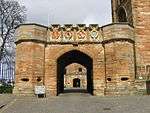 | |||
| 19 Lion Well Wynd And Boundary Wall | 55°58′32″N 3°36′15″W | Category C(S) | 37475 | | |||
| 2 Royal Terrace | 55°58′31″N 3°36′11″W | Category C(S) | 37491 | | |||
| Edinburgh Road, St Magdalene's Distillery East Barns | 55°58′36″N 3°35′27″W | Category C(S) | 37370 | | |||
| Friarsbrae, Rivaldsgreen House With Gatepiers And Boundary Walls | 55°58′21″N 3°36′11″W | Category B | 37377 | | |||
| Friarsbrae, Victoria Place With Boundary Walls | 55°58′27″N 3°36′07″W | Category B | 37380 | | |||
| High Street, Court House | 55°58′35″N 3°36′05″W | Category B | 37400 |  | |||
| 103, 105 High Street | 55°58′35″N 3°36′07″W | Category C(S) | 37402 | | |||
| 169-173 (Odd Nos) High Street | 55°58′34″N 3°36′17″W | Category C(S) | 37417 | | |||
| 201,203, 205 High Street | 55°58′33″N 3°36′21″W | Category C(S) | 37420 | | |||
| 217-221 (Odd Nos) High Street | 55°58′33″N 3°36′22″W | Category C(S) | 37422 | | |||
| 293 High Street | 55°58′33″N 3°36′33″W | Category B | 37429 |  | |||
| 2, 4 High Street | 55°58′37″N 3°35′47″W | Category C(S) | 37432 | | |||
| Hiltly Farm With Gatepiers And Enclosing Walls | 55°57′42″N 3°35′43″W | Category B | 12975 | | |||
| Linlithgow Bridge, 2-14 (Even Nos) Main Street, Chalmers Cottages | 55°58′34″N 3°37′34″W | Category B | 12976 | | |||
| Preston House Lodge With Gates And Gatepiers | 55°57′59″N 3°36′18″W | Category B | 12984 | | |||
| Bonnytoun Cottages | 55°59′23″N 3°35′27″W | Category C(S) | 7470 | | |||
| Bridgend Farm | 55°58′08″N 3°32′04″W | Category B | 7472 | | |||
| Champfleurie Home Farm | 55°58′17″N 3°32′50″W | Category B | 7477 | | |||
| Champfleurie House With Lodge, Gatepiers And Boundary Wall | 55°58′14″N 3°32′51″W | Category B | 7478 | | |||
| Edinburgh Road Kingscavil Cottages, Including Former Schoolhouse | 55°58′18″N 3°33′20″W | Category A | 7482 |  | |||
| 36, 36A High Street | 55°58′37″N 3°35′51″W | Category B | 37437 |  | |||
| 50 High Street Red Lion Inn | 55°58′37″N 3°35′53″W | Category B | 37440 | | |||
| 100 High Street | 55°58′38″N 3°35′59″W | Category C(S) | 37450 | | |||
| 114 High Street | 55°58′38″N 3°36′00″W | Category C(S) | 37452 | | |||
| 232, 234 And 236 High Street | 55°58′34″N 3°36′19″W | Category B | 37459 |  | |||
| 2 Kirkgate | 55°58′39″N 3°36′04″W | Category B | 37463 | | |||
| Kirkgate, Walls | 55°58′40″N 3°36′03″W | Category B | 37467 | | |||
| Manse Road, Canal Basin, Cottages And Stables | 55°58′30″N 3°35′54″W | Category B | 37479 | | |||
| Manse Road Canal House With Gig House Gatepiers And Boundary Wall | 55°58′30″N 3°35′56″W | Category B | 37480 | | |||
| Manse Road, Edinburgh And Glasgow Union Canal Bridge 43 | 55°58′31″N 3°35′50″W | Category B | 37482 |  | |||
| 5 Union Road With Boundary Wall | 55°58′32″N 3°36′17″W | Category C(S) | 37502 | | |||
| 26 West Port | 55°58′34″N 3°36′43″W | Category C(S) | 37507 | | |||
| Bathgate Road, Ashley Hall | 55°58′30″N 3°36′42″W | Category B | 37355 | | |||
| 23 High Street | 55°58′36″N 3°35′51″W | Category C(S) | 37384 | | |||
| 49, 51 High Street | 55°58′36″N 3°35′56″W | Category B | 37389 |  | |||
| 63 High Street With Railings | 55°58′36″N 3°35′59″W | Category B | 37393 |  | |||
| 107, 109 High Street | 55°58′35″N 3°36′07″W | Category C(S) | 37403 | | |||
| 111, 113 High Street, Football And Cricketers Arms | 55°58′35″N 3°36′08″W | Category C(S) | 37404 | | |||
| 115 High Street, Football And Cricketers Arms | 55°58′35″N 3°36′08″W | Category C(S) | 37405 | | |||
| 129 High Street | 55°58′34″N 3°36′11″W | Category B | 37407 |  | |||
| 137-141 (Odd Nos) High Street | 55°58′33″N 3°36′12″W | Category C(S) | 37409 | | |||
| Grange House With Conservatory, Terrace Garden, Pavilions, Loggia And Sundial | 55°59′29″N 3°36′15″W | Category A | 12972 | | |||
| Linlithgow Bridge, Main Street, Public Hall (Community Centre) | 55°58′33″N 3°37′35″W | Category B | 12977 | | |||
| Woodcockdale, Edinburgh And Glasgow Union Canal Stables And Cottages | 55°57′54″N 3°38′32″W | Category A | 12989 | 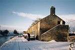 | |||
| Burghmuir Farmhouse And Steading With Horsemill | 55°59′06″N 3°34′10″W | Category C(S) | 7475 | | |||
| Easter Carribber Farmhouse And Steading | 55°57′26″N 3°39′05″W | Category B | 7481 | | |||
| Union Road, Railway Wall (To N Of Track) Including Rail Bridge To E | 55°58′33″N 3°36′02″W | Category C(S) | 46268 | | |||
| 70, 72 High Street | 55°58′37″N 3°35′55″W | Category C(S) | 37445 | | |||
| 212, 214 High Street | 55°58′35″N 3°36′16″W | Category B | 37453 |  | |||
| 246, 248 High Street | 55°58′34″N 3°36′21″W | Category C(S) | 37461 | | |||
| Kirkgate, Rosegarden, Statue Of 1St Marquess Of Linlithgow | 55°58′40″N 3°36′00″W | Category B | 37466 |  | |||
| 13 Lion Well Wynd | 55°58′33″N 3°36′15″W | Category B | 37473 | | |||
| The Maltings, Corner Mains Road And Moray Drive, Mains And Cottages | 55°58′21″N 3°37′15″W | Category C(S) | 37478 | | |||
| Manse Road, Clarendon House With Gatepiers, Boundary Walls, And Stables | 55°58′24″N 3°35′38″W | Category B | 37481 | | |||
| 7, 7A Royal Terrace With Coach House, Outbuildings, Gates, Gatepiers, Railings And Boundary Wall | 55°58′29″N 3°36′15″W | Category B | 37493 | | |||
| St Michael's Parish Church (Church Of Scotland) With Gateway And Livingston Burial Vault | 55°58′41″N 3°36′01″W | Category A | 37499 |  | |||
| Union Road, St John's Evangelical Church | 55°58′30″N 3°36′26″W | Category C(S) | 37505 | | |||
| 12, 14 West Port The Black Bitch Hotel | 55°58′33″N 3°36′40″W | Category C(S) | 37506 |  | |||
| Bonnytoun House With Walled Garden And Ornamental Stack | 55°59′08″N 3°35′11″W | Category B | 37360 | | |||
| Braehead, Edinburgh And Glasgow Union Canal Bridge 46 | 55°58′07″N 3°36′49″W | Category B | 37361 |  | |||
| 9-17 And 19-21 (Odd Nos) High Street | 55°58′36″N 3°35′49″W | Category B | 37382 |  | |||
| 69, 71 High Street | 55°58′36″N 3°36′00″W | Category C(S) | 37395 | | |||
| High Street, Police Station | 55°58′34″N 3°36′05″W | Category C(S) | 37401 |  | |||
| 123-127 (Odd Nos) High Street | 55°58′35″N 3°36′10″W | Category B | 37406 |  | |||
| 131-135 High Street | 55°58′34″N 3°36′11″W | Category B | 37408 |  | |||
| 143 High Street, Annet House | 55°58′34″N 3°36′12″W | Category B | 37410 |  | |||
| 149 High Street | 55°58′34″N 3°36′14″W | Category C(S) | 37413 | | |||
| High Street, St Peter`S (Episcopal) Church | 55°58′34″N 3°36′14″W | Category B | 37414 |  | |||
| 175 High Street | 55°58′34″N 3°36′17″W | Category C(S) | 37418 | | |||
| 263, 265 (Odd Nos) High Street | 55°58′33″N 3°36′28″W | Category B | 37425 |  | |||
| 10-18 (Even Nos) High Street | 55°58′37″N 3°35′48″W | Category C(S) | 37433 | | |||
| Gateside Steading | 55°57′56″N 3°31′28″W | Category B | 12971 |  | |||
| Williamcraigs House, Garden Pavilion And Gatepiers | 55°57′38″N 3°37′35″W | Category B | 12987 | | |||
| 20-24 (Even Nos) High Street | 55°58′37″N 3°35′50″W | Category B | 37434 | | |||
| 30-34 (Even Nos) High Street | 55°58′37″N 3°35′51″W | Category B | 37436 | | |||
| 52 And 54 High Street | 55°58′37″N 3°35′53″W | Category B | 37441 | | |||
| 82-86 (Even Nos) High Street | 55°58′37″N 3°35′57″W | Category C(S) | 37448 | | |||
| 222, 224 High Street | 55°58′35″N 3°36′17″W | Category C(S) | 37457 | | |||
| 238 High Street | 55°58′34″N 3°36′20″W | Category C(S) | 37460 | | |||
| 258, 260 High Street | 55°58′34″N 3°36′22″W | Category C(S) | 37462 | | |||
| Learmonth Gardens, Dovecot | 55°58′32″N 3°35′54″W | Category A | 37468 |  | |||
| Linlithgow Palace And Fountain | 55°58′43″N 3°36′03″W | Category A | 37469 | 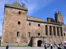 | |||
| Lion Well Wynd Walls | 55°58′33″N 3°36′16″W | Category C(S) | 37477 | | |||
| Manse Road, Friarbank With Gates, Gatepiers And Boundary Wall | 55°58′23″N 3°35′51″W | Category B | 37483 | | |||
| Manse Road, Nether Parkley | 55°58′21″N 3°35′54″W | Category B | 37485 | | |||
| Manse Road, Nether Parkley Lodge, Gatepiers And Boundary Walls | 55°58′19″N 3°35′51″W | Category B | 37486 | | |||
| Preston Road, Poldrait | 55°58′11″N 3°36′19″W | Category B | 37489 | | |||
| 13 Royal Terrace With Boundary Walls And Piers | 55°58′28″N 3°36′17″W | Category C(S) | 37496 | | |||
| 14 Royal Terrace With Boundary Walls And Piers | 55°58′29″N 3°36′18″W | Category B | 37497 | | |||
| St Michael's Wynd Rear 23 High Street | 55°58′35″N 3°35′51″W | Category C(S) | 37500 | | |||
| 4, 4A, 5, 5A Strawberry Bank | 55°58′31″N 3°36′08″W | Category C(S) | 37501 | | |||
| The Cross And Kirkgate, Burgh Halls (Former Town House And Old Country Hall) | 55°58′39″N 3°36′02″W | Category A | 37362 |  | |||
| 13, 14 The Cross | 55°58′38″N 3°36′00″W | Category C(S) | 37366 | | |||
| Edinburgh Road, Edinburgh And Glasgow Union Canal Aqueduct | 55°58′33″N 3°35′05″W | Category B | 37368 | | |||
| Falkirk Road, St Ninian's Craigmailen Church,Boundary Wall And Gatepiers | 55°58′34″N 3°36′49″W | Category B | 37373 | | |||
| Falkirk Road, Westerpark With Former Coach-House | 55°58′31″N 3°36′53″W | Category C(S) | 37374 | | |||
| Friarsbrae, Douglas Cottage (Former Douglas Cottage School) | 55°58′28″N 3°36′06″W | Category B | 37375 | | |||
| Friarsbrae, Rosemount | 55°58′27″N 3°36′04″W | Category B | 37379 | | |||
| 33-37 (Odd Nos) High Street | 55°58′36″N 3°35′54″W | Category C(S) | 37386 | | |||
| 65, 67 High Street, The Four Marys | 55°58′36″N 3°35′59″W | Category C(S) | 37394 |  | |||
| 161, 161C, 163 High Street | 55°58′34″N 3°36′16″W | Category C(S) | 37415 | | |||
| High Street, New Well | 55°58′33″N 3°36′25″W | Category C(S) | 37423 | | |||
| 303 To 313 And 315 And 325 (Odd Nos) High Street And Gateway | 55°58′32″N 3°36′38″W | Category B | 37431 |  | |||
| Ochiltree Castle & Castlegate (Former Ochiltree Place) With Boundary Wall | 55°57′22″N 3°33′03″W | Category A | 12978 | | |||
| Pardovan, Edinburgh And Glasgow Union Canal Bridge 40 | 55°58′36″N 3°32′21″W | Category B | 12979 | | |||
| Park, Edinburgh And Glasgow Union Canal Bridge 41 | 55°58′34″N 3°33′28″W | Category B | 12980 |  | |||
| Philipstoun Main Street Pardovan Church | 55°58′36″N 3°31′42″W | Category B | 12982 | | |||
| 48 Woodcockvale, Edinburgh And Glasgow Union Canal Bridge 48 | 55°57′52″N 3°38′42″W | Category B | 12988 | | |||
| Belsyde House With Lodge, Gatepiers And Boundary Walls | 55°57′41″N 3°38′39″W | Category B | 7469 | | |||
| Falkirk Road, Longcroft House | 55°58′40″N 3°37′02″W | Category B | 7483 | | |||
| Linlithgow Palace, Lodge | 55°58′41″N 3°36′05″W | Category C(S) | 37471 |  | |||
| Linlithgow Railway Station | 55°58′35″N 3°35′45″W | Category C(S) | 37472 |  | |||
| 17 Lion Well Wynd And Boundary Wall | 55°58′33″N 3°36′15″W | Category B | 37474 | | |||
| 10 And 11 Royal Terrace With Boundary Walls And Gatepiers | 55°58′30″N 3°36′16″W | Category B | 37495 | | |||
| Wilcoxholm, Edinburgh And Glasgow Union Canal Bridge 42 | 55°58′38″N 3°34′21″W | Category B | 37508 |  | |||
| 11 The Cross | 55°58′38″N 3°36′01″W | Category C(S) | 37364 | | |||
| The Cross, Cross Well With Pedestal And Commemorative Stone | 55°58′38″N 3°36′02″W | Category B | 37367 |  | |||
| Falkirk Road, Longcroft House Gatepiers And Boundary Wall | 55°58′33″N 3°36′47″W | Category C(S) | 37372 | | |||
| Friarsbrae, Edinburgh And Glasgow Union Canal Bridge 44 | 55°58′28″N 3°36′10″W | Category B | 37376 |  | |||
| Friarsbrae, Rivaldsgreen Coach House | 55°58′21″N 3°36′10″W | Category C(S) | 37378 | | |||
| 39,41 High Street | 55°58′36″N 3°35′54″W | Category B | 37387 |  | |||
| 43-47 (Odd Nos) High Street | 55°58′36″N 3°35′56″W | Category B | 37388 |  | |||
| High Street, County Buildings With Screen Wall Lamp Standards And Provost's Lamp | 55°58′35″N 3°36′03″W | Category B | 37399 |  | |||
| 213, 215 High Street | 55°58′33″N 3°36′21″W | Category B | 37421 |  | |||
| 297, 299 High Street, West Port House With Retaining Walls | 55°58′33″N 3°36′34″W | Category A | 37430 |  | |||
| Grange House Stables And Cottage | 55°59′32″N 3°36′17″W | Category C(S) | 12973 | | |||
| Wairdlaw Lime Kilns | 55°56′24″N 3°36′36″W | Category B | 12986 | | |||
| Avon Aqueduct, Edinburgh And Glasgow Union Canal Aqueduct | 55°57′51″N 3°39′22″W | Category A | 7468 | | |||
| Burgh Mill Lane, Burgh Mill House And Adjoining Outbuilding | 55°58′29″N 3°37′52″W | Category C(S) | 7474 | | |||
| Cauldhame Farmhouse,Steading And Horsemill | 55°57′42″N 3°34′59″W | Category B | 7476 | | |||
| 259, 261 High Street | 55°58′33″N 3°36′28″W | Category B | 47560 |  | |||
| 78, 80 High Street | 55°58′37″N 3°35′56″W | Category B | 37447 | | |||
| 3 Kirkgate | 55°58′39″N 3°36′04″W | Category B | 37464 |  | |||
| Blackness Road, St Michael's Church And Presbytery (Roman Catholic) | 55°58′44″N 3°35′41″W | Category B | 37359 |  | |||
| 12 The Cross | 55°58′38″N 3°36′01″W | Category C(S) | 37365 | | |||
| Edinburgh Road, Rosebank | 55°58′35″N 3°35′10″W | Category C(S) | 37369 | | |||
| High Street, St Michael's Well | 55°58′36″N 3°35′51″W | Category A | 37383 |  | |||
| 29, 31 High Street Post Office | 55°58′35″N 3°35′52″W | Category B | 37385 |  | |||
| 89, 91 High Street | 55°58′37″N 3°36′02″W | Category B | 37398 |  | |||
| 145 High Street | 55°58′34″N 3°36′13″W | Category C(S) | 37411 | | |||
| 257 High Street | 55°58′33″N 3°36′28″W | Category B | 37424 |  | |||
| 275 High Street And 18, 20 St John's Avenue | 55°58′33″N 3°36′30″W | Category B | 37428 |  | |||
| Grange House, Walled Garden | 55°59′27″N 3°36′24″W | Category C(S) | 12974 | | |||
| Airngarth Hill, Hope Monument | 55°59′37″N 3°36′00″W | Category B | 7467 | | |||
| Bonnytoun Home Farm And Adjoining Steading | 55°59′15″N 3°35′28″W | Category B | 7471 | | |||
| East Belsyde, Edinburgh And Glasgow Union Canal Bridge 47 | 55°58′01″N 3°38′14″W | Category B | 7480 |  | |||
| 56-60 (Even Nos) High Street | 55°58′37″N 3°35′53″W | Category C(S) | 37442 | | |||
| 62, 64 High Street | 55°58′37″N 3°35′54″W | Category C(S) | 37443 | | |||
| 212, 214 Rear High Street, Former Tannery | 55°58′36″N 3°36′16″W | Category C(S) | 37454 | | |||
| 220 High Street | 55°58′35″N 3°36′17″W | Category C(S) | 37456 | | |||
| High Street, Baird Hall | 55°58′34″N 3°36′18″W | Category C(S) | 37458 | | |||
| Kirkgate And The Cross, Burgh Halls (Former Town House And Old County Hall) | 55°58′39″N 3°36′02″W | Category B | 37465 | | |||
| 16 Lion Well Wynd And Boundary Wall | 55°58′32″N 3°36′16″W | Category C(S) | 37476 | | |||
| Manse Road, Glebe House, Former Linlithgow Manse With Gatepiers And Boundary Wall | 55°58′10″N 3°35′48″W | Category B | 37484 | | |||
| 1 Royal Terrace With Boundary Wall | 55°58′31″N 3°36′10″W | Category C(S) | 37490 | | |||
| 6 Royal Terrace | 55°58′30″N 3°36′13″W | Category B | 37492 | | |||
| 8, 9 Royal Terrace With Boundary Walls And Gatepiers | 55°58′30″N 3°36′15″W | Category B | 37494 | | |||
| Union Road, Lindisfarne With Boundary Walls And Gate | 55°58′30″N 3°36′27″W | Category B | 37504 | | |||
| Bell's Burn, Baron's Hill | 55°58′43″N 3°35′33″W | Category B | 37356 | | |||
| 57, 59 High Street | 55°58′36″N 3°35′58″W | Category C(S) | 37391 | | |||
| 147 High Street | 55°58′34″N 3°36′13″W | Category C(S) | 37412 | | |||
| 165 High Street | 55°58′34″N 3°36′16″W | Category B | 37416 |  | |||
| 177, 179 (Odd Nos) High Street The Crown Arms | 55°58′33″N 3°36′18″W | Category B | 37419 |  | |||
| Philipstoun, Edinburgh And Glasgow Union Canal Aqueduct | 55°58′32″N 3°31′30″W | Category B | 12981 | | |||
| Preston House Including Screen Wall And Coach Archway | 55°57′54″N 3°36′37″W | Category A | 12983 | | |||
| 38-44 (Even Nos) High Street, Hamilton's Land | 55°58′37″N 3°35′52″W | Category A | 37438 | 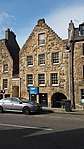 | |||
| 46, 48 High Street, Hamiltons' Land | 55°58′37″N 3°35′52″W | Category A | 37439 | | |||
| 66, 68 High Street | 55°58′37″N 3°35′54″W | Category C(S) | 37444 | | |||
| 96, 98 High Street | 55°58′38″N 3°35′58″W | Category C(S) | 37449 | | |||
| 102, 104 High Street | 55°58′38″N 3°35′59″W | Category C(S) | 37451 | | |||
| 216, 218 High Street | 55°58′35″N 3°36′16″W | Category C(S) | 37455 | | |||
| Market Lane, Masonic Lodge Of Linlithgow | 55°58′39″N 3°36′01″W | Category C(S) | 37487 |  | |||
| 1-3 (Odd Nos) Preston Road | 55°58′32″N 3°36′39″W | Category B | 37488 | | |||
| 20 Royal Terrace With Retaining Wall And Railings | 55°58′29″N 3°36′23″W | Category C(S) | 37498 | | |||
| 6 Union Road And Lion Well Wynd | 55°58′31″N 3°36′16″W | Category C(S) | 37503 | | |||
| Back Station Road, Edinburgh And Glasgow Union Canal Aqueduct | 55°58′33″N 3°35′42″W | Category B | 37354 | | |||
| Blackness Road, Boghall Lodge | 55°59′03″N 3°34′48″W | Category B | 37357 | | |||
| Blackness Road, Low Port Primary School, (Former Linlithgow Academy) | 55°58′42″N 3°35′48″W | Category B | 37358 |  | |||
| 5 The Cross, Cross House | 55°58′38″N 3°36′04″W | Category A | 37363 |  | |||
| Edinburgh Road, St Magdalene's Distillery Malting Barn And Double Kiln | 55°58′35″N 3°35′33″W | Category C(S) | 37371 |  | |||
| 1 High Street, The Star And Garter Hotel | 55°58′37″N 3°35′47″W | Category B | 37381 |  | |||
| 53, 55 High Street With Gateways, Gatepiers, Gates And Railings The Royal Bank Of Scotland | 55°58′36″N 3°35′57″W | Category B | 37390 |  | |||
| 61 High Street | 55°58′36″N 3°35′58″W | Category C(S) | 37392 | | |||
| 73,75 High Street | 55°58′36″N 3°36′00″W | Category C(S) | 37396 | | |||
| 77, 79 High Street | 55°58′37″N 3°36′01″W | Category C(S) | 37397 | | |||
| 267, 269 High Street | 55°58′33″N 3°36′29″W | Category C(S) | 37426 | | |||
| 271, 273 High Street The Portcullis | 55°58′33″N 3°36′29″W | Category C(S) | 37427 | | |||
| Gateside Farmhouse With Gig-House And Boundary Wall | 55°57′56″N 3°31′26″W | Category C(S) | 12970 | | |||
| River Avon, Edinburgh To Glasgow Railway Viaduct | 55°58′29″N 3°38′00″W | Category A | 12985 | 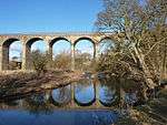 | |||
| Bridgend Farmhouse | 55°58′09″N 3°32′00″W | Category B | 7473 | |
Key
The scheme for classifying buildings in Scotland is:
- Category A: "buildings of national or international importance, either architectural or historic; or fine, little-altered examples of some particular period, style or building type."[1]
- Category B: "buildings of regional or more than local importance; or major examples of some particular period, style or building type, which may have been altered."[1]
- Category C: "buildings of local importance; lesser examples of any period, style, or building type, as originally constructed or moderately altered; and simple traditional buildings which group well with other listed buildings."[1]
In March 2016 there were 47,288 listed buildings in Scotland. Of these, 8% were Category A, and 50% were Category B, with the remaining 42% being Category C.[2]
Notes
- Sometimes known as OSGB36, the grid reference (where provided) is based on the British national grid reference system used by the Ordnance Survey.
• "Guide to National Grid". Ordnance Survey. Retrieved 12 December 2007.
• "Get-a-map". Ordnance Survey. Retrieved 17 December 2007. - Historic Environment Scotland assign a unique alphanumeric identifier to each designated site in Scotland, for listed buildings this always begins with "LB", for example "LB12345".
References
- All entries, addresses and coordinates are based on data from Historic Scotland. This data falls under the Open Government Licence
- "What is Listing?". Historic Environment Scotland. Retrieved 29 May 2018.
- Scotland's Historic Environment Audit 2016 (PDF). Historic Environment Scotland and the Built Environment Forum Scotland. pp. 15–16. Retrieved 29 May 2018.
This article is issued from Wikipedia. The text is licensed under Creative Commons - Attribution - Sharealike. Additional terms may apply for the media files.