Linganore Creek
Linganore Creek is a 13.5-mile-long (21.7 km)[1] tributary of the Monocacy River in Frederick County, Maryland. The stream is formed from the confluence of the north and south forks of the Linganore (39.4489911°N 77.2216489°W), about 10 miles (16 km) east-northeast of the city of Frederick. The creek runs roughly southwest to the Monocacy River, which drains to the Potomac River. The watershed area of the creek is 83.1 square miles (215 km2). High water in the creek can result in flooding of Gas House Pike, an east-west road running between Monocacy Boulevard and Green Valley Road.[2]
| Linganore Creek | |
|---|---|
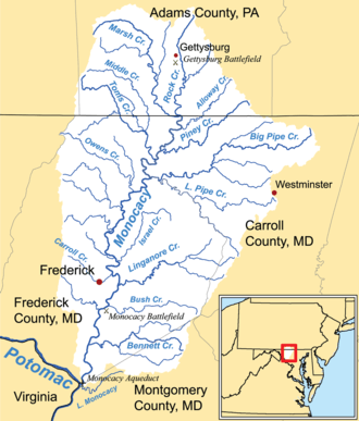 Watershed map showing Linganore Creek | |
| Location | |
| Country | United States |
| State | Maryland |
| Region | Western Maryland |
| Cities | Frederick, New Market, Mount Airy |
| Physical characteristics | |
| Source | |
| • location | Church Creek, Maryland |
| Mouth | Monocacy River |
• location | Frederick, MD |
• elevation | 0 ft (0 m) |
| Basin features | |
| Tributaries | |
| • left | Bens Branch, Spicer Creek, North Fork Linganore Creek |
| • right | Town Branch, Dollyhyde Creek, South Fork Linganore Creek |
The name "linganore" purportedly means "left ear" (of the Potomac), a name coined by an American Indian chief who once lived on the banks of the waterway.[3][4]
Lake Linganore
Lake Linganore, an impoundment built on the creek about 4 miles (6 km) east of Frederick, is the principal source of drinking water for the city. It is also a drinking water source for the central portion of Frederick County.[5][6] The community of Lake Linganore takes its name from the lake.
See also
- List of Maryland rivers
References
- U.S. Geological Survey. National Hydrography Dataset high-resolution flowline data. The National Map Archived 2012-04-05 at WebCite, accessed August 15, 2011
- Staff (17 May 2014). "Eight rescued from rising water, numerous road closures reported as a result of flash flooding". Frederick News-Post.
- Williams, Thomas John Chew; McKinsey, Folger (1967) [1910]. History of Frederick County, Maryland. 1 (reprint ed.). Genealogical Publishing Company. p. 326. ISBN 9780806379739 – via Google Books.
- Scharf, John Thomas (2003) [1882]. History of Western Maryland. 1 (reprint ed.). Genealogical Publishing Company. p. 605. ISBN 9780806345659 – via Google Books.
- Metropolitan Washington Council of Governments. Washington, DC. " Metropolitan Washington Region Water Supply Agencies" Accessed May 6, 2008.
- Maryland Department of the Environment. Baltimore, MD. "Source Water Assessment for Lake Linganore Water Treatment Plant, Frederick County." April 2005.
External links
- Lake Linganore Source Water Protection Plan – Frederick County
- Lower Linganore Creek Stream Corridor Assessment Survey (2005) – Maryland Department of Natural Resources & Frederick County
- Action Plan for the Linganore Source Water Protection Plan - Frederick County
- Monocacy & Catoctin Watershed Alliance
Coordinates
| Feature | Coordinates |
|---|---|
| Linganore Creek | 39.407325°N 77.365263°W |
| Lake Linganore | 39.4143954°N 77.2943722°W |
| confluence of the north and south forks of the Linganore | 39.4489911°N 77.2216489°W |