Levan, Utah
Levan (/ləˈvæn/ lə-VAN) is a town in Juab County, Utah, United States. As of the 2010 census it had a population of 841,[5] and in 2018 the estimated population was 924 (an eight year increase of 9.9%).[6]
Levan, Utah | |
|---|---|
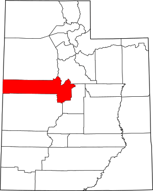
 Location in Juab County and the state of Utah | |
| Coordinates: 39°33′24″N 111°51′40″W | |
| Country | United States |
| State | Utah |
| County | Juab |
| Founded | 1867 |
| Area | |
| • Total | 0.81 sq mi (2.10 km2) |
| • Land | 0.81 sq mi (2.10 km2) |
| • Water | 0.00 sq mi (0.00 km2) |
| Elevation | 5,315 ft (1,620 m) |
| Population (2010) | |
| • Total | 841 |
| • Estimate (2019)[2] | 954 |
| • Density | 1,177.78/sq mi (454.79/km2) |
| Time zone | UTC-7 (Mountain (MST)) |
| • Summer (DST) | UTC-6 (MDT) |
| ZIP code | 84639 |
| Area code(s) | 435 |
| FIPS code | 49-44650[3] |
| GNIS feature ID | 1442564[4] |
| Website | levantown |
It is often said that the name of the town derives from its location at the center of Utah, because the name is "navel" spelled backwards.[7] Several other origins have been suggested for the name, from French, Latin, or Colorado River Numic language.[8]
Geography
Levan is in eastern Juab County, in the Juab Valley at the western base of the San Pitch Mountains. Utah State Route 28 passes through the town, leading north 10 miles (16 km) to Nephi, the county seat, and south 30 miles (48 km) to Gunnison. Utah State Route 78 leads southwest from Levan 11 miles (18 km) to Interstate 15 near Chicken Creek Reservoir.
According to the United States Census Bureau, Levan has a total area of 0.77 square miles (2.0 km2), all of it land.[5]
Climate
This climatic region is typified by large seasonal temperature differences, with warm to hot (and often humid) summers and cold (sometimes severely cold) winters. According to the Köppen Climate Classification system, Levan has a humid continental climate, abbreviated "Dfb" on climate maps.
Demographics
| Historical population | |||
|---|---|---|---|
| Census | Pop. | %± | |
| 1900 | 614 | — | |
| 1910 | 752 | 22.5% | |
| 1920 | 634 | −15.7% | |
| 1930 | 611 | −3.6% | |
| 1940 | 621 | 1.6% | |
| 1950 | 521 | −16.1% | |
| 1960 | 421 | −19.2% | |
| 1970 | 376 | −10.7% | |
| 1980 | 453 | 20.5% | |
| 1990 | 416 | −8.2% | |
| 2000 | 688 | 65.4% | |
| 2010 | 841 | 22.2% | |
| Est. 2019 | 954 | [2] | 13.4% |
| U.S. Decennial Census[9] | |||
As of the census[3] of 2000, there were 688 people, 219 households, and 183 families residing in the town. The population density was 900.7 people per square mile (349.5/km2). There were 258 housing units at an average density of 337.7 per square mile (131.1/km2). The racial makeup of the town was 97.38% White, 0.15% African American, 0.15% Native American, 0.29% Pacific Islander, 0.15% from other races, and 1.89% from two or more races. 3.49% of the population were Hispanic or Latino of any race.
There were 219 households, out of which 49.8% had children under the age of 18 living with them, 69.4% were married couples living together, 10.5% had a female householder with no husband present, and 16.0% were non-families. 15.1% of all households were made up of individuals, and 6.8% had someone living alone who was 65 years of age or older. The average household size was 3.14 and the average family size was 3.49.
In the town, the population was spread out, with 37.2% under the age of 18, 8.4% from 18 to 24, 26.3% from 25 to 44, 17.3% from 45 to 64, and 10.8% who were 65 years of age or older. The median age was 28 years. For every 100 females, there were 103.6 males. For every 100 females age 18 and over, there were 96.4 males.
The median income for a household in the town was $34,632, and the median income for a family was $36,250. Males had a median income of $33,500 versus $18,750 for females. The per capita income for the town was $12,260. 6.1% of the population and 5.1% of families were below the poverty line. Out of the total population, 3.4% of those under the age of 18 and 8.8% of those 65 and older were living below the poverty line.
See also
- List of cities and towns in Utah
References
- "2019 U.S. Gazetteer Files". United States Census Bureau. Retrieved August 7, 2020.
- "Population and Housing Unit Estimates". United States Census Bureau. May 24, 2020. Retrieved May 27, 2020.
- "U.S. Census website". United States Census Bureau. Retrieved 2008-01-31.
- "US Board on Geographic Names". United States Geological Survey. 2007-10-25. Retrieved 2008-01-31.
- "Geographic Identifiers: 2010 Demographic Profile Data (G001): Levan town, Utah". U.S. Census Bureau, American Factfinder. Retrieved December 28, 2018.
- "Population and Housing Unit Estimates". Retrieved June 4, 2019.
- "The Naming of Levan". Fife Folklore Archives. Salt Lake City: Utah State University. Archived from the original on 13 October 2008. Retrieved 28 Jun 2009 – via web.archive.org.
- Van Cott, John W. (1990). Utah Place Names: A Comprehensive Guide to the Origins of Geographic Names: A Compilation. Salt Lake City: University of Utah Press. p. 225. ISBN 978-0-87480-345-7. OCLC 797284427. Retrieved 8 Mar 2018.
- "Census of Population and Housing". Census.gov. Retrieved June 4, 2015.
