Lake Street (Chicago)
Lake Street is an east–west street in Chicago and its suburbs. Part of Lake Street is designated as U.S. Route 20. Lake Street begins in the city of Chicago and travels west and slightly north to the Chicago suburbs. It ends at the eastern terminus of the Elgin Bypass around Elgin, where U.S. 20 once was routed west through downtown Elgin onto Villa Street. This is a distance of about 34.4 miles (55.4 km).[1]
 | |
|---|---|
| 200 North (in the Loop) General Ulysses S. Grant Highway | |
| Length | 34.4 mi[1] (55.4 km) |
| East end | Downtown Chicago at Upper Stetson Avenue |
| West end | |
Route description
.jpg)
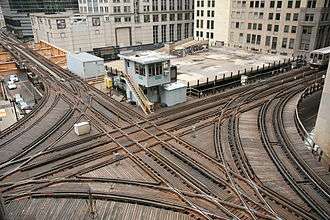
Lake Street begins (or, rather, ends, in the case of motor traffic) at Stetson Avenue in the Illinois Center area of the Chicago Loop (middle and lower levels extend one block further east to Columbus Drive on a multi-level structure, with a pedestrian mall on the upper level) and then runs to the west as a one-way eastbound street. From the first two-way traffic segment at Canal Street, it continues to the west through the city of Chicago before heading into the western suburbs. For most of the first 7 miles (11 km) between Wabash Avenue and Laramie Avenue, Lake Street runs beneath the elevated Green Line CTA tracks and the Union Pacific (former Chicago and Northwestern) railroad tracks near Central Avenue.
In Stone Park, Lake Street runs concurrent with U.S. 20 at Mannheim Road. Eastbound U.S. 20 turns south with U.S. Routes 12 and 45. Westbound U.S. 20 follows Lake Street westbound to the western terminus of Lake Street for 20.7 miles (33.3 km).[1] A portion of Lake Street in Elmhurst has been replaced by the Eisenhower Expressway; at this point, U.S. 20 runs on the Eisenhower for 0.97 mi (1.56 km).[2] Lake Street parallels the Eisenhower until the interchange with Interstate 355.
Continuing west, Lake Street becomes a six lane divided highway while passing through the western suburbs; at Roselle, it becomes a four-lane divided highway. At the current western terminus of the Elgin-O'Hare Expressway41.9819°N 88.13957°W, Lake Street becomes six lanes once again through Hanover Park. Just west of the Villa Olivia Country Club, Lake Street ends at the eastern terminus of the Elgin Bypass.
History
Most of Lake Street was once marked as U.S. 20.[3] In 1938, U.S. 20 was moved onto Mannheim Road and La Grange Road. The remaining segment of Lake Street became City U.S. 20.[4] In 1960, it was renamed to Business U.S. 20.[5] In 1968, all designations were dropped from Lake Street east of Mannheim Road.[6][7]
Major intersections
| County | Location | mi[8][9] | km | Destinations | Notes | ||
|---|---|---|---|---|---|---|---|
| Cook | Chicago | 0.0 | 0.0 | North Upper Stetson Avenue | Eastern terminus | ||
| 1.1 | 1.8 | Westbound I-90/I-94 exit; eastbound I-90/I-94 entrance | |||||
| 6.3 | 10.1 | ||||||
| Oak Park–River Forest line | 9.4 | 15.1 | |||||
| Maywood | 10.9 | 17.5 | |||||
| Stone Park | 13.5 | 21.7 | Eastern end of US 20 concurrency | ||||
| Northlake | 15.4 | 24.8 | Northbound I-294 entrance only | ||||
| DuPage | Elmhurst | 15.6 | 25.1 | Eastbound US 20 (Lake Street) entrance only | |||
| 15.7 | 25.3 | Eastbound US 20 (Lake Street) entrance only; western end of US 20 concurrency (eastern segment) | |||||
| Gap in route | |||||||
| 17.4 | 28.0 | Interchange; eastern end of US 20 concurrency (western segment) | |||||
| Elmhurst–Addison line | 18.5 | 29.8 | Interchange | ||||
| Medinah | 22.5 | 36.2 | |||||
| Addison | 22.7 | 36.5 | Interchange | ||||
| Hanover Park | 28.6 | 46.0 | I-PASS only interchange; current IL 390 terminus | ||||
| Cook | Bartlett | 32.7 | 52.6 | Interchange | |||
| Elgin | 34.4 | 55.4 | Shales Parkway | Western terminus | |||
| Continuation beyond Shales Parkway | |||||||
| 1.000 mi = 1.609 km; 1.000 km = 0.621 mi | |||||||
References
- Google Maps estimate.
- Illinois Technology Transfer Center (2006). "T2 GIS Data". Archived from the original on August 10, 2007. Retrieved November 8, 2007.
- Illinois Secretary of State; Rand McNally (1936). Road Map Illinois (Map). [c. 1:950,000 and c. 1:1,110,000]. Springfield: Illinois Secretary of State – via Illinois Digital Archives.
- Illinois Secretary of State; Rand McNally (1939). Illinois Road Map (Map) (1939–1940 ed.). c. 1:918,720. Springfield: Illinois Secretary of State – via Illinois Digital Archives.
- Illinois Division of Highways; H.M. Gousha (1960). Illinois Official Highway Map (Map). [1:790,00]. Springfield: Illinois Division of Highways – via Illinois Digital Archives.
- Carlson, Rich (May 29, 2007). "Routes 1 thru 20:". Retrieved September 19, 2007.
- Illinois Division of Highways (1968). Illinois Official Highway Map (Map). [1:772,500]. Springfield: Illinois Division of Highways – via Illinois Digital Archives.
- "Lake Street (Chicago-Elmhurst)".
- "Lake Street (Elmhurst-Elgin)".
| By topic | |
|---|---|
| |