Lake Ogawara
Lake Ogawara (小川原湖, Ogawarako) is Japan's eleventh largest lake (by area) and the largest in Aomori Prefecture.[1] It spans the boundaries of the city of Misawa, the town of Tōhoku, and the village of Rokkasho in Kamikita District.
| Lake Ogawara | |
|---|---|
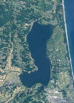 Landsat image of Lake Ogawara 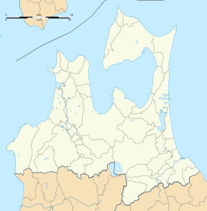  | |
| Location | Aomori Prefecture |
| Coordinates | 40°47′00″N 141°19′00″E |
| Type | dimictic lake |
| Primary outflows | Pacific Ocean |
| Basin countries | Japan |
| Surface area | 63.2 km2 (24.4 sq mi) |
| Average depth | 11 m (36 ft) |
| Max. depth | 25 m (82 ft) |
| Water volume | 0.714 km3 (579,000 acre⋅ft) |
| Residence time | 0.8 years |
| Shore length1 | 67.4 km (41.9 mi) |
| Surface elevation | 0 m (0 ft) |
| Frozen | December to March |
| 1 Shore length is not a well-defined measure. | |
Data
The lake has an area of 63.2 km² and holds 0.714 km³ of water. Its circumference is 67.4 kilometers. At its deepest point, the water is 25 meters deep, with an average depth of 11 meters. The surface is at sea level. The lake is shallow (less than 2 meters deep) from the shoreline to a distance of approximately 200 meters, whereupon the depth drops off precipitously. The edge of Lake Ogawara is very near the coast of the Pacific Ocean, and the sand bar guarding its mouth has been breached numerous times by storms and typhoons, thus accounting for the brackish water of the lake. There are four inflowing rivers, all coming from the Hakkōda Mountain Range. The only outflow is the Takase River, which drains the lake to the Pacific Ocean.
History
Lake Ogawara was originally a marine bay, which became a lake approximately 3,000 years ago by the formation of a sand bar at its mouth. The shoreline around Lake Ogawara has been settled since prehistoric times, and numerous Jōmon period remains and shell middens have been discovered.
The lake was used by the Imperial Japanese Navy Air Service units at Misawa Airfield to practice for the attack on Pearl Harbor during World War II due to its similarity in depth to Pearl Harbor in Hawaii.
The Japanese government initiated a project beginning in the 1970s to convert the lake from brackish to fresh water to serve as a source of drinking, industrial and irrigation water despite the adverse environmental impact.
On February 20, 2018, an F-16 of the US Air Force based at the nearby Misawa Air Base dumped two external fuel tanks into the lake after experiencing an engine fire.[2][3][4]
Environment
Lake Ogawara is an abundant habitat for fish and birds, and is recognized as such by the Japanese Ministry of the Environment. A variety of marimo occurs naturally in the lake.
In 1996 the sound of wild birds on the shores of Lake Ogawara was selected by the Ministry of the Environment as one of the 100 Soundscapes of Japan.[5]
In 2002, the Ministry of the Environment classified Lake Ogawara to be one of the 500 Important Wetlands in Japan, particularly for its biodiversity of aquatic flora, insects, and freshwater shellfish. The lake also serves as a habitat for migratory wildfowl.[6]
The lake was previously home to the critically endangered Hucho perryi, which was last spotted in 1943. Migratory birds include the whooper swan and tundra swan, among others.
Economic activity
The lake is a commercial source of cultivated Japanese smelt, icefish, goby and shijimi.
Sources
This article incorporates material from the article 小川原湖 (Ogawarako) in the Japanese Wikipedia, retrieved on November 11, 2009.
References
- Geospatial Information Authority of Japan (2015-03-06). "Archived copy" 平成26年全国都道府県市区町村別面積調 湖沼面積(20傑) (PDF) (in Japanese). Archived from the original (PDF) on 2015-04-02. Retrieved 2015-03-08.CS1 maint: archived copy as title (link)
- "U.S. fighter jet dumps fuel tanks into Aomori Prefecture lake after engine fire". Japan Times. February 20, 2018. Retrieved February 21, 2018.
- "UPDATE: U.S. fighter dumps fuel tanks during flight after engine fire". Asahi Shimbun. February 20, 2018. Retrieved February 21, 2018.
- Yamaguchi, Mari (February 20, 2018). "US F-16 dumps fuel tanks near fishermen in Japan lake". Air Force Times. Retrieved February 21, 2018.
- "北海道・東北 - チャグチャグ馬コの鈴の音". Ministry of the Environment. Archived from the original on 8 June 2012. Retrieved 18 April 2011.
- "500 Important Wetlands in Japan". No. 64 Ogawara-ko Wetlands (including Obuchi-numa, Takahoko-numa, Ichiyanagi-numa, Tamogi-numa, Takase-gawa and Ogawara-ko). The Ministry of the Environment, Japan. 2002. Archived from the original on 6 January 2013. Retrieved 4 March 2017.
External links
| Wikimedia Commons has media related to Lake Ogawara. |