La Chapelle-Gonaguet
La Chapelle-Gonaguet is a commune in the Dordogne department in Nouvelle-Aquitaine in southwestern France.
La Chapelle-Gonaguet | |
|---|---|
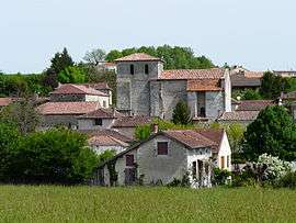 The church and surroundings in La Chapelle-Gonaguet | |
Location of La Chapelle-Gonaguet 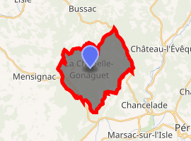
| |
 La Chapelle-Gonaguet  La Chapelle-Gonaguet | |
| Coordinates: 45°13′53″N 0°36′50″E | |
| Country | France |
| Region | Nouvelle-Aquitaine |
| Department | Dordogne |
| Arrondissement | Périgueux |
| Canton | Saint-Astier |
| Intercommunality | agglomération Périgourdine |
| Government | |
| • Mayor (2008–2014) | Alain Le Pape |
| Area 1 | 19.07 km2 (7.36 sq mi) |
| Population (2017-01-01)[1] | 1,069 |
| • Density | 56/km2 (150/sq mi) |
| Time zone | UTC+01:00 (CET) |
| • Summer (DST) | UTC+02:00 (CEST) |
| INSEE/Postal code | 24108 /24350 |
| Elevation | 95–233 m (312–764 ft) (avg. 179 m or 587 ft) |
| 1 French Land Register data, which excludes lakes, ponds, glaciers > 1 km2 (0.386 sq mi or 247 acres) and river estuaries. | |
Population
| Year | Pop. | ±% |
|---|---|---|
| 1800 | 506 | — |
| 1806 | 471 | −6.9% |
| 1821 | 651 | +38.2% |
| 1831 | 689 | +5.8% |
| 1836 | 677 | −1.7% |
| 1841 | 651 | −3.8% |
| 1846 | 637 | −2.2% |
| 1851 | 647 | +1.6% |
| 1856 | 623 | −3.7% |
| 1861 | 580 | −6.9% |
| 1866 | 558 | −3.8% |
| 1872 | 577 | +3.4% |
| 1876 | 598 | +3.6% |
| 1881 | 575 | −3.8% |
| 1886 | 559 | −2.8% |
| 1891 | 553 | −1.1% |
| 1896 | 523 | −5.4% |
| 1901 | 506 | −3.3% |
| 1906 | 524 | +3.6% |
| 1911 | 483 | −7.8% |
| 1921 | 449 | −7.0% |
| 1926 | 428 | −4.7% |
| 1931 | 408 | −4.7% |
| 1936 | 399 | −2.2% |
| 1946 | 367 | −8.0% |
| 1954 | 372 | +1.4% |
| 1962 | 348 | −6.5% |
| 1968 | 307 | −11.8% |
| 1975 | 331 | +7.8% |
| 1982 | 421 | +27.2% |
| 1990 | 703 | +67.0% |
| 1999 | 863 | +22.8% |
| 2008 | 1,042 | +20.7% |
See also
References
- "Populations légales 2017". INSEE. Retrieved 6 January 2020.
| Wikimedia Commons has media related to La Chapelle-Gonaguet. |
| Authority control |
|
|---|
This article is issued from Wikipedia. The text is licensed under Creative Commons - Attribution - Sharealike. Additional terms may apply for the media files.