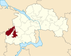
Kryvyi Rih Raion
Kryvyi Rih Raion (Ukrainian: Криворізький район) is a raion (district) of Dnipropetrovsk Oblast, southeastern-central Ukraine. Its administrative centre is located at the city of Kryvyi Rih, which is incorporated separately as a city of oblast significance and is not a part of the raion. Population: 44,340 (2019 est.)[1].
Kryvyi Rih Raion Криворізький район | |
|---|---|
Raion | |
 | |
 Flag  Coat of arms | |
 | |
| Coordinates: 47°59′4.9″N 33°5′29″E | |
| Country | |
| Region | Dnipropetrovsk Oblast |
| Admin. center | Kryvyi Rih |
| Subdivisions | List
|
| Area | |
| • Total | 1,347 km2 (520 sq mi) |
| Population (2019) | |
| • Total | 44,340 |
| • Density | 33/km2 (85/sq mi) |
| Time zone | UTC+02:00 (EET) |
| • Summer (DST) | UTC+03:00 (EEST) |
| Area code | +380 |
Geography
- Kryvyi Rih (Криворізький район)
- Urban-type settlements under the district's jurisdiction:
- Khrystoforivka (Христофорівка)
- Radushne (Радушне)
- Urban-type settlements under the district's jurisdiction:
- Kryvyi Rih (Криворізький район)
Climate
Kryvyi Rih experiences a dry continental climate (Dfb bordering on Dfa) according to the Köppen climate classification system, like much of Ukraine. This tends to generate warm summers and cold winters with relatively low precipitation. Snowfalls are not common in the city, due to the urban warming effect. However,[2] districts that surround the city receive more snow and roads leading out of the city can be closed[3] due to snow.
| Climate data for Kryvyi Rih | |||||||||||||
|---|---|---|---|---|---|---|---|---|---|---|---|---|---|
| Month | Jan | Feb | Mar | Apr | May | Jun | Jul | Aug | Sep | Oct | Nov | Dec | Year |
| Record high °C (°F) | 13.0 (55.4) |
18.9 (66.0) |
23.5 (74.3) |
28.9 (84.0) |
35.8 (96.4) |
36.4 (97.5) |
38.6 (101.5) |
39.6 (103.3) |
32.2 (90.0) |
31.7 (89.1) |
21.7 (71.1) |
15.3 (59.5) |
39.6 (103.3) |
| Average high °C (°F) | −0.2 (31.6) |
0.6 (33.1) |
7.3 (45.1) |
15.6 (60.1) |
22.0 (71.6) |
25.2 (77.4) |
28.7 (83.7) |
28.9 (84.0) |
21.8 (71.2) |
13.9 (57.0) |
7.8 (46.0) |
0.7 (33.3) |
14.4 (57.9) |
| Daily mean °C (°F) | −3.5 (25.7) |
−3.1 (26.4) |
1.9 (35.4) |
9.6 (49.3) |
15.9 (60.6) |
19.5 (67.1) |
21.8 (71.2) |
21.2 (70.2) |
15.6 (60.1) |
9.1 (48.4) |
2.3 (36.1) |
−2.1 (28.2) |
9.0 (48.2) |
| Average low °C (°F) | −5.5 (22.1) |
−5.4 (22.3) |
−0.9 (30.4) |
4.3 (39.7) |
10.5 (50.9) |
14.1 (57.4) |
16.9 (62.4) |
16.3 (61.3) |
11.1 (52.0) |
5.2 (41.4) |
1.5 (34.7) |
−4.4 (24.1) |
4.3 (39.7) |
| Record low °C (°F) | −27.2 (−17.0) |
−27.3 (−17.1) |
−21.0 (−5.8) |
−8.9 (16.0) |
−1.6 (29.1) |
2.8 (37.0) |
7.3 (45.1) |
5.0 (41.0) |
−3.7 (25.3) |
−10.0 (14.0) |
−18.6 (−1.5) |
−24.5 (−12.1) |
−27.3 (−17.1) |
| Average precipitation mm (inches) | 30 (1.2) |
29 (1.1) |
24 (0.9) |
28 (1.1) |
45 (1.8) |
62 (2.4) |
58 (2.3) |
32 (1.3) |
38 (1.5) |
37 (1.5) |
31 (1.2) |
28 (1.1) |
442 (17.4) |
| Source: Pogoda.ru.net[4] | |||||||||||||
References
- "Чисельність наявного населення України (Actual population of Ukraine)" (PDF) (in Ukrainian). State Statistics Service of Ukraine. Retrieved 23 May 2020.
- http://www.0564.ua/news/110563
- "Archived copy". Archived from the original on 2017-12-29. Retrieved 2015-04-26.CS1 maint: archived copy as title (link)
- "Pogoda.ru.net" (in Russian). May 2011. Retrieved 3 July 2012.
Places adjacent to Kryvyi Rih Raion | |
|---|---|
| Raions | |||||
|---|---|---|---|---|---|
| Hromadas | |||||
| Cities |
| ||||
| |||||