Krasnoperekopsk Raion
Krasnoperekopsk Raion (Ukrainian: Красноперекопський район, Russian: Красноперекопский район, Crimean Tatar: Krasnoperekopsk rayonı) is one of the 25 regions of the Autonomous Republic of Crimea, a territory recognized by a majority of countries as part of Ukraine and incorporated by Russia as the Republic of Crimea. It is situated in the northern part of the republic. The administrative center of the raion is the town of Krasnoperekopsk, though it is not a part of the district and is incorporated separately. Population: 24,738 (2014 Census).[1]
Krasnoperekopsk Raion Krasnoperekopsk rayonı | |
|---|---|
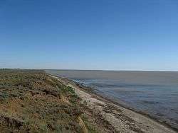 Karkinit Bay, Krasnoperekopsky District | |
 Flag .png) Seal | |
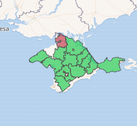
Raion location within Crimea | |
| Country | Disputed: |
| Republic | Crimea |
| Capital | Krasnoperekopsk |
| Subdivisions | List
|
| Area | |
| • Total | 1,231 km2 (475 sq mi) |
| Population (2014) | |
| • Total | 24,738 |
| • Density | 20/km2 (52/sq mi) |
| Time zone | UTC+3 (MSK) |
| Dialing code | +380-6565 |
| Website | krpero |
References
- Russian Federal State Statistics Service (2014). "Таблица 1.3. Численность населения Крымского федерального округа, городских округов, муниципальных районов, городских и сельских поселений" [Table 1.3. Population of Crimean Federal District, Its Urban Okrugs, Municipal Districts, Urban and Rural Settlements]. Федеральное статистическое наблюдение «Перепись населения в Крымском федеральном округе». ("Population Census in Crimean Federal District" Federal Statistical Examination) (in Russian). Federal State Statistics Service. Retrieved January 4, 2016.
| Raions | |||||
|---|---|---|---|---|---|
| Municipalities |
| ||||
| Cities |
| ||||
| |||||
This article is issued from Wikipedia. The text is licensed under Creative Commons - Attribution - Sharealike. Additional terms may apply for the media files.