Belogorsk (Crimea)
Belogorsk (until 1944 — Qarasuvbazar, Ukrainian: Білогірськ, romanized: Bilohirsk; Russian: Белого́рск, romanized: Belogorsk) is a town and the administrative centre in Belohirsk Raion, one of the raions (districts) of the Autonomous Republic of Crimea, a territory recognised by a majority of countries as part of Ukraine and annexed by Russia. Population: 16,354 (2014 Census).[2]
Belogorsk, Bilohirsk, Qarasuvbazar Qarasuvbazar | |
|---|---|
 Coat of arms | |
.svg.png) Belogorsk, Bilohirsk, Qarasuvbazar Location of Belogorsk within Crimea | |
| Coordinates: 45°3′16″N 34°36′8″E | |
| Country | Disputed between Russia and Ukraine[1] |
| Raion | Bilohirsk Raion |
| Location in Russia | |
| Location in Ukraine | |
| Area | |
| • Total | 5.42 km2 (2.09 sq mi) |
| Elevation | 180 m (590 ft) |
| Population (2014) | |
| • Total | 16,354 |
| • Density | 3,398.52/km2 (8,802.1/sq mi) |
| Time zone | UTC+3 (MSK) |
| Postal code | 97600 — 97609 |
| Area code(s) | +7-36559 |
| Website | http://belogorsk.crimea.ua/ |
%2C_%D0%9A%D1%80%D1%8B%D0%BC.jpg)
The city is located 25 miles east-northeast of Simferopol on the Biyuk Karasu river. The city's both Russian and Ukrainian names literally are translated as "white mountains," and the Crimean Tatar name Qarasuvbazar means "bazaar on the Karasu river."
History
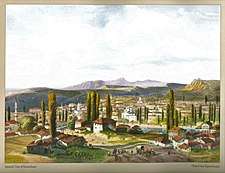
The site is low, but the town is surrounded by hills, which afford protection from the north wind. The town has a characteristic Crimean Tatar atmosphere. Placed on the high road between Simferopol and Kerch, and in the midst of a country rich in cereal land, vineyards and gardens, Qarasubazar used to be a chief seat of commercial activity in Crimea; including a huge slave market and a large black water market,[3] but it is gradually declining in importance, though still a considerable centre for the export of fruit.
The caves of Akkaya close by give evidence of early occupation of the area. When in 1736 Khan Fetih Giray was driven by the Russian Empire from Bakhchisaray, he settled at Karasubazar, but next year the town was captured, plundered and burned by the Russian army.
Retreating NKVD shot a number of local people in the streets in 1941.[4] Qarasuvbazar was occupied by the German army from 1941 – 1944 during World War II. During the occupation, the Germans executed the town's Jews in an anti-tank trench.[5]
After the deportation of the Crimean Tatars, the town was renamed Belogorsk per Stalinist detatarization policy.
References
- This place is located on the Crimean peninsula, most of which is the subject of a territorial dispute between Russia and Ukraine. According to the political division of Russia, there are federal subjects of the Russian Federation (the Republic of Crimea and the federal city of Sevastopol) located on the peninsula. According to the administrative-territorial division of Ukraine, there are the Ukrainian divisions (the Autonomous Republic of Crimea and the city with special status of Sevastopol) located on the peninsula.
- Russian Federal State Statistics Service (2014). "Таблица 1.3. Численность населения Крымского федерального округа, городских округов, муниципальных районов, городских и сельских поселений" [Table 1.3. Population of Crimean Federal District, Its Urban Okrugs, Municipal Districts, Urban and Rural Settlements]. Федеральное статистическое наблюдение «Перепись населения в Крымском федеральном округе». ("Population Census in Crimean Federal District" Federal Statistical Examination) (in Russian). Federal State Statistics Service. Retrieved January 4, 2016.
- Josiah Conder Belogorsk (Crimea), p. 266, at Google Books
- http://www.iccrimea.org/historical/crimeanturks.html
- "Yahad-In Unum Interactive Map". Execution Sites of Jewish Victims Investigated by Yahad-In Unum. Retrieved 20 January 2015.

External links
- jewishgen.org
- The murder of the Jews of Qarasuvbazar during World War II, at Yad Vashem website.
| Raions | |||||
|---|---|---|---|---|---|
| Municipalities |
| ||||
| Cities |
| ||||
| |||||