Kilmacnevan (civil parish)
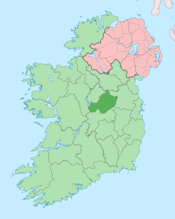
Kilmacnevan (Irish: Cill Mhic Naomháin)[1] is a civil parish in County Westmeath, Ireland. It is located about 15.81 kilometres (10 mi) west–north–west of Mullingar.
Kilmacnevan Cill Mhic Naomháin | |
|---|---|
 Kilmacnevan Location of Kilmacnevan within County Westmeath in the Republic of Ireland | |
| Coordinates: 53°35′8″N 7°33′39″W | |
| Country | |
| Province | Leinster |
| County | County Westmeath |
| Irish grid reference | N291595 |
Kilmacnevan is one of 6 civil parishes in the barony of Moygoish in the Province of Leinster. The civil parish covers 5,010.3 acres (20.276 km2).
Kilmacnevan civil parish comprises 11 townlands: Ballintue, Ballynacarrow, Calliaghstown, Churchtown, Conlanstown, Deerpark, Emper, Kilmacnevan, Lakingstown, Laragh and Rathmore.
The neighbouring civil parishes are: Rathaspick to the north, Kilbixy to the east, Piercetown (barony of Rathconrath) and Rathconrath (barony of Rathconrath) to the south and Agharra (barony of Shrule, County Longford) and Rathreagh (barony of Ardagh, County Longford) to the west.[2][3]
References
- Kilmacnevan civil parish Logainm.ie Retrieved on 27 June 2015.
- Kilmacnevan civil parish, Co. Westmeath Townlands.ie Retrieved on 27 June 2015.
- Kilmacnevan civil parish, Co. Westmeath The IreAtlas Townland Data Base Retrieved on 27 June 2015.
External links
- Kilmacnevan civil parish at the IreAtlas Townland Data Base
- Kilmacnevan civil parish at Townlands.ie
- Kilmacnevan civil parish at Logainm.ie