Kenmore, Perth and Kinross
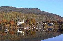
Kenmore (Gaelic: A' Cheannmhor)[1][2] is a small village in Perthshire, in the Highlands of Scotland, located where Loch Tay drains into the River Tay.[3]
Kenmore
| |
|---|---|
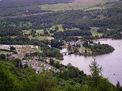 Kenmore viewed from Black Rock | |
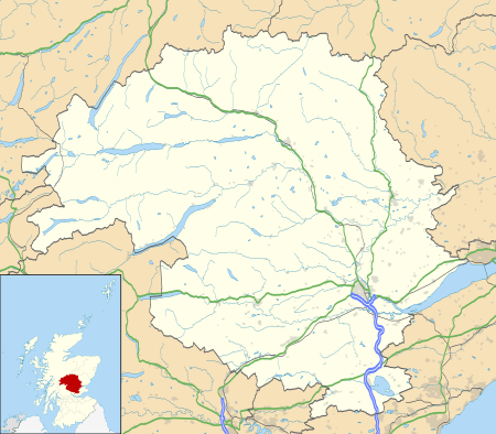 Kenmore Location within Perth and Kinross | |
| OS grid reference | NN773454 |
| Council area | |
| Country | Scotland |
| Sovereign state | United Kingdom |
| Post town | Aberfeldy |
| Postcode district | PH15 |
| Police | Scotland |
| Fire | Scottish |
| Ambulance | Scottish |
| UK Parliament | |
| Scottish Parliament | |
History
The village dates from the 16th century. It and the neighbouring Castle were originally known as Balloch (from Gaelic bealach, 'pass'). The original village was sited on the north side of river approximately two miles (three kilometres) from its present site and was known as Inchadney. In 1540 Sir Colin Campbell of Glenorchy started the construction of Balloch castle on the opposite bank of the river and the entire village was moved to a prominent headland by the shores of Loch Tay, hence the name Kenmore, which translates from Scots Gaelic to "big (or large) head". The village as it is seen today is a model village laid out by 3rd Earl of Breadalbane in 1760.
Landmarks and tourism
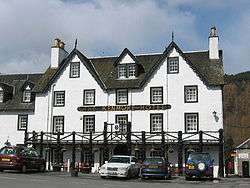
The Kenmore Hotel, commissioned in 1572 by the then laird Colin Campbell, has its origins in a tavern built around 70 years earlier offering accommodation and refreshments. It is reputed to be Scotland's oldest hotel.
Taymouth Castle, another Campbell creation, was built by John Campbell, 2nd Marquess of Breadalbane (d. 1862) on the site of its late medieval predecessor, Balloch Castle (built 1550 by the Campbells of Glenorchy, ancestors of the Marquesses of Breadalbane, demolished 1805). This enormous mansion, in neo-Gothic style, was completed in time for the visit of Queen Victoria in 1842. No expense was spared on the interior, which was decorated with the utmost sumptuousness. Taymouth Castle is now privately owned and has a fine golf course in its grounds. Plans to restore the Castle to its mid-19th century glory and convert it into a luxury hotel are currently ongoing. Kenmore Bridge dates from 1774 and the village as it is today was laid out in the 18th Century by the third Earl of Breadalbane. It retains many of its original buildings and historic appearance.
Around two miles (three kilometres) northeast of the village by the side of the A827 road is a complex multi-phase stone circle known as Croft Moraig Stone Circle.[4]
To the southwest, between Kenmore and Acharn, the waterside settlement of Croft-na-Caber has been redeveloped into a number of tourist attractions. The Scottish Crannog Centre (formerly the Crannog Reconstruction Project) is an open-air museum on the south of Loch Tay Road. It features an accurate full-size reconstruction of a crannog, an Iron Age artificial island, of which more than 20 (most now submerged) have been found in Loch Tay. The crannog mockup is based on the real Oakbank Crannog archaeological site off the north shore of the loch. The visitor centre also displays artefacts from nearby excavations, which are funded in part by the proceeds from this attraction. The Croft-na-Caber Watersports & Activity Centre, originally planned as a £20 million sailing resort in 2009,[5] now offers additional activities, including hydraboarding and canyoning. The original Croft-na-Caber Hotel closed in the 2000s, though the successor resort is served by other area hotels, the largest of which is the Kenmore Hotel.
The biggest island in the loch, known as the Isle of Loch Tay, or in Gaelic Eilean nam Ban-naomh, 'Isle of Holy Women', is just north of Kenmore. It was the site of a nunnery in the 12th century and was the burial place of Queen Sibylla (d. 1122), wife of Alexander I of Scotland (1107–24). A castle was built on the island in the later Middle Ages. Much larger in area than the other crannogs, it is unclear to what extent this island is natural, or has been built up with landfill over the centuries.
Climate
As with the rest of the British Isles and Scotland, Kenmore experiences a maritime climate with cool summers and mild winters. The nearest official Metoffice weather station for which online records are available is Ardtalnaig, about 6 miles (10 kilometres) southwest of the settlement. Despite its location in the interior of Scotland, the vast Loch Tay adjacent to the village provides some insulation from extreme frost – unlike many weather observing sites in this area of Scotland, no month averages a minimum below freezing point, and no temperatures below −16.0 °C (3.2 °F) have been reported since at least 1960.
| Climate data for Ardtalnaig, 130 m (430 ft) asl, 1971-2000, extremes 1960- (Weather station 6 miles (10 km) SW of Kenmore) | |||||||||||||
|---|---|---|---|---|---|---|---|---|---|---|---|---|---|
| Month | Jan | Feb | Mar | Apr | May | Jun | Jul | Aug | Sep | Oct | Nov | Dec | Year |
| Record high °C (°F) | 14.0 (57.2) |
14.8 (58.6) |
17.8 (64.0) |
25.0 (77.0) |
26.5 (79.7) |
31.4 (88.5) |
30.1 (86.2) |
29.3 (84.7) |
26.2 (79.2) |
22.5 (72.5) |
16.1 (61.0) |
13.9 (57.0) |
31.4 (88.5) |
| Average high °C (°F) | 5.5 (41.9) |
5.6 (42.1) |
8.1 (46.6) |
11.2 (52.2) |
14.9 (58.8) |
17.4 (63.3) |
19.2 (66.6) |
18.6 (65.5) |
15.3 (59.5) |
11.7 (53.1) |
8.1 (46.6) |
6.3 (43.3) |
11.9 (53.4) |
| Average low °C (°F) | 0.6 (33.1) |
0.7 (33.3) |
1.7 (35.1) |
3.0 (37.4) |
5.4 (41.7) |
8.4 (47.1) |
10.4 (50.7) |
10.1 (50.2) |
8.0 (46.4) |
5.6 (42.1) |
2.8 (37.0) |
1.4 (34.5) |
4.9 (40.8) |
| Record low °C (°F) | −15.9 (3.4) |
−9.8 (14.4) |
−12.2 (10.0) |
−5.6 (21.9) |
−2 (28) |
0.6 (33.1) |
3.3 (37.9) |
1.7 (35.1) |
−0.3 (31.5) |
−4.0 (24.8) |
−7.9 (17.8) |
−13.4 (7.9) |
−15.9 (3.4) |
| Average precipitation mm (inches) | 186.5 (7.34) |
119.7 (4.71) |
131.9 (5.19) |
66.6 (2.62) |
71.7 (2.82) |
64.3 (2.53) |
66.7 (2.63) |
75.1 (2.96) |
115.6 (4.55) |
140.9 (5.55) |
141.3 (5.56) |
163.8 (6.45) |
1,343.9 (52.91) |
| Mean monthly sunshine hours | 21.4 | 50.9 | 88.4 | 131.7 | 173.3 | 162.9 | 161.8 | 141.7 | 103.8 | 67.9 | 33.3 | 10.9 | 1,147.8 |
| Source 1: Met Office[6] | |||||||||||||
| Source 2: Royal Dutch Meteorological Institute/KNMI[7] | |||||||||||||
References
- Iain Mac an Tàilleir. "Placenames" (PDF). Scottish Parliament. Retrieved 24 August 2012.
- "Gaelic Place-Names of Scotland database". Ainmean-Àite na h-Alba. Retrieved 24 August 2012.
- "Loch Tay and Glen Dochart", Ordnance Survey Landranger Map (B2 ed.), 2008, ISBN 0-319-22979-3
- "Croft Moraig". Canmore. Royal Commission on the Ancient and Historical Monuments of Scotland. Retrieved 15 August 2015.
- "£20m Croft-Na-Caber plans approved". www.healthclubmanagement.co.uk.
- "Ardtalnaig 1971-2000 averages". Met Office. Archived from the original on 19 October 2011. Retrieved 2 November 2011.
- "Ardtalnaig monthly extremes". KNMI. Retrieved 2 November 2011.