Kea, Cornwall
Kea (/kiː/ KEE;[1] Cornish: Sen Ke) is a civil parish and village in Cornwall, England, United Kingdom. It is a "large straggling parish" [2] in a former mining area south of Truro.
Kea
| |
|---|---|
.jpg) Old Kea church tower | |
 Kea Location within Cornwall | |
| Population | 1,482 (Civil Parish, 2011 including Baldhu , Bissoe , Calenick , Chapel , Come-to-Good , Coombe , Helston Water and Hugus) |
| OS grid reference | SW 810 427 |
| Civil parish |
|
| Unitary authority | |
| Ceremonial county | |
| Region | |
| Country | England |
| Sovereign state | United Kingdom |
| Post town | TRURO |
| Postcode district | TR3 |
| Dialling code | 01872 |
| Police | Devon and Cornwall |
| Fire | Cornwall |
| Ambulance | South Western |
| UK Parliament | |
Kea village is situated just over one mile (1.6 km) southwest of Truro.[3]
Old Kea is situated two miles (3 km) to the east on the west bank of the Truro River at grid reference SW 843 417. St Kea reputedly landed at Old Kea on his first visit to Cornwall and established a church there, which was the parish church until replaced by All Hallows.
Today, the parish is mainly agricultural, and is noted for giving its name to the damson-type Kea plum. It is bounded to the north by Calenick Creek and Truro civil parish; to the east by the Truro River and River Fal; to the south by the parishes of Feock, Perranarworthal and Gwennap; and to the west by Kenwyn.[2] Other settlements in the parish include Calenick, Come-to-Good, Killiow, Nansavallan, Playing Place, Porth Kea,[3] and the tiny hamlet of Quenchwell consisting of a few houses and a chapel. It takes its name from the Quench-well, a natural spring.[4]
Kea was described in 1870–72, John Marius Wilson's Imperial Gazetteer of England and Wales (1870) as:
- A parish and a sub-district in Truro district, Cornwall. The parish lies on the Falmouth and Redruth railways, 2¼ miles SSW of Truro; is bounded, on the E, by the river Fal, on the N, by Kenwyn, on the W, by Gwennap; and contains parts of the chapelries of Baldhu, Chacewater, and Mithian. Real property £7,158 of which £1,234 are in mines. Pop(ulation) in 1861 3,949. Houses, 824. The manor belongs to Viscount Falmouth.[5]
Churches and schools
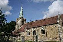
All Hallows church is in Kea village at grid reference SW 809 426. It was built in 1895 to replace a church of 1802 which was the work of James Wyatt. The church has a steep tiled roof and a lead spire. The font is Norman and of the Altarnun type.[6] This present church was consecrated 4 June 1896.[2] The church of St Kea at Old Kea was the parish church until All Hallows was built. Later, the church at Old Kea was pulled down and only the tower remains today.[2] A small chapel now stands beside the ruined medieval tower and services are held there twice a month[7]
Kea Monastery was a monastery probably at Kea of which little is known. "The mysterious land-owning monastery of St Cheus mentioned in Domesday (in Powder), 1085, possibly refers to Kea."—Charles Henderson, in Cornish Church Guide, 1925, p. 116.
There is a school in the parish, Kea Community Primary School, which caters for 200 pupils aged between 4 and 11 years. The school stands at a crossroads half-a-mile (1 km) east of Kea village at SW 818 425[8][9]
Houses
At Calenick and Killiow are 18th-century houses of two storeys. Calenick House contains remains of a much older building; it is of seven bays and there is a separate clock tower with a cupola, dated 1752. Killiow House is somewhat later and was extended c. 1850.[10] The latter was once the home of Theophila Gwatkin (née Palmer; 1757–1848) and Robert Lovell Gwatkin (1757–1843).
A Quaker Meeting House opened in Come-to-Good, Kea, in 1710.
Notable people
- Margaret Steuart Pollard, writer and Cornish bard[4]
- Bernard Edmund 'Beakus' Penrose (1903-88), associated with Carrington and other figures in and around Bloomsbury, and maker of three famous amateur short films at Ham Spray, where Lytton Strachey and Carrington lived, 'When Beakus Came to Stay', now on You Tube. He is buried in the churchyard of All Hallows.
Gallery
 Coombe, Kea, the home of Kea plums
 Kea Community Primary School buildings being extended in 2006
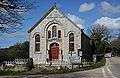 Quenchwell Bible Christian Memorial Chapel
References
- Pointon, G.E. (1983). BBC Pronouncing Dictionary of British Names. Oxford University Press. p. 130. ISBN 0192129767.
- GENUKI website; Kea; retrieved April 2010
- Ordnance Survey: Landranger map sheet 204 Truro & Falmouth ISBN 978-0-319-23149-4
- Pollard, Peggy (1947) Cornwall. London: Paul Elek; pp. 11-13
- Vision of Britain website. Retrieved May 2010
- Pevsner, N. (1970) Cornwall; 2nd ed. Penguin Books; p. 84
- Church Near You website; retrieved May 2010
- SchoolsNet website; retrieved May 2010
- "Archived copy". Archived from the original on 6 April 2010. Retrieved 15 May 2010.CS1 maint: archived copy as title (link) Kea Community Primary School website; retrieved May 2010
- Pevsner, N. (1970) Cornwall; 2nd ed., revised by Enid Radcliffe. Harmondsworth: Penguin; pp. 84–86
External links
![]()
Cornwall Portal | |
| Unitary authorities | |
| Major settlements |
|
| Rivers | |
| Topics | |
Civil parishes of Truro and Falmouth constituency | ||
|---|---|---|
Cornwall Portal | ||