Kadena, Okinawa
Kadena (嘉手納町, Kadena-chō, Okinawan: Kadina) is a town located in Nakagami District, Okinawa Prefecture, Japan.[1]
Kadena Kadina 嘉手納町 | |
|---|---|
Town | |
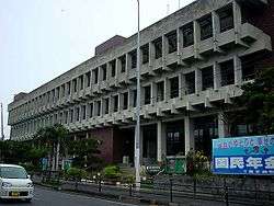 Kadena Town Hall | |
 Flag  Seal | |
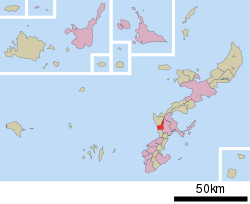 Location of Kadena in Okinawa Prefecture | |
 Kadena Kadina | |
| Coordinates: 26°21′42″N 127°45′19″E | |
| Country | Japan |
| Region | Kyushu |
| Prefecture | Okinawa Prefecture |
| District | Nakagami |
| Government | |
| • Mayor | Hiroshi Toyama |
| Area | |
| • Total | 15.04 km2 (5.81 sq mi) |
| Dimensions | |
| • Length | 8 km (5 mi) |
| • Width | 5 km (3 mi) |
| Population (October 2016) | |
| • Total | 13,671 |
| • Density | 910/km2 (2,400/sq mi) |
| Time zone | UTC+9 (Japan Standard Time) |
| Tree | Kuroki Ebenales |
| Flower | Hibiscus |
| Address | 588 Kadena, Kadena-chō, Nakagami-gun, Okinawa 904-0293 |
| Website | www |
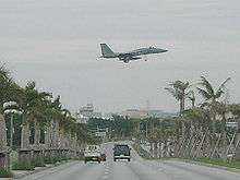
As of October 2016, the town had an estimated population of 13,671 and a density of 910 persons per km². The total area is 15.04 square kilometres (5.81 sq mi). Approximately 85% of the town is controlled by the US Government including Kadena Air Base, the second-largest base in the United States Air Force.[2][3]
Geography
Kadena faces the East China Sea to the west.[1]
History
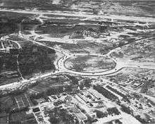
The Kadena area has some of the oldest settlement remains, in the form of shell mounds, on Okinawa Island.[4] The Hija River, the modern border between Yomitan and Kadena, was the focus of these early settlements.[4] A number of ruins of minor gusuku (castles and forts) can be found in the area.[4] Amawari, an infamous warlord, was born in the Kadena area while it was still part of Chatan.[4] Japan annexed the island in 1879, and Chatan became a village in 1908. During the Pacific War, Japan built an airstrip in the Kadena area. During the Battle of Okinawa in 1945, the United States landed on the banks of the Hija River and captured the airstrip. The airstrip became Kadena Air Force Base. On December 4th, 1948, the American military government separated Kadena from Chatan and established Kadena village.[4] The United States built Kadena Circle outside the base. On January 1st, 1976, four years after Okinawa reverted to Japanese control, Kadena was elevated to town status.[4]
Economy
The economy of Kadena is largely dependent on the presence of Kadena Air Force Base. The town otherwise produces a small amount of pineapples and sugarcane.[3]
References
- "嘉手納町" [Kadena]. Nihon Rekishi Chimei Taikei (in Japanese). Tokyo: Shogakukan. 2013. OCLC 173191044. Archived from the original on 2007-08-25. Retrieved 2013-08-19.
- 統計情報 [Statistical Information] (in Japanese). Kadena, Okinawa Prefecture, Japan: Town of Kadena. 2013. Retrieved 2013-08-19.
- "Kadena". Encyclopedia of Japan. Tokyo: Shogakukan. 2013. OCLC 56431036. Archived from the original on 2007-08-25. Retrieved 2013-08-19.
- Kadena Town. "Kadena Town's History". Kadena Town official website. http://www.town.kadena.okinawa.jp/english/history.html (accessed 2 January 2017).
External links
| Wikimedia Commons has media related to Kadena, Okinawa. |
- Kadena official website (in Japanese)
Naha (capital) | ||
| Core city | ||
| Cities |
| |
| Districts | ||
List of mergers in Okinawa Prefecture
| ||