Jurupa Valley, California
Jurupa Valley is a city in Riverside County, California. On March 8, 2011, voters approved a ballot measure, designated as Measure A, to incorporate the area into its own city; as a result, the area has been an incorporated city since July 1, 2011.[4]
Jurupa Valley, California | |
|---|---|
City | |
| City of Jurupa Valley | |
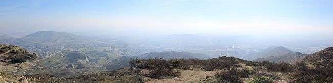
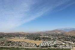 Jurupa Valley as seen from Mt. Rubidoux, 2013 | |
 Seal | |
| Nickname(s): "Jurupa" | |
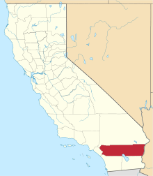
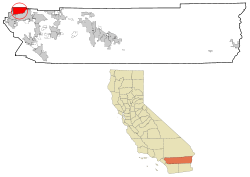 Location of Jurupa Valley in Riverside County, California. | |
 Jurupa Valley Location in the United States  Jurupa Valley Jurupa Valley (California)  Jurupa Valley Jurupa Valley (the United States) | |
| Coordinates: 34°00′N 117°29′W | |
| Country | |
| State | |
| County | |
| Incorporated (city) | July 1, 2011[1] |
| Government | |
| • Type | Council-Manager |
| • Mayor | Anthony Kelly |
| • City Council | Council members
|
| Area | |
| • City | 43.68 sq mi (113.13 km2) |
| • Land | 42.94 sq mi (111.22 km2) |
| • Water | 0.74 sq mi (1.91 km2) |
| Population (2010) | |
| • City | 94,234 |
| • Estimate (2019)[3] | 109,527 |
| • Rank | 62nd in California 277th in the United States |
| • Density | 2,550.64/sq mi (984.81/km2) |
| • Metro | 4,527,837 |
| Time zone | UTC−8 (PST) |
| • Summer (DST) | UTC−7 (PDT) |
| ZIP codes | 92509, 91752 |
| Area code(s) | 951 |
| FIPS code | 06-37692 |
| GNIS feature ID | 2702867 |
| Website | jurupavalley |
The city of Jurupa Valley covers approximately 43.5 square miles (113 km2), and had an estimated population of 109,527 as of July 1, 2019. Residents of the area had previously voted on incorporation in 1992; however, voters rejected it as well as a competing ballot measure that would have incorporated Mira Loma.[4]
History
The Jurupa Valley communities are home to notable historical events such as the Wineville Chicken Coop Murders[5] and the Stringfellow Acid Pits.
Notable historical locations also include Jensen Alvarado Ranch.
Geography
Jurupa Valley is located north and west of the Santa Ana River, south of the Riverside-San Bernardino County line, and east of Interstate 15. It includes the neighborhoods of Mira Loma, Glen Avon, Sky Country, Indian Hills, Pedley, Rubidoux, Belltown, Jurupa, Jurupa Hills, and Sunnyslope.
Demographics
Jurupa Valley was incorporated after the 2010 United States Census, but it is possible to determine an estimated population by summing up the results from the census-designated places of Glen Avon, Mira Loma, Pedley, Rubidoux and Sunnyslope.
According to the United States Census Bureau, as of July 1, 2017, the estimated population was 106,028.[6]
Government
Federal:
- In the House of Representatives, the vast majority of Jurupa Valley is part of the 41st Congressional District, represented by Democrat Mark Takano.
- A small portion of the city is located in 42nd Congressional District, represented by Republican Ken Calvert.
- California is represented in the United States Senate by Democrats Dianne Feinstein and Kamala Harris.
State: In the California State Legislature, Jurupa Valley is located in the 31st Senate District, represented by Democrat Richard Roth, and in the 60th Assembly District, represented by Democrat Sabrina Cervantes.
Local:
- In the Riverside County Board of Supervisors, Jurupa Valley is in the Second District, represented by Karen Spiegel.
Education
Jurupa Valley is home to the Jurupa Unified School District. The district operates 16 elementary schools, four middle schools, three continuation schools, and four high schools, including:[7]
- Jurupa Valley High School
- Rubidoux High School
- Patriot High School
- Rivercrest Preparatory
| Historical population | |||
|---|---|---|---|
| Census | Pop. | %± | |
| 2010 | 94,234 | — | |
| Est. 2019 | 109,527 | [3] | 16.2% |
| U.S. Decennial Census[8] | |||
Transportation
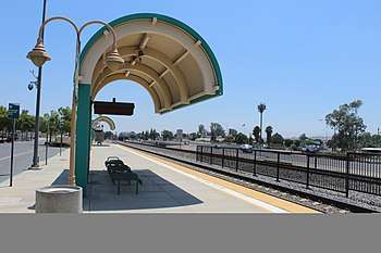
Public transportation in Jurupa Valley is provided by Riverside Transit Agency.[9] Also, Jurupa Valley/Pedley station (formerly Pedley Station) is served by Metrolink. Jurupa Valley is home to Flabob Airport, a small public-use airport. However, commercial flights are served by the nearby Ontario International Airport.
The major freeways in Jurupa Valley are Interstate 15, which serves as the city's western border, and California State Route 60, which runs along the northern side of the city.
| Climate data for Jurupa Valley, California | |||||||||||||
|---|---|---|---|---|---|---|---|---|---|---|---|---|---|
| Month | Jan | Feb | Mar | Apr | May | Jun | Jul | Aug | Sep | Oct | Nov | Dec | Year |
| Record high °F (°C) | 91 (33) |
92 (33) |
100 (38) |
101 (38) |
107 (42) |
110 (43) |
110 (43) |
112 (44) |
115 (46) |
108 (42) |
99 (37) |
92 (33) |
115 (46) |
| Average high °F (°C) | 67 (19) |
68 (20) |
71 (22) |
77 (25) |
80 (27) |
88 (31) |
93 (34) |
95 (35) |
91 (33) |
83 (28) |
74 (23) |
69 (21) |
80 (27) |
| Average low °F (°C) | 42 (6) |
44 (7) |
46 (8) |
48 (9) |
53 (12) |
58 (14) |
64 (18) |
66 (19) |
62 (17) |
53 (12) |
45 (7) |
42 (6) |
52 (11) |
| Record low °F (°C) | 24 (−4) |
27 (−3) |
28 (−2) |
31 (−1) |
32 (0) |
44 (7) |
49 (9) |
48 (9) |
42 (6) |
31 (−1) |
26 (−3) |
23 (−5) |
22 (−6) |
| Average precipitation inches (mm) | 3.45 (88) |
3.62 (92) |
2.91 (74) |
.88 (22) |
.26 (6.6) |
.03 (0.76) |
.05 (1.3) |
.15 (3.8) |
.27 (6.9) |
.56 (14) |
1.34 (34) |
2.72 (69) |
16.24 (412) |
| Average precipitation days | 6.6 | 7.2 | 5.3 | 3.5 | 1.4 | 0.3 | 0.8 | 1.0 | 1.3 | 2.5 | 4.4 | 6.4 | 40.7 |
References
- "News : Press Enterprise". pe.com.
- "2019 U.S. Gazetteer Files". United States Census Bureau. Retrieved July 1, 2020.
- "Population and Housing Unit Estimates". United States Census Bureau. May 24, 2020. Retrieved May 27, 2020.
- Stokley, Sandra (8 March 2011). "Jurupa cityhood approved". The Press-Enterprise. Retrieved 9 March 2011.
- "Mira Loma California History - Key to the City". www.usacitiesonline.com. Retrieved 2020-06-28.
- "QuickFacts: Jurupa Valley city, California". census.gov. Retrieved March 16, 2019.
- "Archived copy". Archived from the original on 2011-10-02. Retrieved 2011-03-24.CS1 maint: archived copy as title (link)
- "Census of Population and Housing". census.gov. Retrieved June 24, 2017.
- "City of Jurupa Valley > Residents > Transportation". jurupavalley.org. Retrieved 24 September 2018.
External links
| Wikivoyage has a travel guide for Jurupa Valley. |
- City of Jurupa Valley
- Jurupa Unified School District web site
- Jurupa Valley Measure A official sample ballot
Places adjacent to Jurupa Valley, California | |
|---|---|
| Authority control |
|---|