Comhairle nan Eilean Siar
Comhairle nan Eilean Siar (Scottish Gaelic pronunciation: [ˈkʰõ.ərˠʎə nə ˈɲelan ˈʃiəɾ]) is the local government council for Na h-Eileanan Siar council area of Scotland, comprising the Outer Hebrides.[1][2] It is based in Stornoway in the Isle of Lewis.
Na h-Eileanan Siar | |
|---|---|
 Flag  | |
 | |
| Admin HQ | Stornoway (Steòrnabhagh) |
| Government | |
| • Body | Comhairle nan Eilean Siar |
| • Control | Independent |
| • MPs | |
| • MSPs | |
| Area | |
| • Total | 1,181 sq mi (3,059 km2) |
| Area rank | Ranked 7th |
| Population (mid-2019 est.) | |
| • Total | 26,830 |
| • Rank | Ranked 30th |
| • Density | 23/sq mi (8.8/km2) |
| ONS code | S12000013 |
| ISO 3166 code | GB-ELS |
| Website | www |
Name
Comhairle nan Eilean Siar is the only local council in Scotland to have a Gaelic-only name. The original name, Western Isles Council, was retracted in 1997 under the Local Government (Gaelic Names) (Scotland) Act 1997, and the former "Western Isles" council area is now officially named "Na h-Eileanan Siar", even in English language contexts.[1][2][3]
History
In 1975, the council was created as Western Isles Council, 57 years after the creation of Na h-Eileanan an Iar for elections to the House of Commons of the Parliament of the United Kingdom (the constituency being named, when created, Western Isles). Since 1999, there has been also the Na h-Eileanan an Iar constituency of the Scottish Parliament, with the same boundaries.[4]
When the Bank of Credit and Commerce International collapsed in 1991, the then Western Isles Council lost £35m invested there, compelling a large increase in its council tax rate.[5]
In 1997, the Western Isles Council was renamed as Comhairle nan Eilean Siar.[1][3][4]
Elections
| Pronunciation | ||
|---|---|---|
| Scots Gaelic: | Comhairle nan Eilean Siar | |
| Pronunciation: | [ˈkʰõ.ərˠʎə nə ˈɲelan ˈʃiəɾ] ( | |
| Scots Gaelic: | Na h-Eileanan an Iar | |
| Pronunciation: | [nə ˈhelanən ə ˈɲiəɾ] ( | |
| Scots Gaelic: | Na h-Eileanan Siar | |
| Pronunciation: | [nə ˈhelanən ˈʃiəɾ] ( | |
General elections to the council are held on a five-year cycle. The next is due in 2022.
From 1975 until 2007, council elections used the first past the post system of election; the last elections of this type elected 31 councillors, elected by 31 single-member wards.[6]
In 2007, under the Local Governance (Scotland) Act 2004, the single transferable vote system, together with multi-member wards, was used for the first time, each ward electing three or four councillors. This system is designed to produce a form of proportional representation.[6]
Political representation
The 2017 election resulted in the following composition: [7]
| Party | Councillors | |
| Independent | 23 | |
| SNP | 7 | |
| Conservative | 1 |
References
- "Areas of Scotland" Archived 2008-05-16 at the Wayback Machine ourscotland.co.uk. Retrieved 1 June 2010.
- "Place-names of Scotland" Archived 2009-10-26 at the Wayback Machine scotlandsplaces.gov.uk. Retrieved 1 June 2010.
- Department of Education (January 2008) "Review of Educational Provision and the Comhairle's Future Strategy for the Schools Estate: Daliburgh School, Isle of South Uist" Archived 2010-07-09 at WebCite (pdf) Comhairle nan Eilean Siar. Retrieved 1 June 2010.
- See The 5th Periodical Report of the Boundary Commission for Scotland Archived September 21, 2007, at the Wayback Machine
- Cusick, James (18 April 1993). "Stirring of the angry Isles". Independent on Sunday. Retrieved 2015-05-15.
- MacMahon, Peter and Walker, Helen (18 May 2007) "Winds of change sweep Scots town halls". Edinburgh. The Scotsman.
- "Archived copy". Archived from the original on 2015-05-26. Retrieved 2017-08-07.CS1 maint: archived copy as title (link)
External links
| Comhairle nan Eilean Siar | |
|---|---|
Local government areas of Scotland, in use 1973 to 1996 | ||
|---|---|---|
| Borders | 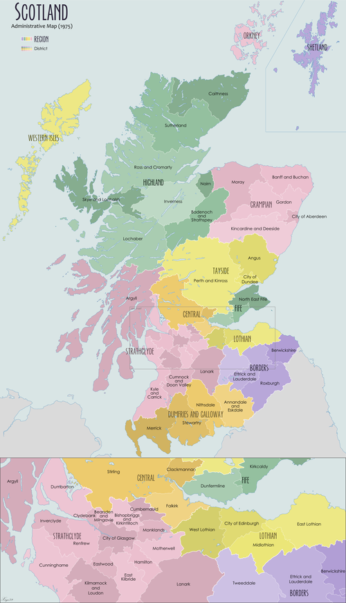 | |
| Central Region | ||
| Dumfries and Galloway | ||
| Fife | ||
| Grampian | ||
| Highland | ||
| Lothian | ||
| Strathclyde | ||
| Tayside | ||
| Island areas1 | ||