Huttig, Arkansas
Huttig is a city in Union County, Arkansas, United States. The population was 597 at the 2010 census.
Huttig, Arkansas | |
|---|---|
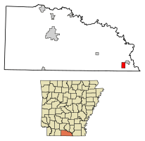 Location of Huttig in Union County, Arkansas. | |
| Coordinates: 33°2′20″N 92°11′2″W | |
| Country | United States |
| State | Arkansas |
| County | Union |
| Area | |
| • Total | 3.08 sq mi (7.98 km2) |
| • Land | 2.98 sq mi (7.72 km2) |
| • Water | 0.10 sq mi (0.26 km2) |
| Elevation | 102 ft (31 m) |
| Population (2010) | |
| • Total | 597 |
| • Estimate (2019)[2] | 528 |
| • Density | 177.24/sq mi (68.43/km2) |
| Time zone | UTC-6 (Central (CST)) |
| • Summer (DST) | UTC-5 (CDT) |
| ZIP code | 71747 |
| Area code(s) | 870 |
| FIPS code | 05-34090 |
| GNIS feature ID | 0077345 |
Geography
Huttig is located at 33°2′20″N 92°11′2″W (33.038999, -92.183797).[3]
According to the United States Census Bureau, the city has a total area of 3.1 square miles (8.0 km2), of which 3.0 square miles (7.8 km2) is land and 0.1 square miles (0.26 km2) (3.25%) is water.
Demographics
| Historical population | |||
|---|---|---|---|
| Census | Pop. | %± | |
| 1910 | 1,240 | — | |
| 1920 | 1,261 | 1.7% | |
| 1930 | 1,386 | 9.9% | |
| 1940 | 1,379 | −0.5% | |
| 1950 | 1,038 | −24.7% | |
| 1960 | 936 | −9.8% | |
| 1970 | 822 | −12.2% | |
| 1980 | 976 | 18.7% | |
| 1990 | 831 | −14.9% | |
| 2000 | 731 | −12.0% | |
| 2010 | 597 | −18.3% | |
| Est. 2019 | 528 | [2] | −11.6% |
| U.S. Decennial Census[4] | |||
As of the census[5] of 2000, there were 731 people, 282 households, and 197 families residing in the city. The population density was 245.4 people per square mile (94.7/km2). There were 321 housing units at an average density of 107.8/sq mi (41.6/km2). The racial makeup of the city was 48.70% White, 48.43% Black or African American, 0.82% Native American, 0.14% Pacific Islander, 0.82% from other races, and 1.09% from two or more races. 1.50% of the population were Hispanic or Latino of any race.
There were 282 households, out of which 32.6% had children under the age of 18 living with them, 50.4% were married couples living together, 16.7% had a female householder with no husband present, and 29.8% were non-families. 28.0% of all households were made up of individuals, and 12.4% had someone living alone who was 65 years of age or older. The average household size was 2.59 and the average family size was 3.22.
In the city, the population was spread out, with 25.9% under the age of 18, 8.9% from 18 to 24, 29.4% from 25 to 44, 22.7% from 45 to 64, and 13.1% who were 65 years of age or older. The median age was 36 years. For every 100 females, there were 96.0 males. For every 100 females age 18 and over, there were 88.9 males.
The median income for a household in the city was $25,284, and the median income for a family was $32,000. Males had a median income of $31,375 versus $18,056 for females. The per capita income for the city was $12,215. About 16.1% of families and 16.2% of the population were below the poverty line, including 23.1% of those under age 18 and 11.3% of those age 65 or over.
Education
Public education for elementary and secondary school students is provided by the Strong–Huttig School District, which leads to graduation from Strong High School.
It was served by Huttig School District, which operated Huttig Elementary School and Huttig High School.[6] On July 1, 2004, it consolidated with the Strong School District to form the Strong-Huttig School District.[7]
Notable people
- Daisy Bates—civil rights activist
- Floyd Cramer—American Hall of Fame pianist
References
- "2019 U.S. Gazetteer Files". United States Census Bureau. Retrieved June 30, 2020.
- "Population and Housing Unit Estimates". United States Census Bureau. May 24, 2020. Retrieved May 27, 2020.
- "US Gazetteer files: 2010, 2000, and 1990". United States Census Bureau. 2011-02-12. Retrieved 2011-04-23.
- "Census of Population and Housing". Census.gov. Retrieved June 4, 2015.
- "U.S. Census website". United States Census Bureau. Retrieved 2008-01-31.
- Home. Huttig School District. February 4, 2004. Retrieved on May 27, 2018.
- "ConsolidationAnnex_from_1983.xls." Arkansas Department of Education. Retrieved on May 26, 2018.
Municipalities and communities of Union County, Arkansas, United States | ||
|---|---|---|
| Cities | 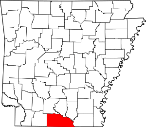 Map of Arkansas highlighting Union County | |
| Town | ||
| Unincorporated communities | ||