Haveli District
Haveli District (Urdu: ضلع حویلی) is the 9th districts of Azad Jammu and Kashmir, Pakistan. It was separated from the Bagh District on 1 July 2009.[1] It has a population of 152,124 according to the 2017 Census.[2]
Haveli حویلی | |
|---|---|
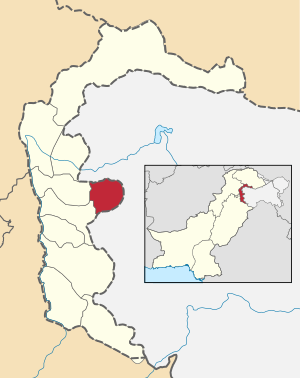 Pakistani district map shows Azad Kashmir (in white) with Haveli highlighted (in yellow). | |
| Country | Pakistan |
| Province | Azad Jammu and Kashmir |
| Headquarters | Forward Kahuta |
| Area | |
| • Total | 598 km2 (231 sq mi) |
| Population (2017) | |
| • Total | 152,124 |
| • Density | 268/km2 (690/sq mi) |
| Time zone | UTC+5 (PST) |
Administration
It is divided into three tehsils – Forward Kahuta (Haveli tehsil),[3] Khursheedabad (Kurshid Abad) and Mumtazabad. It has one municipal corporation, Forward Kahuta. There are 12 Union Councils in Haveli district consisting of 95 villages.
Geography
Haveli is situated at a high altitude of approximately 8000 feet above sea level. Heavy snowfall occurs regularly through the year. Darra Haji Peer, Lasdana, Sindhgala, Neel Kunth, Aliabad, sheraziabad, Kalamula, Jabbi Syedan are famous tourist Places Badori is the highest peaks.
Education
According to the Alif Ailaan Pakistan District Education Rankings 2017, Haveli is ranked 33 out of 148 districts in education. For facilities and infrastructure, the district is ranked 146 out of 148.[4]
References
- "District Haveli (Kahutta)". Government of Azad Jammu & Kashmir. Archived from the original on 8 April 2014. Retrieved 6 July 2013.
- "Census 2017: AJK population rises to over 4m". The Nation. Retrieved 2017-09-01.
- "Azad Kashmir – List of Tehsils, Districts and Divisions". politicpk.com. Retrieved 30 October 2018.
- "Individual district profile link, 2015". Alif Ailaan. Retrieved 2015-05-06.
Provincial capital: Muzaffarabad | ||
| Muzaffarabad | 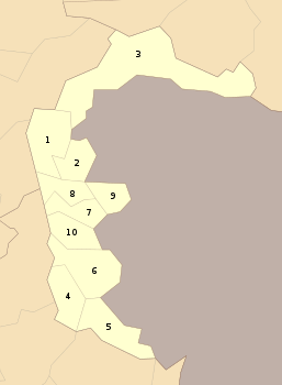 | |
| Poonch | ||
| Mirpur | ||