Grade II* listed buildings in Waveney
There are over 20,000 Grade II* listed buildings in England. This page is a list of these buildings in the district of Waveney in Suffolk.
Waveney
| Name | Location | Type | Completed [note 1] | Date designated | Grid ref.[note 2] Geo-coordinates |
Entry number [note 3] | Image |
|---|---|---|---|---|---|---|---|
| Brook Farmhouse | All Saints and St. Nicholas, South Elmham | Farmhouse | Early to mid 16th century | 27 April 1987 | TM3205082726 52°23′36″N 1°24′33″E |
1352625 |  |
| The Elms | All Saints, All Saints and St. Nicholas, South Elmham | Farmhouse | 15th century | 16 March 1972 | TM3325182488 52°23′26″N 1°25′36″E |
1352623 | |
| Whaley's | All Saints, All Saints and St. Nicholas, South Elmham | Farmhouse | Mid to late 16th century | 27 April 1987 | TM3394682489 52°23′25″N 1°26′12″E |
1032000 | |
| White House | All Saints and St. Nicholas, South Elmham | Farmhouse | c. 1600 | 1 September 1953 | TM3417582929 52°23′39″N 1°26′26″E |
1284035 | |
| Church of St John the Baptist | Barnby | Parish Church | Medieval | 17 April 1986 | TM4807389938 52°27′04″N 1°38′58″E |
1032106 | _-_geograph.org.uk_-_591735.jpg) Church of St John the Baptist |
| Ashmans Hall | Barsham | Country House | c. 1820 | 1 September 1953 | TM4128289735 52°27′08″N 1°32′58″E |
1032032 | |
| Northgate House | Beccles | House | 18th century | 16 March 1948 | TM4216290654 52°27′36″N 1°33′47″E |
1205862 | |
| Church of St Michael | Benacre | Parish Church | Medieval | 17 April 1986 | TM5116284460 52°24′02″N 1°41′27″E |
1032110 |  Church of St Michael |
| Church of St Margaret | Stoven, Brampton with Stoven | Tower | Medieval | 1 September 1953 | TM4479281610 52°22′40″N 1°35′43″E |
1032100 | _St_Margaret's_Church_-_geograph.org.uk_-_68600.jpg) Church of St Margaret |
| Ollands and The Gables | St John's Rd, Bungay | Houses | Post 1654 | 9 May 1949 | TM3409689176 52°27′01″N 1°26′37″E |
1275692 | |
| Roman Catholic Church of St Edmund | Bungay | Roman Catholic Church | 1889-1901 | 5 March 1998 | TM3369589680 52°27′18″N 1°26′17″E |
1376754 | .jpg) Roman Catholic Church of St Edmund |
| Rose Hall | Upper Olland St, Bungay | House | 1739 | 9 May 1949 | TM3371689316 52°27′06″N 1°26′17″E |
1275077 | |
| Trinity Hall | Staithe Rd, Bungay | House | 18th century | 9 May 1949 | TM3388189756 52°27′20″N 1°26′27″E |
1216991 | |
| Church of St Peter | Carlton Colville | Parish Church | Medieval | 17 April 1986 | TM5100090143 52°27′05″N 1°41′33″E |
1352577 | .jpg) Church of St Peter |
| Church of St Bartholomew | Corton | Parish Church | Medieval | 27 November 1954 | TM5384498062 52°31′17″N 1°44′25″E |
1352637 |  Church of St Bartholomew |
| Church of St Mary | Flixton, The Saints | Parish Church | Before 1086 | 1 September 1953 | TM3121186693 52°25′45″N 1°23′58″E |
1031989 |  Church of St Mary |
| Dovecote at Flixton Hall | Flixton, The Saints | Dovecote | Early 17th century | 1 September 1953 | TM3049285903 52°25′21″N 1°23′18″E |
1031986 | |
| Hill Farmhouse | Flixton, The Saints | Farmhouse | Early 16th century | 27 April 1987 | TM3140487151 52°26′00″N 1°24′10″E |
1031987 | |
| Church of St Mary the Virgin | Halesworth | Church | 14th century | 21 October 1949 | TM3860277364 52°20′33″N 1°30′05″E |
1267069 | 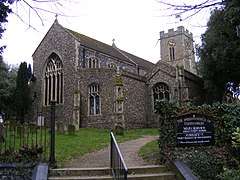 Church of St Mary the Virgin |
| Former Almshouses | Halesworth | Shop | 1949 | 21 October 1949 | TM3859077321 52°20′31″N 1°30′04″E |
1224060 | .jpg) Former Almshouses |
| Gothic House | 1, London Road, Halesworth | House | 1603-1625 | 21 October 1949 | TM3866577335 52°20′32″N 1°30′08″E |
1239856 | .jpg) Gothic House |
| The Social Club | Halesworth | Jettied House | 16th century | 21 October 1949 | TM3853777404 52°20′34″N 1°30′02″E |
1223564 |  The Social Club |
| Church of St Peter | Holton | Parish Church | Medieval | 1 September 1953 | TM4025677875 52°20′47″N 1°31′34″E |
1352566 | 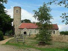 Church of St Peter |
| Church of St John the Baptist | Lound | Parish Church | Medieval | 27 November 1954 | TM5063498995 52°31′52″N 1°41′38″E |
1183409 | 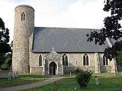 Church of St John the Baptist |
| Mutford Hall | Mutford | House | 19th century | 17 April 1986 | TM4809787512 52°25′45″N 1°38′53″E |
1352581 | .jpg) Mutford Hall |
| Manor House | Oulton | House | Late 16th century | 13 December 1949 | TM5254494862 52°29′35″N 1°43′08″E |
1292479 | |
| Church of St Margaret | Reydon | Parish Church | Medieval | 27 November 1954 | TM4909478189 52°20′43″N 1°39′21″E |
1032142 | 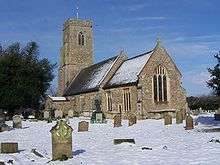 Church of St Margaret |
| Church of All Saints | Ringsfield | Parish Church | Medieval | 1 September 1953 | TM4031588429 52°26′27″N 1°32′04″E |
1032044 |  Church of All Saints |
| Hatton's Farmhouse | Rumburgh | Farmhouse | C20 | 23 April 1986 | TM3617981752 52°22′58″N 1°28′08″E |
1283698 | |
| Rushmere Hall | Rushmere | Farmhouse | Late 16th century | 17 April 1986 | TM4924587330 52°25′38″N 1°39′53″E |
1284310 | .jpg) Rushmere Hall |
| Hill Farmhouse | Shadingfield | Farmhouse | Early-Mid 16th century | 1 September 1953 | TM4346883516 52°23′44″N 1°34′38″E |
1352589 | |
| Moat Farmhouse | Shadingfield | Farmhouse | Mid 16th century | 1 September 1953 | TM4280485145 52°24′37″N 1°34′07″E |
1032132 | |
| Barn 30 Metres North of Manor Farmhouse | Shipmeadow | Barn | Late 19th century | 1 November 1988 | TM3790490322 52°27′32″N 1°30′01″E |
1352629 | |
| Church of St Bartholomew | Shipmeadow | Parish Church | Medieval | 1 September 1953 | TM3820289981 52°27′21″N 1°30′16″E |
1032004 | .jpg) Church of St Bartholomew |
| Barn 70 Metres East North East of Park Farmhouse | Somerleyton, Ashby and Herringfleet | Timber Framed Barn | 16th century | 29 January 1987 | TM5040798202 52°31′27″N 1°41′24″E |
1284051 | |
| Church of St Mary | Somerleyton, Somerleyton, Ashby and Herringfleet | Parish Church | 15th century | 27 November 1954 | TM4930597211 52°30′57″N 1°40′23″E |
1183419 |  Church of St Mary |
| Herringfleet Marsh Mill | Herringfleet, Somerleyton, Ashby and Herringfleet | Drainage Mill | c. 1820 | 27 November 1954 | TM4654397625 52°31′14″N 1°37′58″E |
1183297 | |
| Kitchen Garden of Somerleyton Hall | Somerleyton Park, Somerleyton, Ashby and Herringfleet | Garden | c. 1846 | 29 January 1987 | TM4923997979 52°31′21″N 1°40′21″E |
1031936 | |
| Somerleyton Hall | Somerleyton Hall, Somerleyton, Ashby and Herringfleet | Country House | 16th century | 29 January 1987 | TM4928397769 52°31′15″N 1°40′23″E |
1198046 | |
| Stable Court to Somerleyton Hall | Somerleyton Park, Somerleyton, Ashby and Herringfleet | Courtyard | 1846 | 29 January 1987 | TM4930397834 52°31′17″N 1°40′24″E |
1352646 | |
| Church Farmhouse | Sotherton | Farmhouse | Mid 16th century | 1 September 1953 | TM4415679538 52°21′34″N 1°35′04″E |
1183173 | |
| Church of St Andrew | Sotherton | Parish Church | Medieval | 1 September 1953 | TM4412279484 52°21′32″N 1°35′02″E |
1352590 | 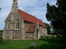 Church of St Andrew |
| Buckenham House | Southwold | House | Early 17th century addition | 21 April 1949 | TM5076376161 52°19′34″N 1°40′43″E |
1384375 | |
| Lloyds Bank | Southwold | Town House | 1716 | 21 April 1949 | TM5080176122 52°19′33″N 1°40′45″E |
1384386 | .jpg) Lloyds Bank |
| Manor House and Manor Gate including Forecourt Walls | Southwold | House | c. 1750 | 21 April 1949 | TM5069976219 52°19′36″N 1°40′40″E |
1384370 | .jpg) Manor House and Manor Gate including Forecourt Walls |
| Sutherland House | 56, High Street, Southwold | House | Remodelled early 19th century | 21 April 1949 | TM5066776289 52°19′39″N 1°40′38″E |
1384369 | |
| Church of St Peter | Spexhall | Parish Church | 12th century | 1 September 1953 | TM3783280175 52°22′05″N 1°29′32″E |
1032046 | 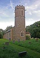 Church of St Peter |
| The Huntsman and Hounds | Stone Street, Spexhall | Timber Framed House | Mid 16th century | 1 September 1953 | TM3823582638 52°23′24″N 1°29′59″E |
1032051 | .jpg) The Huntsman and Hounds |
| Church of St John the Baptist | St John, Ilketshall | Parish Church | Medieval | 1 September 1953 | TM3601887563 52°26′06″N 1°28′15″E |
1032020 | .jpg) Church of St John the Baptist |
| Church of St Lawrence | St Lawrence, Ilketshall | Parish Church | 13th century | 1 September 1953 | TM3677586377 52°25′27″N 1°28′52″E |
1197944 | 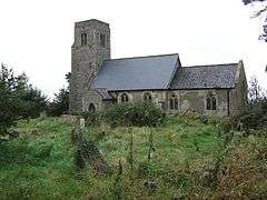 Church of St Lawrence |
| Boundary Farmhouse | St Margaret, Ilketshall | Farmhouse | Early 16th century | 1 September 1953 | TM3563883460 52°23′54″N 1°27′44″E |
1032023 | |
| Rookery Farmhouse | St Margaret's Green, St Margaret, South Elmham | Farmhouse | 16th century | 1 September 1953 | TM3238683467 52°23′59″N 1°24′52″E |
1198346 | |
| Church of St Mary | South Elmham St. Mary, otherwise Homersfield | Parish Church | 12th century | 1 September 1953 | TM2855985398 52°25′08″N 1°21′35″E |
1031994 |  Church of St Mary |
| Church of St Peter | St Peter, South Elmham | Parish Church | Norman | 1 September 1953 | TM3359584809 52°24′41″N 1°26′00″E |
1283860 |  Church of St Peter |
| St Peter's Hall | St Peter, South Elmham | House | 19th century | 1 September 1953 | TM3360085342 52°24′58″N 1°26′01″E |
1031979 |  St Peter's Hall |
| Uggeshall Hall | Uggeshall | Farmhouse | C16-C17 | 17 March 1986 | TM4568681510 52°22′35″N 1°36′30″E |
1183331 | |
| Beacon Farmhouse | Westhall | Farmhouse | Mid 16th century | 1 September 1953 | TM4192881381 52°22′37″N 1°33′11″E |
1352610 | |
| Slough Farmhouse | Westhall | Farmhouse | Mid 16th century | 23 April 1986 | TM3947483078 52°23′36″N 1°31′06″E |
1198991 | |
| Weston Hall | Weston | Country House | Late 16th century | 1 September 1953 | TM4259087143 52°25′42″N 1°34′01″E |
1032008 | |
| Manor Farmhouse | Wissett | Farmhouse | Early 16th century | 23 April 1986 | TM3608579678 52°21′51″N 1°27′58″E |
1032067 | |
| The Grange | Wissett | House | 16th century | 1 September 1953 | TM3634279495 52°21′45″N 1°28′11″E |
1199370 | |
| Church of All Saints | Worlingham | Parish Church | Medieval | 27 June 1986 | TM4451089836 52°27′06″N 1°35′49″E |
1182968 | 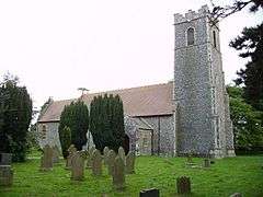 Church of All Saints |
| United Reformed Church | Wrentham | Chapel | 1778 | 27 November 1954 | TM4972882703 52°23′07″N 1°40′06″E |
1032152 | _Congregational_Chapel_-_geograph.org.uk_-_68614.jpg) United Reformed Church |
| Church of St Margaret and All Saints | Saxon Rd, Lowestoft | Parish Church | 13th century | 13 December 1949 | TM5386090496 52°27′12″N 1°44′05″E |
1207045 |  Church of St Margaret and All Saints |
| Church of St Peter | Gunton, Lowestoft | Parish Church | 12th century | 13 December 1949 | TM5422995752 52°30′01″N 1°44′39″E |
1208952 |  Church of St Peter |
| Church of St Peter and St John | Kirkley, Lowestoft | Parish Church | Early 15th century | 3 October 1977 | TM5405291567 52°27′46″N 1°44′19″E |
1207046 | 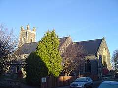 Church of St Peter and St John |
| Royal Norfolk and Suffolk Yacht Club | Lowestoft | Sailing Club | 1902-03 | 3 May 1979 | TM5480092618 52°28′19″N 1°45′01″E |
1207043 | |
| 36 High Street | Lowestoft | House | 1949-50 | 13 December 1949 | TM5516693932 52°29′01″N 1°45′24″E |
1292849 |  36 High Street |


Notes
- The date given is the date used by Historic England as significant for the initial building or that of an important part in the structure's description.
- Sometimes known as OSGB36, the grid reference is based on the British national grid reference system used by the Ordnance Survey.
- The "List Entry Number" is a unique number assigned to each listed building and scheduled monument by Historic England.
External links
![]()
This article is issued from Wikipedia. The text is licensed under Creative Commons - Attribution - Sharealike. Additional terms may apply for the media files.