Grade II* listed buildings in St Edmundsbury (borough)
There are over 20,000 Grade II* listed buildings in England. This page is a list of these buildings in the district of St Edmundsbury in Suffolk.
St. Edmundsbury
| Name | Location | Type | Completed [note 1] | Date designated | Grid ref.[note 2] Geo-coordinates |
Entry number [note 3] | Image |
|---|---|---|---|---|---|---|---|
| Bardwell Hall | Bardwell, St. Edmundsbury | House | 16th century | 14 July 1955 | TL9400272615 52°19′02″N 0°50′42″E |
1031309 |  Bardwell Hall |
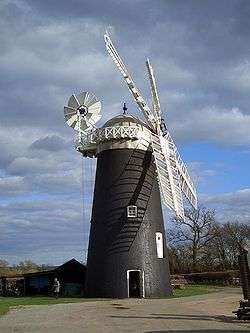
| Bardwell Windmill | Bardwell | Tower Mill | c. 1830 | 14 December 1983 | TL9410773806 52°19′41″N 0°50′50″E |
1181859 | |
| Church of All Saints | Barnardiston | Church | Pre 13th century | 19 December 1961 | TL7118448702 52°06′37″N 0°29′54″E |
1031773 | .jpg) Church of All Saints |
| Building 58, Former RAF Barnham Atomic Bomb Store | Barnham | Bomb Store | Built 1953-1954 | 24 June 2011 | TL8515579855 52°23′07″N 0°43′09″E |
1402411 | 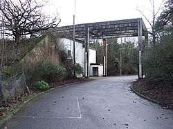 Building 58, Former RAF Barnham Atomic Bomb Store |
| Building 60, Former RAF Barnham Atomic Bomb Store | Barnham | Bomb Store | 1953-1954 | 24 June 2011 | TL8521979964 52°23′11″N 0°43′13″E |
1402497 |  |
| Building 61, Former RAF Barnham Atomic Bomb Store | Barnham | Bomb Store | 1953-1954 | 24 June 2011 | TL8525079857 52°23′07″N 0°43′14″E |
1402479 | |
| All Saints Church | Bradfield Combust with Stanningfield | Church | c. 1300 | 14 July 1955 | TL8922357309 52°10′54″N 0°45′59″E |
1228768 |  All Saints Church |
| Former Roman Catholic Chapel, 5 Metres East of Coldham Hall | Bradfield Combust with Stanningfield | Roman Catholic Chapel | c. 1800 | 14 July 1955 | TL8640455855 52°10′10″N 0°43′28″E |
1229769 | |
| Church of St Clare | Bradfield St. Clare | Church | Late 15th century | 14 July 1955 | TL9095557800 52°11′07″N 0°47′31″E |
1279340 |  Church of St Clare |
| St Andrew's Church | Brockley | Church | Early 14th century | 14 July 1955 | TL8273655553 52°10′05″N 0°40′14″E |
1279218 |  St Andrew's Church |
| Abbey House | 30, Angel Hill, Bury St. Edmunds | House | Late 18th century | 7 August 1952 | TL8556264166 52°14′40″N 0°43′00″E |
1141178 | |
| Ancient House & Oak House | 33a & 33b, Eastgate St, Bury St. Edmunds | House | 18th century | 7 August 1952 | TL8598664569 52°14′52″N 0°43′23″E |
1343595 | |
| Angel Hotel | 3, Angel Hill, Bury St. Edmunds | Inn | Before 1774 | 7 August 1952 | TL8549064186 52°14′41″N 0°42′56″E |
1141153 | |
| Baret House | 3, Chequer Sq, Bury St. Edmunds | House | 14th century | 7 August 1952 | TL8553664032 52°14′35″N 0°42′58″E |
1248046 | |
| Church of St Edmund | Bury St. Edmunds | Roman Catholic Church | 1837 | 7 August 1952 | TL8534063744 52°14′26″N 0°42′47″E |
1142338 | |
| Church of St John | Bury St. Edmunds | Parish Church | 1841 | 7 August 1952 | TL8528164677 52°14′57″N 0°42′46″E |
1135148 |  Church of St John |
| Dog and Partridge Inn | 29, Crown St, Bury St. Edmunds | Jettied House | Early 17th century | 7 August 1952 | TL8559363861 52°14′30″N 0°43′01″E |
1342750 |  Dog and Partridge Inn |
| Gateway and Walling to Number 13 the Fort Fronting the Road | Sicklesmere Rd, Bury St. Edmunds | Prison | 1803 | 7 August 1952 | TL8624363148 52°14′06″N 0°43′34″E |
1135179 | |
| Manchester House | 113, Northgate St, Bury St. Edmunds | House | Early 17th century | 7 August 1952 | TL8557664492 52°14′50″N 0°43′01″E |
1365774 | |
| Manson House | 111, Northgate St, Bury St. Edmunds | Timber Framed House | 16th century | 7 August 1952 | TL8554864583 52°14′53″N 0°43′00″E |
1365772 | |
| Moreton Hall School | Bury St. Edmunds | School | 1773 | 12 July 1972 | TL8693564497 52°14′49″N 0°44′13″E |
1022597 |  Moreton Hall School |
| Number 8, St Mary's Square and attached Wall | Bury St. Edmunds | Timber Framed House | Mid 17th century | 7 August 1952 | TL8579263786 52°14′27″N 0°43′11″E |
1135172 | |
| Ridleys | 35 & 36, Abbeygate St, Bury St. Edmunds | House | c. 1700 | 7 August 1952 | TL8546264204 52°14′41″N 0°42′54″E |
1328871 | |
| St Andrews Castle | St Andrew's St South, Bury St. Edmunds | House | Late C18/Early 19th century | 12 July 1972 | TL8513563966 52°14′34″N 0°42′37″E |
1245008 | |
| St Denys | 6, Honey Hill, Bury St. Edmunds | Timber Framed House | 15th century | 7 August 1952 | TL8570063928 52°14′32″N 0°43′06″E |
1022548 | |
| St Margarets House | Abbey Precinct, Bury St. Edmunds | House | Early 18th century | 7 August 1952 | TL8580163977 52°14′33″N 0°43′12″E |
1375562 | |
| St Michaels Close, Flats 1-11 (consecutive) | Bury St. Edmunds | Apartment | c. 1945 | 7 August 1952 | TL8549264657 52°14′56″N 0°42′57″E |
1022633 | |
| St Nicholas | 2, Hollow Rd, Bury St. Edmunds | Timber Framed House | 17th century | 7 August 1952 | TL8636564820 52°15′00″N 0°43′43″E |
1022540 |  St Nicholas |
| The Fox Inn | Bury St. Edmunds | Jettied House | 15th century | 7 August 1952 | TL8578264402 52°14′47″N 0°43′12″E |
1075223 |  The Fox Inn |
| The Priory Hotel | Bury St. Edmunds | Timber Framed House | Fragmentary older core | 7 August 1952 | TL8505665991 52°15′39″N 0°42′37″E |
1022595 | |
| Walls to the Priory Hotel | Bury St. Edmunds | Wall | 18th century | 7 August 1952 | TL8508865952 52°15′38″N 0°42′38″E |
1022596 | |
| The Rising Sun Public House | Bury St. Edmunds | Cross Wing House | 15th century | 7 August 1952 | TL8506864487 52°14′51″N 0°42′34″E |
1244921 |  The Rising Sun Public House |
| Turret House | 24, Westgate St, Bury St. Edmunds | House | Late 17th century | 7 August 1952 | TL8529763760 52°14′27″N 0°42′45″E |
1142315 | |
| Weavers Rest | 80, Southgate St, Bury St. Edmunds | Jettied House | Late 15th century | 7 August 1952 | TL8609463342 52°14′13″N 0°43′26″E |
1272141 | |
| 11 Abbeygate Street | Bury St. Edmunds | House | 18th century | 7 August 1952 | TL8536164212 52°14′42″N 0°42′49″E |
1021955 | |
| 28 and 28a, Abbeygate Street | Bury St. Edmunds | House | Early 17th century | 12 July 1972 | TL8547164233 52°14′42″N 0°42′55″E |
1328867 | |
| 31 and 32 Abbeygate Street | Bury St. Edmunds | Timber Framed House | 18th century | 7 August 1952 | TL8549064216 52°14′41″N 0°42′56″E |
1328869 | |
| 49, Abbeygate Street | Bury St. Edmunds | Apartment | Mid 19th century | 12 July 1972 | TL8536564171 52°14′40″N 0°42′49″E |
1141138 | |
| 56, Abbeygate Street | Bury St. Edmunds | Jettied House | Late 15th century | 7 August 1952 | TL8531664173 52°14′40″N 0°42′47″E |
1141143 | |
| 58, Abbeygate Street | Bury St. Edmunds | House | C20 | 7 August 1952 | TL8529264173 52°14′40″N 0°42′45″E |
1141145 | |
| 7 Northgate Street | Bury St. Edmunds | Jettied House | c. 1500 | 7 August 1952 | TL8556864410 52°14′48″N 0°43′00″E |
1022611 | |
| 112, Northgate Street | Bury St. Edmunds | House | Early/Mid 18th century | 7 August 1952 | TL8557164516 52°14′51″N 0°43′01″E |
1365773 | |
| 5 & 6, St Marys Square | Bury St. Edmunds | Timber Framed House | Early 16th century | 7 August 1952 | TL8579163824 52°14′28″N 0°43′11″E |
1135169 | |
| 6, Angel Hill | Bury St. Edmunds | House | Edwardian | 7 August 1952 | TL8549064241 52°14′42″N 0°42′56″E |
1141156 | |
| 31, 32 and 33, Angel Hill | Bury St. Edmunds | Apartment | 1972 | 12 July 1972 | TL8555664141 52°14′39″N 0°42′59″E |
1141179 | |
| 79, Guildhall Street | Bury St. Edmunds | Apartment | 1952 | 7 August 1952 | TL8524864026 52°14′36″N 0°42′43″E |
1363716 | |
| 80, Guildhall Street | Bury St. Edmunds | House | Early 18th century | 7 August 1952 | TL8524564046 52°14′36″N 0°42′43″E |
1363717 | |
| 38 Churchgate Street | Bury St. Edmunds | House | Earlier core | 7 August 1952 | TL8552364062 52°14′36″N 0°42′57″E |
1248210 | |
| 48, 49 and 49a Churchgate Street | Bury St. Edmunds | House | Late C18/Early 19th century | 12 July 1972 | TL8543064041 52°14′36″N 0°42′52″E |
1248214 | |
| 45 and 45a, Crown Street | Bury St. Edmunds | House | Early/Mid 18th century | 7 August 1952 | TL8556163986 52°14′34″N 0°42′59″E |
1342760 | |
| 93 and 95, Risbygate Street | Bury St. Edmunds | Jettied House | 14th century | 7 August 1952 | TL8501564490 52°14′51″N 0°42′31″E |
1244918 | |
| Church Cottages | Cavendish | House | 1966 | 10 February 1955 | TL8050646504 52°05′15″N 0°38′00″E |
1286156 |  Church Cottages |
| Church of All Saints | Chedburgh | Church | Medieval | 14 July 1955 | TL7961957481 52°11′11″N 0°37′34″E |
1186958 | 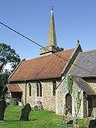 Church of All Saints |
| Moat Farmhouse | Chevington | House | c. 1580 | 25 August 1983 | TL8090558878 52°11′54″N 0°38′44″E |
1186965 | |
| Chapel Cottage | Clare | House | C20 | 19 December 1961 | TL7678146497 52°05′19″N 0°34′44″E |
1031736 |  Chapel Cottage |
| Church Farmhouse | Clare | Timber Framed House | 19 December 1961 | TL7690745493 52°04′46″N 0°34′49″E |
1285562 | | |
| Clare Castle | Clare | Castle | Mediaeval | 19 December 1961 | TL7706145212 52°04′37″N 0°34′56″E |
1031764 | |
| Netheridge | Clare | House | 17th century | 19 December 1961 | TL7678945105 52°04′34″N 0°34′42″E |
1180568 | |
| Red House | Clare | Timber Framed House | 17th century | 19 December 1961 | TL7680445116 52°04′34″N 0°34′43″E |
1031722 | |
| Riverside | Clare | House | 17th century | 19 December 1961 | TL7664344870 52°04′26″N 0°34′34″E |
1285380 | |
| Stour House | Clare | House | 17th century | 19 December 1961 | TL7669144903 52°04′27″N 0°34′36″E |
1031729 | |
| The Old Bear and Crown Hotel | Clare | Jettied House | 16th century | 19 December 1961 | TL7701145309 52°04′40″N 0°34′54″E |
1285511 |  The Old Bear and Crown Hotel |
| The Swan Inn | Clare | Inn | 15th century | 19 December 1961 | TL7693945293 52°04′40″N 0°34′50″E |
1031743 |  The Swan Inn |
| The Vicarage | Clare | House | 19th century | 19 December 1961 | TL7691245377 52°04′43″N 0°34′49″E |
1031746 | |
| Verandah House | Clare | Timber Framed House | 16th century | 19 December 1961 | TL7674244969 52°04′30″N 0°34′39″E |
1376689 | |
| 11–13 High Street | Clare | Timber Framed House | 19 December 1961 | TL7692745346 52°04′42″N 0°34′50″E |
1194690 |  11–13 High Street | |
| Culford Hall | Culford Park, Culford | Country House/School | Late 16th century | 14 July 1955 | TL8318770388 52°18′04″N 0°41′07″E |
1031236 | |
| Home Farm | Culford | Farmhouse | 19th century | 6 August 1997 | TL8361470031 52°17′52″N 0°41′29″E |
1245125 | |
| Church of St Mary | Denham | Church | Medieval | 14 July 1955 | TL7558561823 52°13′36″N 0°34′10″E |
1285509 |  Church of St Mary |
| Denston Hall | Denston | House | Early 16th century | 19 December 1961 | TL7586952450 52°08′32″N 0°34′07″E |
1031702 | |
| Church of St Mary | Depden | Church | 12th century | 19 December 1961 | TL7778156609 52°10′45″N 0°35′56″E |
1031669 |  Church of St Mary |
| Euston Hall | Euston Park, Euston | House | 1660s | 14 July 1955 | TL8983478620 52°22′22″N 0°47′14″E |
1376940 | |
| Stables to Euston Hall | Euston Park, Euston | House | Late 17th century | 14 July 1955 | TL8979278678 52°22′24″N 0°47′12″E |
1031286 | |
| The Temple | Euston Park, Euston | Banqueting House | 1746 | 14 July 1955 | TL9041278412 52°22′14″N 0°47′44″E |
1376924 |  The Temple |
| Church of St Catherine | Flempton | Church | Mid 14th century | 14 July 1955 | TL8130869933 52°17′51″N 0°39′27″E |
1031415 |  Church of St Catherine |
| Church of St Genevieve at Fornham Park | Fornham St. Genevieve | Church (ruined) | 14th century | 14 July 1955 | TL8399668359 52°16′57″N 0°41′45″E |
1376908 |  Church of St Genevieve at Fornham Park |
| Church of St Martin | Fornham St. Martin | Parish Church | 12th century | 14 July 1955 | TL8523366958 52°16′10″N 0°42′48″E |
1194364 |  Church of St Martin |
| Barn at Manor Farm | Great Barton | Aisled Barn | 13th century | 28 March 1985 | TL8905566503 52°15′51″N 0°46′08″E |
1031150 | |
| Conyers Green Farmhouse | Great Barton | Farmhouse | 15th century | 14 July 1955 | TL8862767545 52°16′25″N 0°45′48″E |
1031155 | |
| Church of St Mary | Great Bradley | Church | 12th century | 19 December 1961 | TL6742553170 52°09′05″N 0°26′45″E |
1181580 |  Church of St Mary |
| Church of SS Peter and Paul | Livermere Park, Great Livermere | Church (ruined) | 13th century | 14 July 1955 | TL8817671857 52°18′45″N 0°45′33″E |
1031249 |  Church of SS Peter and Paul |
| Church of All Saints | Great Thurlow | Church | Norman | 19 December 1961 | TL6808250333 52°07′33″N 0°27′14″E |
1031676 |  Church of All Saints |
| Great Thurlow Hall | Great Thurlow | House | 18th century | 19 December 1961 | TL6812050266 52°07′30″N 0°27′16″E |
1181879 |  Great Thurlow Hall |
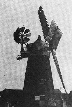
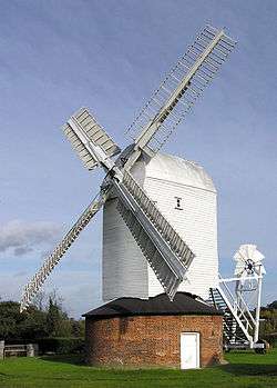
| Great Thurlow Windmill | Great Thurlow | Smock Mill | C18-C19 | 20 May 1974 | TL6715349975 52°07′22″N 0°26′25″E |
1376729 | 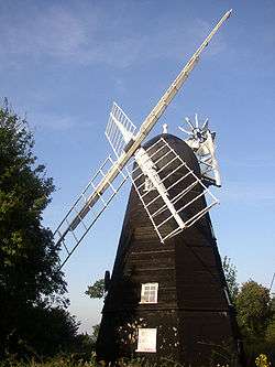 Great Thurlow Windmill |
| Church of St Mary | Great Wratting | Church | 13th century | 19 December 1961 | TL6880348189 52°06′23″N 0°27′48″E |
1031644 |  Church of St Mary |
| Church of St Edmund | Hargrave | Church | Medieval | 14 July 1955 | TL7667360841 52°13′03″N 0°35′05″E |
1186976 |  Church of St Edmund |
| Anne of Cleves House | Haverhill | Jettied House | Early 16th century | 26 June 1952 | TL6756045068 52°04′43″N 0°26′37″E |
1375508 |  Anne of Cleves House |
| Church of St Mary | Haverhill | Church | 13th century | 26 June 1952 | TL6715345520 52°04′58″N 0°26′17″E |
1375520 |  Church of St Mary |
| Old Independent Church | Haverhill | Congregational Chapel | 1884 | 9 May 1973 | TL6751045161 52°04′46″N 0°26′35″E |
1375509 | |
| Langleys Newhouse | Hawkedon | Timber Framed House | 16th century | 19 December 1961 | TL8041953834 52°09′12″N 0°38′09″E |
1182095 | |
| Church of St Peter | Hepworth | Parish Church | 13th century | 14 July 1955 | TL9874874854 52°20′09″N 0°54′57″E |
1031214 |  Church of St Peter |
| Church of St Leonard | Horringer | Church | Medieval | 14 July 1955 | TL8258162021 52°13′34″N 0°40′18″E |
1298948 |  Church of St Leonard |
| Church of All Saints | Hundon | Church | Early 14th century | 19 December 1961 | TL7386648742 52°06′35″N 0°32′15″E |
1182185 |  Church of All Saints |
| Thatchers Hall | Hundon | Jettied House | 15th century | 19 December 1961 | TL7376248844 52°06′38″N 0°32′10″E |
1182332 | |
| Church of St Mary | Ickworth | Church | Medieval | 14 July 1955 | TL8124861115 52°13′06″N 0°39′07″E |
1187001 | |
| Church of St Bartholomew | Ingham | Parish Church | Pre 1300 | 14 July 1955 | TL8552570546 52°18′06″N 0°43′10″E |
1031246 |  Church of St Bartholomew |
| Dover House and Garden Wall Adjoining on West | Stow Rd, Ixworth | Farmhouse | 15th century | 11 July 1983 | TL9315770252 52°17′47″N 0°49′52″E |
1031458 | |
| Stable to Pickerel Inn | Ixworth | Garage | C20 | 14 July 1955 | TL9325670421 52°17′52″N 0°49′58″E |
1376845 | |
| Water Mill and Mill House | Ixworth | Mill House | Early 17th century | 14 July 1955 | TL9274671094 52°18′15″N 0°49′32″E |
1376833 | |
| Ketton House | Kedington | House | Early 18th century | 19 December 1961 | TL7082346425 52°05′23″N 0°29′31″E |
1031633 | |
| Church of St Lawrence | Lackford | Church | Medieval | 14 July 1955 | TL7976470283 52°18′04″N 0°38′06″E |
1180661 |  Church of St Lawrence |
| Church of St Mary | Lidgate | Church | 13th century | 19 December 1961 | TL7206058159 52°11′41″N 0°30′57″E |
1376756 |  Church of St Mary |
| John-o-Lidgates House | Lidgate | Timber Framed House | 16th century | 19 December 1961 | TL7213957874 52°11′32″N 0°31′01″E |
1182635 | |
| Almshouses | Little Thurlow | Almshouses | 1618 | 19 December 1961 | TL6764051418 52°08′08″N 0°26′53″E |
1265476 |  Almshouses |
| Church of St Peter | Little Thurlow | Church | Early 14th century | 19 December 1961 | TL6796751188 52°08′00″N 0°27′10″E |
1227189 | 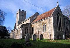 Church of St Peter |
| Lavender Cottage | Little Thurlow | Jettied House | 16th century | 19 December 1961 | TL6777150761 52°07′47″N 0°26′59″E |
1227312 | |
| The Olde School House | Little Thurlow | House | 1961 | 19 December 1961 | TL6777650914 52°07′52″N 0°26′59″E |
1227210 |  The Olde School House |
| Church of St Mary | Little Wratting | Church | 11th century | 19 December 1961 | TL6904347647 52°06′05″N 0°28′00″E |
1227380 |  Church of St Mary |
| Church of St Mary | Market Weston | Parish Church | 14th century | 14 July 1955 | TL9903878105 52°21′53″N 0°55′19″E |
1283638 |  Church of St Mary |
| Church of St Peter | Nowton | Parish Church | 12th century | 14 July 1955 | TL8633060467 52°12′39″N 0°43′33″E |
1194745 | 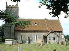 Church of St Peter |
| Nowton Hall | Nowton | Farmhouse | Early 16th century | 14 July 1955 | TL8610160464 52°12′39″N 0°43′21″E |
1031160 | |
| Barton Mere House | Barton Mere, Pakenham | House | Early 17th century | 14 July 1955 | TL9109366950 52°16′03″N 0°47′57″E |
1031462 | |
| Newe House | Pakenham | House | Earlier | 14 July 1955 | TL9310967257 52°16′10″N 0°49′43″E |
1181365 |  Newe House |
| Pakenham Windmill | Pakenham | Tower Mill | c. 1820 | 14 July 1955 | TL9309369414 52°17′20″N 0°49′47″E |
1376861 | |
| Watermill | Pakenham | Water Mill | 1814 | 11 July 1983 | TL9371869439 52°17′20″N 0°50′20″E |
1285022 |  Watermill |
| Watermill Farmhouse | Pakenham | Farmhouse | Early 17th century | 11 July 1983 | TL9367169482 52°17′22″N 0°50′18″E |
1376839 | |
| Church of St Mary | Poslingford | 12th century | 19 December 1961 | TL7696448182 52°06′13″N 0°34′57″E |
1265343 |  Church of St Mary | |
| Church of All Saints | Rede | Church | Earlier than 12th century | 14 July 1955 | 49°46′01″N 7°33′26″W | 1187006 |  Church of All Saints |
| Layers Breck Farmhouse | Blackthorpe, Rushbrooke with Rougham | Farmhouse | 15th century | 21 February 1972 | TL9011563184 52°14′02″N 0°46′57″E |
1031165 | |
| The Rookery | Rushbrooke with Rougham | House | 19th century | 28 March 1985 | TL9013463490 52°14′12″N 0°46′59″E |
1376992 | |
| Church of All Saints | Stanton | Parish Church | 14th century | 14 July 1955 | TL9658873443 52°19′26″N 0°53′00″E |
1376971 |  Church of All Saints |
| Church of St John | Stanton | Church (redundant) | 13th century | 14 July 1955 | TL9621373753 52°19′36″N 0°52′41″E |
1031224 |  Church of St John |
| Grundle House | Stanton | House | 18th century | 14 July 1955 | TL9675673104 52°19′15″N 0°53′08″E |
1285805 | |
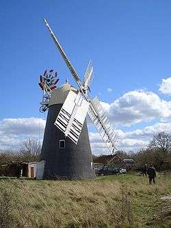
| Upthorpe Windmill | Stanton | Post Mill | 1807 | 10 June 1970 | TL9713373299 52°19′21″N 0°53′28″E |
1376972 | |
| Wyken Hall | Stanton | Timber Framed House | Late 16th century | 14 December 1983 | TL9656271606 52°18′27″N 0°52′55″E |
1031323 | |
| Cellarers Cottage | Stoke-by-Clare | Cross Wing House | C15-C16 | 19 December 1961 | TL7408243388 52°03′41″N 0°32′17″E |
1235566 | |
| Dovecote | Stanton | Dovecote | 15th century | 19 December 1961 | TL7405543376 52°03′41″N 0°32′15″E |
1235337 | |
| Green Farm Cottage | Stoke-by-Clare | Jettied House | 16th century | 19 December 1961 | TL7414743572 52°03′47″N 0°32′20″E |
1235447 | |
| Green Farmhouse | Stoke-by-Clare | House | pre 18th century | 19 December 1961 | TL7415043601 52°03′48″N 0°32′21″E |
1265089 | |
| Stoke College | Stoke-by-Clare | Country House | 1534 | 19 December 1961 | TL7413643168 52°03′34″N 0°32′19″E |
1265211 | |
| Church of St Andrew | Great Saxham, The Saxhams | Church | Medieval | 14 July 1955 | TL7884962812 52°14′04″N 0°37′04″E |
1031401 |  Church of St Andrew |
| Great Saxham Hall | Great Saxham, The Saxhams | Country House | Finished 1798 | 14 July 1955 | TL7907062725 52°14′01″N 0°37′15″E |
1181101 | |
| The Garden House, Great Saxham Hall | Great Saxham, The Saxhams | Garden House | Late 18th century | 14 July 1955 | TL7960462281 52°13′46″N 0°37′42″E |
1031410 | |
| Thelnetham Windmill | Thelnetham | Tower Mill | c. 1600 | 27 September 1984 | TM0110078967 52°22′19″N 0°57′10″E |
1031207 | |
| Church of St Andrew | Timworth | Parish Church | 13th century | 14 July 1955 | 49°46′01″N 7°33′26″W | 1194770 |  Church of St Andrew |
| Troston Hall | Troston | House | Early 17th century | 14 July 1955 | TL9017271808 52°18′41″N 0°47′18″E |
1031251 | |
| Church of St Mary | West Stow | Parish Church | 11th century | 14 July 1955 | TL8193370554 52°18′11″N 0°40′01″E |
1180464 |  Church of St Mary |
| Church of St Mary | Westley | Church | 1835 | 14 July 1955 | TL8237764518 52°14′55″N 0°40′13″E |
1205397 |  Church of St Mary |
| Church of St Petronilla | Whepstead | Church | Late 11th century or Early 12th century | 14 July 1955 | TL8327858238 52°11′31″N 0°40′48″E |
1230460 |  Church of St Petronilla |
| Badmondisfield Hall | Wickhambrook | House | 18th century | 19 December 1961 | TL7473257021 52°11′02″N 0°33′16″E |
1235891 | |
| Clopton Hall | Wickhambrook | Jettied House | 16th century | 19 December 1961 | TL7668554737 52°09′45″N 0°34′54″E |
1264858 | |
| Barn to Hall Farmhouse | Withersfield | Moat | 16th century | 19 December 1961 | TL6556447611 52°06′07″N 0°24′57″E |
1236069 | |
| Church of St Mary | Withersfield | Church | Late 13th century or early 14th century | 19 December 1961 | TL6512447764 52°06′13″N 0°24′34″E |
1235962 |  Church of St Mary |
| The Rectory | Withersfield | Vicarage | c. 1720 | 19 December 1961 | TL6522247755 52°06′12″N 0°24′39″E |
1236035 | |
| Church of St Leonard | Wixoe | Church | 12th century | 19 December 1961 | TL7180642994 52°03′31″N 0°30′17″E |
1236079 |  Church of St Leonard |


Notes
- The date given is the date used by Historic England as significant for the initial building or that of an important part in the structure's description.
- Sometimes known as OSGB36, the grid reference is based on the British national grid reference system used by the Ordnance Survey.
- The "List Entry Number" is a unique number assigned to each listed building and scheduled monument by Historic England.
External links
![]()
This article is issued from Wikipedia. The text is licensed under Creative Commons - Attribution - Sharealike. Additional terms may apply for the media files.