Grade II* listed buildings in South Northamptonshire
There are more thab 20,000 Grade II* listed buildings in England. This page is a list of these buildings in the district of South Northamptonshire in Northamptonshire.
South Northamptonshire
| Name | Location | Type | Completed [note 1] | Date designated | Grid ref.[note 2] Geo-coordinates |
Entry number [note 3] | Image |
|---|---|---|---|---|---|---|---|
| Adstone House and attached Garden Wall | Adstone, South Northamptonshire | House | Mid to late 17th century | 1 December 1951 | SP5942851530 52°09′32″N 1°07′58″W |
1040930 |  |
| Church of St Margaret | Alderton | Church | Late Perpendicular | 17 May 1960 | SP7404746909 52°06′56″N 0°55′12″W |
1190752 |  Church of St Margaret |
| Church of St Michael and All Angels | Ashton | Church | 14th century | 3 May 1968 | SP7652449977 52°08′34″N 0°52′59″W |
1190600 |  Church of St Michael and All Angels |
| 6 Round Town | Aynho | House | Late 15th century | 4 February 1969 | SP5141133170 51°59′41″N 1°15′09″W |
1192400 | |
| Church of St Mary | Blakesley | Church | c. 1300 | 17 May 1960 | SP6270550471 52°08′56″N 1°05′06″W |
1371622 |  Church of St Mary |
| Priory Farmhouse | Blakesley | Farmhouse | 15th century | 1 December 1951 | SP6265350454 52°08′56″N 1°05′09″W |
1040897 | |
| Church of St John the Baptist | Blisworth | Church | 13th century | 17 May 1960 | SP7252953410 52°10′27″N 0°56′27″W |
1371587 |  Church of St John the Baptist |
| Stoneacre | Blisworth | House | Early-mid 17th century | 1 December 1951 | SP7278753579 52°10′32″N 0°56′13″W |
1189162 | |
| Brackley Lodge (including Gate Piers) | Brackley | House | Early 18th century | 22 April 1950 | SP5852737018 52°01′43″N 1°08′54″W |
1189911 | _-_geograph.org.uk_-_1013228.jpg) Brackley Lodge (including Gate Piers) |
| Magdalen College Chapel of Saints John and James | Brackley | School chapel | 12th century | 22 April 1950 | SP5859837003 52°01′42″N 1°08′50″W |
1040573 | .jpg) Magdalen College Chapel of Saints John and James |
| Town Hall | Brackley | Town Hall | 1705-6 | 22 April 1950 | SP5843536809 52°01′36″N 1°08′59″W |
1190100 | Mar2006.jpg) Town Hall |
| 82–88 High Street | Brackley | Almshouse | 1633 | 22 April 1950 | SP5881437473 52°01′57″N 1°08′39″W |
1371804 | |
| Church of St Michael | Bradden | Church | 13th century | 14 December 1987 | SP6473748522 52°07′52″N 1°03′20″W |
1294406 |  Church of St Michael |
| Church of St Lawrence | Brafield on the Green | Church | 12th century | 3 May 1968 | SP8221559060 52°13′25″N 0°47′52″W |
1041597 |  Church of St Lawrence |
| Church of St Michael and All Angels | Bugbrooke | Parish Church | C13-C15 | 3 May 1968 | SP6740057311 52°12′36″N 1°00′54″W |
1041055 |  Church of St Michael and All Angels |
| The Dower House | Bugbrooke | House | Late 17th century | 3 May 1968 | SP6776157078 52°12′28″N 1°00′35″W |
1190311 | |
| Terrace Gardens | Castle Ashby Park, Castle Ashby | Gate | 1864 | 6 September 1988 | SP8639459225 52°13′28″N 0°44′12″W |
1189676 | |
| The Menagerie | Castle Ashby Park, Castle Ashby | House | 1761–74 | 3 May 1968 | SP8683059378 52°13′33″N 0°43′49″W |
1189885 | |
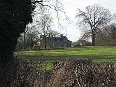
| Chacombe Priory | Chacombe | Country House | 16th century | 11 September 1953 | SP4885143887 52°05′28″N 1°17′18″W |
1041228 |  Chacombe Priory |
| The Manor House | Chipping Warden and Edgcote | Manor House | 16th century | 4 February 1969 | SP4995748779 52°08′06″N 1°16′18″W |
1293906 | |
| Church of St Peter | Cogenhoe, Cogenhoe and Whiston | Church | 13th century | 3 May 1968 | SP8301961045 52°14′29″N 0°47′08″W |
1041575 |  Church of St Peter |
| Church of St Luke | Cold Higham | Parish Church | 13th century | 17 May 1960 | SP6627053513 52°10′33″N 1°01′56″W |
1190319 | 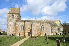 Church of St Luke |
| Bridge Number 65 | Grand Union Canal, Cosgrove | Canal Bridge | c. 1800 | 1 December 1951 | SP7928942742 52°04′39″N 0°50′40″W |
1190608 | %2C_Cosgrove%2C_Grand_Union_Canal_-_geograph.org.uk_-_478825.jpg) Bridge Number 65 |
| Church of St Peter and St Paul | Courteenhall | Church | C13-C17 | 3 May 1968 | SP7644952928 52°10′10″N 0°53′01″W |
1040983 |  Church of St Peter and St Paul |
| Courteenhall House and attached Offices | Courteenhall | Country House | 1791-3 | 23 August 1955 | SP7614053132 52°10′16″N 0°53′17″W |
1189193 |  Courteenhall House and attached Offices |
| Courteenhall House Stable Block and attached Coach Houses, Stables and Barn | Courteenhall | Stables | Mid 18th century | 23 August 1955 | SP7609652966 52°10′11″N 0°53′20″W |
1371591 | |
| The School and School House | Courteenhall | House | C20 | 3 May 1968 | SP7590353130 52°10′16″N 0°53′30″W |
1040984 | |
| Church of St Mary | Culworth | Church | Early 13th century | 4 February 1969 | SP5443546940 52°07′05″N 1°12′23″W |
1189875 |  Church of St Mary |
| Wall, Gatepiers and Gateway about 20m south of Church of St Mary | Culworth | Gate | C18/C19 | 4 July 1985 | SP5443646919 52°07′05″N 1°12′23″W |
1040493 | |
| Church of St Margaret of Antioch | Denton | Anchorite Cell | 13th century | 3 May 1968 | SP8379657983 52°12′49″N 0°46′30″W |
1041584 |  Church of St Margaret of Antioch |
| Church of St Nicholas | Eydon | Church | 13th century | 4 February 1969 | SP5411249981 52°08′44″N 1°12′38″W |
1040476 |  Church of St Nicholas |
| Abbey Lodge | Farthinghoe | House | 15th century | 4 February 1969 | SP5358439791 52°03′14″N 1°13′12″W |
1286510 | |
| Church of St Mary the Virgin | Gayton | Parish Church | 14th century | 17 May 1960 | SP7060254791 52°11′13″N 0°58′07″W |
1041071 |  Church of St Mary the Virgin |
| Church of St Mary the Virgin | Grafton Regis | Church | Early 13th century | 17 May 1960 | SP7589246922 52°06′56″N 0°53′35″W |
1040819 |  Church of St Mary the Virgin |
| The Chantry | Grafton Regis | House | 17th century | 1 December 1951 | SP7587046854 52°06′53″N 0°53′36″W |
1040820 | |
| Church of St Peter | Greatworth | Parish Church | 13th century | 18 March 1985 | SP5523642382 52°04′37″N 1°11′44″W |
1192679 |  Church of St Peter |
| Pair of Headstones about 5m south-west of South Porch of Church of St Peter | Greatworth | Gravestone | Late 18th century | 18 March 1985 | SP5523342372 52°04′37″N 1°11′44″W |
1371828 | |
| Church of St John the Baptist | Piddington, Hackleton | Church | 13th century | 3 May 1968 | SP8008954601 52°11′02″N 0°49′48″W |
1190138 |  Church of St John the Baptist |
| Church of St Mary | Horton, Hackleton | Church | 13th century | 3 May 1968 | SP8194154336 52°10′52″N 0°48′11″W |
1190174 | 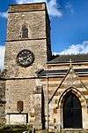 Church of St Mary |
| Church of St Peter and St Paul | Preston Deanery, Hackleton | Church | 12th century | 3 May 1968 | SP7884255679 52°11′37″N 0°50′53″W |
1041557 | |
| The Menagerie | Horton, Hackleton | Gate | Late 1750s | 3 May 1968 | SP8227053472 52°10′24″N 0°47′54″W |
1041554 |  The Menagerie |
| Church of All Saints | Harpole | Parish Church | C12-C15 | 3 May 1968 | SP6906160965 52°14′33″N 0°59′24″W |
1041038 |  Church of All Saints |
| Church of St John the Baptist | Hartwell | Church | Medieval | 3 May 1968 | SP7852650430 52°08′48″N 0°51′14″W |
1040826 |  Church of St John the Baptist |
| Astwell Castle | Helmdon | Manor House | 15th century | 11 September 1953 | SP6079444072 52°05′30″N 1°06′51″W |
1041132 | |
| Church of St Mary Magdalene | Helmdon | Church | 14th century | 9 February 1969 | SP5901143186 52°05′02″N 1°08′25″W |
1371508 |  Church of St Mary Magdalene |
| Astrop House | Astrop, Kings Sutton | House | c. 1740 | 31 August 1960 | SP5087836794 52°01′38″N 1°15′36″W |
1226127 | .jpg) Astrop House |
| Manor House | Kings Sutton | House | Early 17th century | 11 September 1953 | SP4979636051 52°01′14″N 1°16′33″W |
1226232 | .jpg) Manor House |
| The Courthouse | Kings Sutton | House | Late 16th century | 4 February 1969 | SP4986536065 52°01′15″N 1°16′29″W |
1226138 | |
| Church of St Martin | Litchborough | Parish Church | 13th century | 17 May 1960 | SP6326654257 52°10′59″N 1°04′34″W |
1371572 |  Church of St Martin |
| Church of St Mary the Virgin | Little Houghton | Church | C13-C15 | 3 May 1968 | SP8034059629 52°13′44″N 0°49′31″W |
1041558 |  Church of St Mary the Virgin |
| Little Houghton House and attached Office Wing | Little Houghton | House | c. 1825 | 6 September 1988 | SP8054659688 52°13′46″N 0°49′20″W |
1190269 | |
| Church of St Peter and St Paul | Maidford | Church | 13th century | 17 May 1960 | SP6097052539 52°10′04″N 1°06′36″W |
1371650 |  Church of St Peter and St Paul |
| Marston House | Marston St. Lawrence | Country House | C16-C17 | 11 September 1953 | SP5368342180 52°04′31″N 1°13′05″W |
1371491 | |
| Church of the Holy Cross | Milton Malsor | Church | Late 13th century to mid 14th century | 3 May 1968 | SP7366955558 52°11′36″N 0°55′25″W |
1040957 |  Church of the Holy Cross |
| Church of St Mary | Moreton Pinkney | Church | Late 12th century | 4 February 1969 | SP5740249052 52°08′12″N 1°09′46″W |
1293734 | .jpg) Church of St Mary |
| Church of St Peter and St Paul | Nether Heyford | Parish Church | 13th century | 3 May 1968 | SP6596058714 52°13′22″N 1°02′09″W |
1041021 |  Church of St Peter and St Paul |
| Church of St James | Newbottle | Church | 1764 | 4 February 1969 | SP5236136915 52°01′41″N 1°14′18″W |
1265911 |  Church of St James |
| Manor House | Great Purston, Newbottle | Manor House | 16th century | 4 February 1969 | SP5176139514 52°03′06″N 1°14′48″W |
1226244 |  Manor House |
| Manor House | Newbottle | Manor House | Early 16th century | 11 September 1953 | SP5237836961 52°01′43″N 1°14′17″W |
1226294 | |
| Church of Holy Cross | Pattishall | Parish Church | C11-C15 | 17 May 1960 | SP6711354295 52°10′58″N 1°01′11″W |
1371539 |  Church of Holy Cross |
| Church of St James the Great | Paulerspury | Church | 13th century | 17 May 1960 | SP7156845496 52°06′11″N 0°57′24″W |
1041108 |  Church of St James the Great |
| Church of St Bartholomew | Furtho, Potterspury | Church | 12th century | 17 June 1960 | SP7734343088 52°04′51″N 0°52′22″W |
1191073 | |
| Dovecote at Manor Farm | Furtho, Potterspury | Dovecote | Late 15th century | 18 May 1988 | SP7729943028 52°04′49″N 0°52′24″W |
1041652 |  Dovecote at Manor Farm |
| Stable Block at Wakefield Lodge and attached Walls, Outbuildings and Gatepiers | Potterspury | House | Mid 18th century | 1 December 1951 | SP7384142506 52°04′34″N 0°55′26″W |
1190683 | |
| Wakefield Lodge | Potterspury | Country House | 1748–1750 | 1 December 1951 | SP7375242550 52°04′35″N 0°55′31″W |
1371656 | |
| Church of St John the Baptist | Quinton | Church | Late Norman | 3 May 1968 | SP7767654330 52°10′54″N 0°51′55″W |
1371303 | .jpg) Church of St John the Baptist |
| Church of St Mary the Virgin | Roade | Church Hall | 1972 | 3 May 1968 | SP7573951867 52°09′36″N 0°53′39″W |
1294257 |  Church of St Mary the Virgin |
| Church of St Peter and St Paul | Rothersthorpe | Parish Church | 13th century | 3 May 1968 | SP7133456664 52°12′11″N 0°57′22″W |
1191724 | .jpg) Church of St Peter and St Paul |
| East Pavillion and attached Quadrant Colonnade | Stoke Park, Stoke Bruerne | House | c1629-35 | 1 December 1951 | SP7410948773 52°07′56″N 0°55′07″W |
1040911 |  East Pavillion and attached Quadrant Colonnade |
| West Pavillion and attached Quadrant Colonnade | Stoke Park, Shutlanger | Pavilion | c1629-35 | 1 December 1951 | SP7406648726 52°07′55″N 0°55′10″W |
1371608 | West Pavillion and attached Quadrant Colonnade |
| Church of St Mary the Virgin | Stoke Bruerne | Church | Late 12th century | 17 May 1960 | SP7406849838 52°08′31″N 0°55′09″W |
1040946 | .jpg) Church of St Mary the Virgin |
| Church of St James | Sulgrave | Church | Late Saxon | 4 February 1969 | SP5569045342 52°06′13″N 1°11′18″W |
1040418 | |
| Church of St James | Syresham | Church | 13th century | 4 February 1969 | SP6309041964 52°04′21″N 1°04′51″W |
1190438 |  Church of St James |
| Manor House | Thorpe Mandeville | Manor House | Early 18th century | 11 September 1953 | SP5331444965 52°06′02″N 1°13′23″W |
1041127 | |
| Church of St John the Baptist | Tiffield | Church | 13th century | 17 May 1960 | SP6991751629 52°09′31″N 0°58′46″W |
1040916 | |
| No 88 Watling St East (the Chantry House) and attached Forecourt Walls and Gateway | Towcester | House | 15th century | 1 August 1979 | SP6935648684 52°07′56″N 0°59′17″W |
1189997 |  No 88 Watling St East (the Chantry House) and attached Forecourt Walls and Gateway |
| Park Farmhouse | Handley, Towcester | Farmhouse | 1601 | 19 August 1976 | SP6732447102 52°07′05″N 1°01′05″W |
1189876 | |
| 157 Watling Street West | Towcester | House | Mid 18th century | 1 December 1951 | SP6936248581 52°07′52″N 0°59′17″W |
1040834 | |
| Church of St Mary | Wappenham | Church | 13th century | 17 May 1960 | SP6250045666 52°06′21″N 1°05′20″W |
1190507 |  Church of St Mary |
| The Laurels | Wappenham | Farmhouse | Early 18th century | 1 December 1951 | SP6269145747 52°06′23″N 1°05′10″W |
1293793 | |
| The Manor | Wappenham | Manor House | 1702 | 1 December 1951 | SP6246645682 52°06′21″N 1°05′22″W |
1190469 | |
| Church of St Mary | Warkworth | Church | 14th century | 4 February 1969 | SP4865140719 52°03′46″N 1°17′30″W |
1226297 | .jpg) Church of St Mary |
| Church of St Mary | Weedon Lois, Weston and Weedon | Church | c. 1100 | 17 May 1960 | SP6016046979 52°07′04″N 1°07′22″W |
1371888 |  Church of St Mary |
| Manor House Farmhouse, Outbuilding and Garden Wall | Plumpton, Weston and Weedon | Farmhouse | Early 17th century | 1 December 1951 | SP5991048433 52°07′51″N 1°07′34″W |
1293468 | |
| Weston Hall | Weston, Weston and Weedon | House | Late 17th century | 4 July 1985 | SP5913446916 52°07′03″N 1°08′16″W |
1040401 | |
| Church of St Mary | Whittlebury | Church | 13th century | 17 May 1960 | SP6896044230 52°05′32″N 0°59′41″W |
1371529 |  Church of St Mary |
| Church of St John the Evangelist | Wicken | Church | Medieval | 17 May 1960 | SP7451139500 52°02′56″N 0°54′54″W |
1371267 |  Church of St John the Evangelist |
| Wicken Country Hotel | Wicken | Country House | 1703 | 1 December 1951 | SP7431539465 52°02′55″N 0°55′04″W |
1041624 | |
| Manor House and attached Walls | Woodend | Manor House | Late 17th century | 1 December 1951 | SP6158049311 52°08′19″N 1°06′06″W |
1190155 | .jpg) Manor House and attached Walls |
| Church of St Andrew | Yardley Hastings | Church | 13th century | 3 May 1968 | SP8661657063 52°12′18″N 0°44′02″W |
1041535 | .jpg) Church of St Andrew |
| The Old Rectory | Yardley Hastings | House | 1935 | 3 May 1968 | SP8642057323 52°12′27″N 0°44′12″W |
1041541 | |


Notes
- The date given is the date used by Historic England as significant for the initial building or that of an important part in the structure's description.
- Sometimes known as OSGB36, the grid reference is based on the British national grid reference system used by the Ordnance Survey.
- The "List Entry Number" is a unique number assigned to each listed building and scheduled monument by Historic England.
External links
![]()
This article is issued from Wikipedia. The text is licensed under Creative Commons - Attribution - Sharealike. Additional terms may apply for the media files.