Grade II* listed buildings in South Holland
There are over 20,000 Grade II* listed buildings in England. This page is a list of these buildings in the district of South Holland in Lincolnshire.
South Holland
| Name | Location | Type | Completed [note 1] | Date designated | Grid ref.[note 2] Geo-coordinates |
Entry number [note 3] | Image |
|---|---|---|---|---|---|---|---|
| The Manor House | Crowland, South Holland | House | c. 1775 | 7 February 1967 | TF2398510260 52°40′33″N 0°10′03″W |
1359273 |  |
| The Peacock Guest House | Donington, South Holland | House | Late 17th century | 13 January 1988 | TF2089035683 52°54′18″N 0°12′14″W |
1064450 |  The Peacock Guest House |
| Wikes Farmhouse | Donington, South Holland | Farmhouse | 1680 | 13 January 1988 | TF2314835407 52°54′07″N 0°10′14″W |
1359286 | |
| 36 Church Street | Donington, South Holland | House | Mid 18th century | 7 February 1967 | TF2085235905 52°54′25″N 0°12′16″W |
1064448 | |
| Church of Holy Trinity | Gedney Hill, South Holland | Parish Church | Late 14th century | 30 June 1966 | TF3386811273 52°40′57″N 0°01′16″W |
1146771 | .jpg) Church of Holy Trinity |
| Cressy Hall | Gosberton, South Holland | House | 1695 | 7 February 1967 | TF2240430479 52°51′28″N 0°11′00″W |
1064460 | |
| Garnsgate Hall with Wall and Railings | Lutton, South Holland | House | Early 18th century | 30 June 1966 | TF4191222624 52°46′57″N 0°06′10″E |
1359230 |  Garnsgate Hall with Wall and Railings |
| Chapel of St James | Moulton Chapel, Moulton, South Holland | Chapel of Ease | 1722 | 7 February 1967 | TF2934818231 52°44′46″N 0°05′07″W |
1359293 |  Chapel of St James |
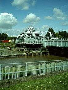
| Crosskeys Bridge | River Nene, Sutton Bridge, South Holland | Swing Bridge | 1897 | 11 January 1980 | TF4821721030 52°46′00″N 0°11′43″E |
1064536 | |
| East Lighthouse on Bank of River Nene | Sutton Bridge, South Holland | Lighthouse/House | C20 | 1 April 1980 | TF4931025717 52°48′30″N 0°12′49″E |
1281069 | .jpg) East Lighthouse on Bank of River Nene |
| Hydraulic Engine House | Sutton Bridge, South Holland | Hydraulic Engine House | 1897 | 11 January 1980 | TF4800620902 52°45′56″N 0°11′32″E |
1204796 |  Hydraulic Engine House |
| West Lighthouse on Bank of River Nene | River Nene, Sutton Bridge, South Holland | House | C20 | 30 June 1966 | TF4911625750 52°48′31″N 0°12′39″E |
1064537 | 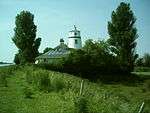 West Lighthouse on Bank of River Nene |
| Tower to Church of St James | Sutton St James, South Holland | Tower | 15th century | 26 November 1987 | TF3962518388 52°44′42″N 0°04′01″E |
1204853 |  Tower to Church of St James |
| Cley Hall | High St, Spalding, South Holland | Hotel | Mid 18th century | 29 December 1950 | TF2513922840 52°47′19″N 0°08′45″W |
1169039 | .jpg) Cley Hall |
| Constitutional Club | Spalding, South Holland | House | Mid 18th century | 29 December 1950 | TF2486222776 52°47′17″N 0°09′00″W |
1063999 | .jpg) Constitutional Club |
| East Elloe | High St., Spalding, South Holland | House | Late 18th century | 29 December 1950 | TF2521422981 52°47′24″N 0°08′41″W |
1359525 | |
| Garden Wall to No 21, High St | Spalding, South Holland | Garden Wall | 20 November 1975 | TF2510622816 52°47′18″N 0°08′47″W |
1063983 | | |
| Garden Wall to the South of No 4, Church St | Spalding, South Holland | Gate | 18th century | 20 November 1975 | TF2501122496 52°47′08″N 0°08′52″W |
1147578 | |
| Monk's House, Bourne Rd | Spalding, South Holland | House | Early 16th century | 29 December 1950 | TF2310022164 52°46′59″N 0°10′35″W |
1063993 | |
| Old Office Block of Land Settlement Association | Low Fulney, South Holland | House | Medieval | 19 December 1978 | TF2712222352 52°47′02″N 0°07′00″W |
1359567 | |
| Spalding High School for Girls | Spalding, South Holland | House | Mid 18th century | 29 December 1950 | TF2469822099 52°46′55″N 0°09′09″W |
1306654 | |
| The Grange, Pinchbeck Rd | Spalding, South Holland | House | Mid 18th century | 29 December 1950 | TF2481422913 52°47′22″N 0°09′02″W |
1063959 | |
| The Limes | Spalding, South Holland | House | Early 18th century | 29 December 1950 | TF2493822710 52°47′15″N 0°08′56″W |
1063971 |  The Limes |
| The Masters Lodge | Spalding, South Holland | House | 1721 | 29 December 1950 | TF2502522544 52°47′10″N 0°08′51″W |
1359534 | |
| The Sycamores | Spalding, South Holland | House | Early 19th century | 29 December 1950 | TF2494922728 52°47′16″N 0°08′55″W |
1307194 |  The Sycamores |
| The Vicarage | Spalding, South Holland | House | Early 19th century | 29 December 1950 | TF2509022462 52°47′07″N 0°08′48″W |
1064006 |  The Vicarage |
| Vicarage to Church of St Paul | Fulney, South Holland | Vicarage | 1877-1879 | 21 August 2007 | TF2610223817 52°47′50″N 0°07′52″W |
1392209 | |
| Welland Terrace | Spalding, South Holland | Terraced House | 18th century | 29 December 1950 | TF2481622388 52°47′05″N 0°09′03″W |
1359539 | .jpg) Welland Terrace |
| Westbourne House | Spalding, South Holland | House | Mid 18th century | 29 December 1950 | TF2482622129 52°46′56″N 0°09′02″W |
1359518 | .jpg) Westbourne House |
| Westbourne Lodge | Spalding, South Holland | House | Mid 18th century | 29 December 1950 | TF2477822044 52°46′54″N 0°09′05″W |
1359519 | |
| White Hart Hotel | Spalding, South Holland | Hotel | Mid 18th century | 29 December 1950 | TF2478622670 52°47′14″N 0°09′04″W |
1063953 |  White Hart Hotel |
| Willesby | Spalding, South Holland | House | Early 17th century | 29 December 1950 | TF2522323195 52°47′30″N 0°08′40″W |
1063991 | |
| Wisteria Lodge | Spalding, South Holland | House | 1792 | 29 December 1950 | TF2498022529 52°47′09″N 0°08′54″W |
1147529 |  Wisteria Lodge |
| Yew Lodge | Spalding, South Holland | Country House | Mid-Late 18th century | 29 December 1950 | TF2511222810 52°47′18″N 0°08′46″W |
1359524 | |
| 34 London Road | Spalding, South Holland | House | Early 18th century | 29 December 1950 | TF2477722185 52°46′58″N 0°09′05″W |
1063947 | |
| 1 Sheep Market | Spalding, South Holland | Smiths Cottage | c. 1230 | 29 December 1950 | TF2464622707 52°47′15″N 0°09′11″W |
1359545 | |
Notes
- The date given is the date used by Historic England as significant for the initial building or that of an important part in the structure's description.
- Sometimes known as OSGB36, the grid reference is based on the British national grid reference system used by the Ordnance Survey.
- The "List Entry Number" is a unique number assigned to each listed building and scheduled monument by Historic England.
External links
![]()
This article is issued from Wikipedia. The text is licensed under Creative Commons - Attribution - Sharealike. Additional terms may apply for the media files.