Grade II* listed buildings in South Bucks
There are over 20,000 Grade II* listed buildings in England. This page is a list of these buildings in the district of South Bucks in Buckinghamshire.
List
| Name | Location | Type | Completed [note 1] | Date designated | Grid ref.[note 2] Geo-coordinates |
Entry number [note 3] | Image |
|---|---|---|---|---|---|---|---|
| Africa House, Burke Lodge | Beaconsfield, South Bucks | House | C16/C17 | 19 May 1950 | SU9460290085 51°36′06″N 0°38′08″W |
1124572 | Africa House, Burke Lodge |
| Boathouse at Foot of Lake at Hall Barn | Hall Barn Estate, Beaconsfield | Boat House | Early 18th century | 24 April 1985 | SU9424088968 51°35′30″N 0°38′28″W |
1310579 |  |
| Hall Barn | Hall Barn Estate, Beaconsfield | Country House | Post 1651 | 19 May 1950 | SU9434289223 51°35′38″N 0°38′22″W |
1160418 | |
| Obelisk at Hall Barn | Hall Barn Estate, Beaconsfield | Obelisk | Early 18th century | 24 April 1985 | SU9387089182 51°35′37″N 0°38′47″W |
1310581 | |
| Temple of Venus at Hall Barn | Hall Barn Estate, Beaconsfield | Temple | Early 18th century | 19 May 1950 | SU9391688964 51°35′30″N 0°38′44″W |
1332613 | |
| Hall Place | Beaconsfield | House | 18th century | 19 May 1950 | SU9441290039 51°36′05″N 0°38′18″W |
1124518 | |
| Parish Church of St Mary and All Saints | Beaconsfield | Parish Church | Late 15th century | 19 May 1950 | SU9449090003 51°36′03″N 0°38′14″W |
1124547 | Parish Church of St Mary and All Saints |
| The Old Rectory (adjoining West Side of Churchyard) | Beaconsfield | Vicarage | 16th century | 19 May 1950 | SU9452889904 51°36′00″N 0°38′12″W |
1160916 | The Old Rectory (adjoining West Side of Churchyard) |
| Tomb of Edmund Waller South East of Parish Church of St Mary and All Saints | Beaconsfield | Obelisk | 1687 | 24 April 1985 | SU9452389980 51°36′03″N 0°38′12″W |
1160900 |  Tomb of Edmund Waller South East of Parish Church of St Mary and All Saints |
| Burnham Beeches Hotel: Entrance Gates and Curtain Walls | Burnham | Gate | 18th century | 24 April 1985 | SU9383983139 51°32′22″N 0°38′54″W |
1124496 | |
| Church of St Anne | Littleworth Common, Burnham | Church | 1866 | 23 September 1955 | SU9345086457 51°34′09″N 0°39′11″W |
1124522 |  Church of St Anne |
| Church of St Peter | Burnham | Parish Church | 13th century | 23 September 1955 | SU9305682397 51°31′58″N 0°39′35″W |
1124528 | 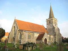 Church of St Peter |
| Nashdom | Burnham | House | Modern | 23 September 1955 | SU9199384292 51°33′00″N 0°40′29″W |
1332673 | |
| Footbridge across River Colne, to South of Denham Court | Denham Court, Denham | Footbridge | c. 1850 | 30 May 1986 | TQ0515187330 51°34′30″N 0°29′03″W |
1200391 | |
| Hills House | Denham | House | Late 17th century | 23 September 1955 | TQ0424387024 51°34′21″N 0°29′50″W |
1332704 | |
| Church of St James | Fulmer | Parish Church | 1610 | 23 September 1955 | SU9990485689 51°33′40″N 0°33′37″W |
1124420 |  Church of St James |
| Church of St James | Gerrards Cross | Bell Tower | 1859 | 23 September 1955 | TQ0009387924 51°34′53″N 0°33′25″W |
1124389 | 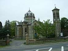 Church of St James |
| Shell House | Hedgerley | House | Late 17th century | 23 September 1955 | SU9701487673 51°34′46″N 0°36′05″W |
1124399 | |
| The Old Quaker House and Garden Wall | Hedgerley | House | 16th century | 23 September 1955 | SU9694187453 51°34′39″N 0°36′09″W |
1317834 | |
| Bridgefoot House | Iver | House | Early 18th century | 23 September 1955 | TQ0408981362 51°31′18″N 0°30′04″W |
1332738 | |
| Dairy in Grounds of Elk Meadows | Iver | Cottage Ornee | Early 19th century | 26 April 1985 | TQ0396482968 51°32′10″N 0°30′09″W |
1164777 | |
| Iver Grove | Shreding Green, Iver | House | 1722-1724 | 27 November 1954 | TQ0240681107 51°31′11″N 0°31′32″W |
1124384 | |
| Entrance Gates, Lamps and Lodges to Stoke Park | Stoke Poges | Gate Lodge | c. 1800 | 26 April 1985 | SU9746682332 51°31′53″N 0°35′47″W |
1124347 | |
| Gray's Monument | Stoke Poges | Sarcophagus | 1799 | 23 September 1955 | SU9778782667 51°32′04″N 0°35′30″W |
1124346 |  Gray's Monument |
| Stoke Park Bridge | Stoke Park, Stoke Poges | Bridge | 1798 | 23 September 1955 | SU9727382636 51°32′03″N 0°35′56″W |
1124358 |  Stoke Park Bridge |
| Balustrade from the Villa Borghese, Rome, to the South of Cliveden | Taplow | Balustrade | 1618 | 23 September 1955 | SU9103585125 51°33′28″N 0°41′18″W |
1332434 | 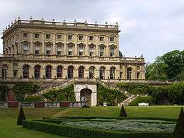 Balustrade from the Villa Borghese, Rome, to the South of Cliveden |
| Shell Fountain, Cliveden | Cliveden, Taplow, South Bucks | Shell Fountain | 1897 | 26 April 1985 | SU9108385565 51°33′42″N 0°41′15″W |
1125047 |  Shell Fountain, Cliveden |
| Stable Buildings at Cliveden | Cliveden, Taplow | Loggia | 1861 | 23 September 1955 | SU9096785266 51°33′32″N 0°41′21″W |
1125043 | |
| Langley Park including Quadrant Walls, Corner Towers, Pavilions and Orangery. | Langley Park, Wexham | Apartment | 1983 | 18 July 1972 | TQ0090981591 51°31′27″N 0°32′49″W |
1125028 | _p1.114_-_Langley_Park%2C_Buckinghamshire.jpg) Langley Park including Quadrant Walls, Corner Towers, Pavilions and Orangery. |
| Parish Church of St Mary | Wexham, South Bucks | Parish Church | 12th century | 26 April 1985 | SU9927181512 51°31′26″N 0°34′14″W |
1309053 |  Parish Church of St Mary |


Notes
- The date given is the date used by Historic England as significant for the initial building or that of an important part in the structure's description.
- Sometimes known as OSGB36, the grid reference is based on the British national grid reference system used by the Ordnance Survey.
- The "List Entry Number" is a unique number assigned to each listed building and scheduled monument by Historic England.
External links
![]()
This article is issued from Wikipedia. The text is licensed under Creative Commons - Attribution - Sharealike. Additional terms may apply for the media files.