Grade II* listed buildings in Plymouth
There are over 20,000 Grade II* listed buildings in England. This page is a list of these buildings in the district of Plymouth in Devon.
City of Plymouth
| Name | Location | Type | Completed [note 1] | Date designated | Grid ref.[note 2] Geo-coordinates |
Entry number [note 3] | Image |
|---|---|---|---|---|---|---|---|
| Amphitheatre in Grounds of Saltram House | Saltram Park, City of Plymouth | Garden Wall | Late 18th century | 1 May 1975 | SX5133355640 50°22′55″N 4°05′33″W |
1386231 | 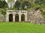 Amphitheatre in Grounds of Saltram House |
| Garden Temple (known as Fannys Bower) in Grounds of Saltram House | Saltram Park, City of Plymouth | Belvedere | Late 18th century | 1 May 1975 | SX5194155764 50°22′59″N 4°05′02″W |
1386235 | 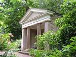 Garden Temple (known as Fannys Bower) in Grounds of Saltram House |
| Gardenhouse at Saltram House | Saltram Park, City of Plymouth | Summerhouse | c. 1772 | 29 March 1960 | SX5158755692 50°22′56″N 4°05′20″W |
1386234 | 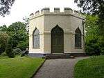 Gardenhouse at Saltram House |
| Orangery at Saltram House | Saltram Park, City of Plymouth | Orangery | 1773 | 29 March 1960 | SX5190555723 50°22′58″N 4°05′04″W |
1386238 | .jpg) Orangery at Saltram House |
| Stable Block at Saltram House | Saltram Park, City of Plymouth | Coachmans Cottage | Mid 18th century | 29 March 1960 | SX5210455541 50°22′52″N 4°04′53″W |
1386240 | 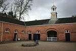 Stable Block at Saltram House |
| Gate Piers approximately 550 Metres South East of Saltram House | Saltram Park, City of Plymouth | Gate Pier | 1 May 1975 | SX5255855358 50°22′47″N 4°04′30″W |
1386236 |  | |
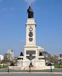
| Armada Memorial | Hoe, City of Plymouth | Commemorative Monument | 1888 | 1 May 1975 | SX4777953903 50°21′55″N 4°08′30″W |
1386461 | |
| Belmont House (Youth Hostel) Belmont Place | Stoke, City of Plymouth | Villa | 1820 | 1 May 1975 | SX4611155569 50°22′47″N 4°09′57″W |
1130060 | |
| Boringdon Arch (triumphal Arch) and Triumphal Arch Cottage and Outbuilding | Plympton, City of Plymouth | Wall | 1783 | 1 May 1975 | SX5278157796 50°24′06″N 4°04′22″W |
1386330 | |
| Building 13 (Receipt and Issue Magazine), RNOD, Bull Point | Royal Naval Ordnance Depot, Bull Point, City of Plymouth | Magazine | 1853 to 1857 | 17 April 2009 | SX4344657824 50°23′58″N 4°12′15″W |
1393253 | |
| Church of St Andrew, Stoke Damarel | Stoke, City of Plymouth | Parish Church | 15th century | 25 January 1954 | SX4633055001 50°22′29″N 4°09′45″W |
1386305 |  Church of St Andrew, Stoke Damarel |
| Church of St Aubyn including attached Walls and Walls to North and South | Devonport, City of Plymouth | Gate Pier | 1771 | 25 January 1954 | SX4545954697 50°22′19″N 4°10′28″W |
1130019 | |
| Church of St Budeaux | St Budeaux, City of Plymouth | Parish Church | C13/C14 | 25 January 1954 | SX4542859285 50°24′47″N 4°10′37″W |
1130049 | 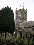 Church of St Budeaux |
| Church of St Edward, King of the West Saxons | Eggbuckland, City of Plymouth | Parish Church | c. 1430 | 25 January 1954 | SX4979757797 50°24′03″N 4°06′53″W |
1130025 | 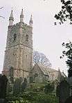 Church of St Edward, King of the West Saxons |
| Church of St Mary | Tamerton Foliot, City of Plymouth | Parish Church | 12th century | 25 January 1954 | SX4715260825 50°25′38″N 4°09′12″W |
1386426 |  Church of St Mary |
| Church of St Mary and All Saints | Plymstock, City of Plymouth | Parish Church | 15th century | 29 March 1960 | SX5172353012 50°21′30″N 4°05′09″W |
1330541 | 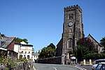 Church of St Mary and All Saints |
| Church of St Mary Blessed Virgin | Plympton, City of Plymouth | Church | 14th century | 29 March 1960 | SX5377156319 50°23′19″N 4°03′30″W |
1386222 | 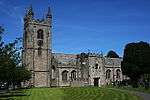 Church of St Mary Blessed Virgin |
| Church of St Maurice | Plympton St Maurice, City of Plymouth | Parish Church | 15th century | 29 March 1960 | SX5458255759 50°23′01″N 4°02′48″W |
1130037 | 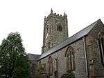 Church of St Maurice |
| Church of St Paul | Stonehouse, City of Plymouth | Anglican Church | 1831 | 25 January 1954 | SX4642453757 50°21′49″N 4°09′38″W |
1117102 | 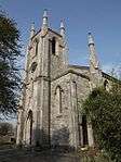 Church of St Paul |
| Covered Slip (S 180) | Devonport Dockyard, City of Plymouth | Slip Shed | 1814 | 13 August 1999 | SX4515154007 50°21′56″N 4°10′43″W |
1388431 |  Covered Slip (S 180) |
| Custom House | Barbican, City of Plymouth | Custom House | 1820 | 1 May 1975 | SX4818754223 50°22′06″N 4°08′10″W |
1386460 | 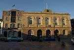 Custom House |
| Devonport High School for Boys | Stoke, City of Plymouth | School | 1998 | 9 November 1998 | SX4637954932 50°22′27″N 4°09′42″W |
1386309 | 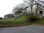 Devonport High School for Boys |
| Dockyard Museum, Former Office (SO 32) | Devonport Dockyard, City of Plymouth | Fireproof Building | c. 1780 | 13 August 1999 | SX4497254625 50°22′16″N 4°10′53″W |
1388408 | .jpg) Dockyard Museum, Former Office (SO 32) |
| Dockyard Wall Extending Approximately 300 Metres to South East Side Royal William Victualling Yard | Stonehouse, City of Plymouth | Wall | 1830-1831 | 13 August 1999 | SX4632353542 50°21′42″N 4°09′43″W |
1378537 | |
| Dovecote at Hardwick Farm | Hardwick, City of Plymouth | Dovecote | Late Medieval or 16th century | 29 March 1960 | SX5341055258 50°22′44″N 4°03′47″W |
1319610 | |
| Drake Statue | Hoe, City of Plymouth | Statue | 1884 | 1 May 1975 | SX4770053902 50°21′55″N 4°08′34″W |
1386462 |  Drake Statue |
| Education Offices (former Grammar School) | Plympton St Maurice, City of Plymouth | Local Government Office | 1952 | 23 April 1952 | SX5462255726 50°23′00″N 4°02′46″W |
1322035 | 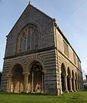 Education Offices (former Grammar School) |
| Eggbuckland Keep | City of Plymouth | Keep | Late 1860s to 1872 | 16 July 2004 | SX5000858107 50°24′13″N 4°06′43″W |
1390897 | |
| Elizabethan House Museum | Barbican, City of Plymouth | House | 1926 | 25 January 1954 | SX4825154057 50°22′00″N 4°08′06″W |
1386279 | 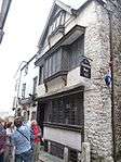 Elizabethan House Museum |
| Elliot Terrace, Numbers 1 to 8 including 6a and Walls and Gate Piers | Hoe, City of Plymouth | Terrace | Mid 19th century | 1 May 1975 | SX4751353953 50°21′56″N 4°08′43″W |
1386463 | 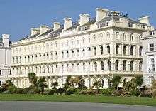 Elliot Terrace, Numbers 1 to 8 including 6a and Walls and Gate Piers |
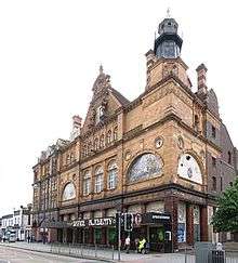
| Former Palace Theatre and Great Western Hotel | Stonehouse, City of Plymouth | Hotel | 1898 | 24 October 1974 | SX4694554396 50°22′10″N 4°09′13″W |
1386483 | |
| Former Royal Naval Hospital: the Quadrangle Centre, High St., the Quadrangle Centre Creykes, Gordon, Fellowes, Lyster and Sandon, Evans, Hornby, Dudding, Pryn and Norbury Court, Craigie Drive. | Stonehouse, City of Plymouth | House | Mid 1990s | 1 May 1975 | SX4659354661 50°22′18″N 4°09′31″W |
1113296 | |
| Former Royal Naval Hospital Water Tower | Stonehouse, City of Plymouth | Cistern | 1758-1780 | 1 May 1975 | SX4676154819 50°22′24″N 4°09′23″W |
1113325 | |
| HMS Drake Wardroom, Officers Quarters and Mess | Devonport, City of Plymouth | Officers Mess | 1898-1902 | 1 May 1975 | SX4499756685 50°23′22″N 4°10′55″W |
1386376 | |
| Hooe Manor | Plymstock, City of Plymouth | Apartment | 1960 | 29 March 1960 | SX5016352207 50°21′02″N 4°06′27″W |
1330563 | |
| Kings Hill Gazebo (S 186) | Devonport Dockyard, City of Plymouth | Gazebo | 1822 | 13 August 1999 | SX4516454042 50°21′57″N 4°10′42″W |
1388430 | |
| Manadon House | Crownhill, City of Plymouth | House | 16th century | 1 May 1975 | SX4799358366 50°24′20″N 4°08′26″W |
1386217 | |
| Morice Gate, Two Gatehouses (MO 39 and 65) and attached Dockyard Walls | Devonport Dockyard, City of Plymouth | Gate | 1720-1724 | 13 August 1999 | SX4496654893 50°22′24″N 4°10′54″W |
1378549 | |
| Mountbatten Tower | Plymstock, City of Plymouth | Coastal Battery | 1660s | 1 May 1975 | SX4864453251 50°21′35″N 4°07′45″W |
1386253 |  Mountbatten Tower |
| Mutley Baptist Church Including Spurgeon Hall and Caretakers Cottage | Mutley, City of Plymouth | House | 1907 | 4 June 1996 | SX4837955626 50°22′51″N 4°08′02″W |
1386261 | 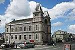 Mutley Baptist Church Including Spurgeon Hall and Caretakers Cottage |
| Naval 1914 to 1918 War Memorial | Hoe, City of Plymouth | War Memorial | 1920-1924 | 1 May 1975 | SX4774053937 50°21′56″N 4°08′32″W |
1386464 | 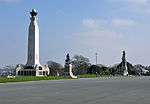 Naval 1914 to 1918 War Memorial |
| North Smithery (SO 23) | Devonport Dockyard, City of Plymouth | Blacksmiths Workshop | 1808 | 13 August 1999 | SX4486254618 50°22′15″N 4°10′59″W |
1388402 | |
| Number 1, The Crescent and attached Forecourt Wall and Railings | Hoe, City of Plymouth | Terraced House | c. 1833 | 25 January 1954 | SX4748054236 50°22′06″N 4°08′46″W |
1386444 | |
| Number 1 Dock and Basin and Number 2, 3 and 4 Docks and associated Bollards | Devonport Dockyard, City of Plymouth | Capstan | 1897 | 13 August 1999 | SX4473854573 50°22′14″N 4°11′05″W |
1388409 | |
| Number 12 the Painted Canvas Store (MO 46) | Devonport Dockyard, City of Plymouth | House | 1777 | 13 August 1999 | SX4487054880 50°22′24″N 4°10′59″W |
1378552 | |
| Number 16 Store the Powder House (MO 42) | Devonport Dockyard, City of Plymouth | Powder Magazine | 1744 | 13 August 1999 | SX4490554958 50°22′26″N 4°10′57″W |
1378553 | |
| Number 2 Store and Former Furbishers Shop (MO 68) | Devonport Dockyard, City of Plymouth | Carriage House | c. 1776 | 13 August 1999 | SX4485054781 50°22′21″N 4°10′59″W |
1378550 | |
| Number 4 Store (MO 70) | Devonport Dockyard, City of Plymouth | Ordnance Store | 1722-1723 | 13 August 1999 | SX4481654792 50°22′21″N 4°11′01″W |
1378551 | |
| Officers House Number 1 and attached Walls and Railings, Royal William Victualling Yard | Cremyll St, Stonehouse, City of Plymouth | Naval Officers House | 1830-1832 | 13 August 1999 | SX4628153548 50°21′42″N 4°09′45″W |
1378538 | |
| Officers House Number 2 and attached Walls and Railings, Royal William Victualling Yard | Cremyll St, Stonehouse, City of Plymouth7 | Naval Officers House | 1830-1832 | 13 August 1999 | SX4626453575 50°21′43″N 4°09′46″W |
1378539 | |
| Officers Terrace (SO 59) and attached Basement Area Railings | Devonport Dockyard, City of Plymouth | House | Early 19th century | 1 May 1975 | SX4495754540 50°22′13″N 4°10′54″W |
1378525 | |
| Old Custom House | Barbican, City of Plymouth | Merchants House | 1586 | 25 January 1954 | SX4814654174 50°22′04″N 4°08′12″W |
1386456 | |
| Pair of Gate Piers at Entrance to Boringdon Hall | Boringdon, City of Plymouth | Gate Pier | Late 17th century | 1 May 1975 | SX5394057744 50°24′05″N 4°03′24″W |
1330577 | |
| Pair of Gatepiers Approximately 550 Metres South East of Plym Bridge | Plympton, City of Plymouth | Gate Pier | Late 17th century | 1 May 1975 | SX5283258393 50°24′25″N 4°04′21″W |
1107443 | |
| Plym Bridge | Plympton, City of Plymouth | Road Bridge | 18th century | 25 January 1954 | SX5236558713 50°24′35″N 4°04′45″W |
1386329 | 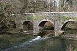 Plym Bridge |
| Plym Bridge (that Part in South Hams District) | City of Plymouth | Road Bridge | Earlier | 23 April 1952 | SX5236458714 50°24′35″N 4°04′45″W |
1162902 | Plym Bridge (that Part in South Hams District) |
| Railings, Piers and Gateway to Kings Hill Gazebo | Devonport Dockyard, City of Plymouth | Gate | 1822 | 13 August 1999 | SX4517654045 50°21′57″N 4°10′42″W |
1388429 | |
| Rear Retaining Wall Extending approximately 400 Metres, Royal William Victualling Yard | Stonehouse, City of Plymouth | Stonemasons Yard | 1827-1831 | 13 August 1999 | SX4618353491 50°21′40″N 4°09′50″W |
1378541 | |
| Remains of Castle | City of Plymouth | Keep | 12th century or early 13th century | 29 March 1960 | SX5448055755 50°23′01″N 4°02′54″W |
1129995 | |
| Royal Citadel Governors House and Steps to Doorways | The Barbican, City of Plymouth | Steps | Mid to Late C20 | 8 July 1998 | SX4800853878 50°21′54″N 4°08′18″W |
1067143 | |
| Royal Citadel Great Store | The Barbican, City of Plymouth | Barracks | 1844 | 8 July 1998 | SX4811453763 50°21′51″N 4°08′13″W |
1067144 | |
| Royal Marine Barracks Archway Block | Stonehouse, City of Plymouth | Guardhouse | 1867-1871 | 1 May 1975 | SX4636454053 50°21′59″N 4°09′42″W |
1117103 | |
| Royal Marine Barracks East Barrack Block and Forecourt Railings | Stonehouse, City of Plymouth | Barracks | 1781-1783 | 1 May 1975 | SX4645054068 50°21′59″N 4°09′37″W |
1117106 | |
| Royal Marine Barracks North Barrack Block and Attached Basement Railings | Stonehouse, City of Plymouth | Barracks | c. 1860 | 1 May 1975 | SX4639154128 50°22′01″N 4°09′40″W |
1244639 | |
| Royal Marine Barracks Officers Mess | Stonehouse, City of Plymouth | Courtyard | 1779-1785 | 1 May 1975 | SX4643853969 50°21′56″N 4°09′38″W |
1244640 | |
| Royal Marine Barracks South Block and Attached Basement Railings | Stonehouse, City of Plymouth | Railings | Late 19th century | 1 May 1975 | SX4640553976 50°21′56″N 4°09′40″W |
1244644 | |
| Royal Marine Barracks South West Block and Attached Front Basement Railings | Stonehouse, City of Plymouth | Apartment | 1907 | 1 May 1975 | SX4637453978 50°21′56″N 4°09′41″W |
1244642 | |
| Royal Marine Barracks the Longroom | Stonehouse, City of Plymouth | Assembly Rooms | 1760 | 1 May 1975 | SX4651653804 50°21′51″N 4°09′34″W |
1244646 | |
| Sherwell Church and associated Buildings Including Shelly Hall | City of Plymouth | Church Hall | 1864 | 18 November 1991 | SX4811355044 50°22′32″N 4°08′15″W |
1386295 | 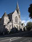 Sherwell Church and associated Buildings Including Shelly Hall |
| South Saw Mills (S 128, 148, 149, 150) | Devonport Dockyard, City of Plymouth | Fireproof Building | 1856-1859 | 13 August 1999 | SX4498654180 50°22′01″N 4°10′52″W |
1388413 | |
| South Smithery (building S 126) | Royal Naval Dockyard, City of Plymouth | Blacksmiths Workshop | 1771 | 4 March 2008 | SX4493554234 50°22′03″N 4°10′54″W |
1392692 | |
| St Dunstans Abbey and attached Road Frontage Walls | Stonehouse, City of Plymouth | Abbey | 1850 | 1 May 1975 | SX4693954980 50°22′29″N 4°09′14″W |
1386299 | |
| St Dunstans Abbey School and Attached Road Frontage Walls | Stonehouse, City of Plymouth | Abbey | 1850 | 1 May 1975 | SX4687954927 50°22′27″N 4°09′17″W |
1386300 | |
| St Michaels Lodge and Rear Basement Court Railings | Stoke, City of Plymouth | Villa | 1827 | 1 May 1975 | SX4588655129 50°22′33″N 4°10′07″W |
1130059 | |
| Steps Dwarf Walls Lamps and Retaining Wall to Gardens Fronting Officers Terrace | Devonport Dockyard, City of Plymouth | Wall | 1722 | 13 August 1999 | SX4488254834 50°22′22″N 4°10′58″W |
1378554 | |
| Plymouth Synagogue | City of Plymouth | Synagogue | 1762 | 25 January 1954 | SX4786954354 50°22′10″N 4°08′26″W |
1130015 | |
| Tarred Yarn Store | Devonport Dockyard, City of Plymouth | Storehouse | 1769 | 13 August 1999 | SX4521754200 50°22′02″N 4°10′40″W |
1378504 | |
| Tarring and Wheel House (S 136) and Tarred Yarn House (S 137) | Devonport Dockyard, City of Plymouth | Tar House | 1763 | 13 August 1999 | SX4520554238 50°22′03″N 4°10′41″W |
1378505 | |
| The Distillery Public House, former Coates Gin Distillery | Barbican, City of Plymouth | First Floor Hall House | c. 1500 | 25 January 1954 | SX4805354159 50°22′04″N 4°08′16″W |
1386410 | 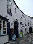 The Distillery Public House, former Coates Gin Distillery |
| The Esplanade Numbers 1 to 8 and Forecourt Walls and Railings | Hoe, City of Plymouth | Villa | 1836 | 25 January 1954 | SX4759853947 50°21′56″N 4°08′39″W |
1386468 | 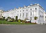 The Esplanade Numbers 1 to 8 and Forecourt Walls and Railings |
| The Guildhall | City of Plymouth | Guildhall | 1696 | 23 April 1952 | SX5439555697 50°22′59″N 4°02′58″W |
1244435 | 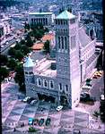 The Guildhall |
| The Officers Terrace (MO 63) and attached Railings, Rear Walls and Outbuildings | Devonport Dockyard, City of Plymouth | House | 1975 | 1 May 1975 | SX4491254833 50°22′22″N 4°10′56″W |
1378564 | |
| The Rectory | City of Plymouth | House | Late 19th century | 23 April 1952 | SX5454355671 50°22′58″N 4°02′50″W |
1244424 | |
| The Retreat | Plymstock, City of Plymouth | Detached House | Late 18th century | 29 March 1960 | SX5022452245 50°21′04″N 4°06′24″W |
1330566 | |
| The Scrieve Board (S 122) | Devonport Dockyard, City of Plymouth | Mould Loft | 1814-1821 | 13 August 1999 | SX4485954124 50°21′59″N 4°10′58″W |
1388417 | |
| Tudor Lodge | City of Plymouth | Merchants House | 17th century | 29 March 1960 | SX5443855672 50°22′58″N 4°02′56″W |
1244395 | |
| Walls and Bollards to Number 3 Basin | Devonport Dockyard, City of Plymouth | Wall | 1844-1848 | 13 August 1999 | SX4487455635 50°22′48″N 4°10′59″W |
1378569 | |
| White Yarn House (S 135) | Devonport Dockyard, City of Plymouth | Yarn House | 1763 | 13 August 1999 | SX4518554296 50°22′05″N 4°10′42″W |
1378503 | |
| 33 St Andrews Street | City of Plymouth | House | Late 16th century | 25 January 1954 | SX4794354301 50°22′08″N 4°08′22″W |
1386362 | 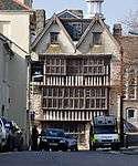 33 St Andrews Street |
| 36 New Street | Barbican, City of Plymouth | House | Early 17th century | 1 May 1975 | SX4821854066 50°22′01″N 4°08′08″W |
1386283 | |
| 17 New Street | Barbican, City of Plymouth | Jettied House | 1599 | 25 January 1954 | SX4825954074 50°22′01″N 4°08′06″W |
1386272 | |
| 34 New Street | Barbican, City of Plymouth | Merchants House | 17th century | 25 January 1954 | SX4823554063 50°22′01″N 4°08′07″W |
1386281 | |
| 36 Looe Street | Barbican, City of Plymouth | House | C20 | 25 January 1954 | SX4812954369 50°22′10″N 4°08′13″W |
1386208 | |

Notes
- The date given is the date used by Historic England as significant for the initial building or that of an important part in the structure's description.
- Sometimes known as OSGB36, the grid reference is based on the British national grid reference system used by the Ordnance Survey.
- The "List Entry Number" is a unique number assigned to each listed building and scheduled monument by Historic England.
External links
![]()
This article is issued from Wikipedia. The text is licensed under Creative Commons - Attribution - Sharealike. Additional terms may apply for the media files.