Grade II* listed buildings in North East Lincolnshire
There are over 20,000 Grade II* listed buildings in England. This page is a list of these buildings in the district of North Lincolnshire in Lincolnshire.
North East Lincolnshire
| Name | Location | Type | Completed [note 1] | Date designated | Grid ref.[note 2] Geo-coordinates |
Entry number [note 3] | Image |
|---|---|---|---|---|---|---|---|
| Church of St Peter | Ashby cum Fenby, North East Lincolnshire | Parish Church | 12th century | 4 January 1967 | TA2545400949 53°29′25″N 0°06′38″W |
1346925 |  Church of St Peter |
| Church of Saint George | Bradley, North East Lincolnshire | Parish Church | 13th century | 4 January 1967 | TA2417106765 53°32′34″N 0°07′39″W |
1346948 |  Church of Saint George |
| Church of St Helen | Brigsley, North East Lincolnshire | Parish Church | 11th century | 4 January 1967 | TA2546701813 53°29′53″N 0°06′36″W |
1103490 |  Church of St Helen |
| Church of Saint Margaret | Hawerby cum Beesby, North East Lincolnshire | Church | C12-C13 | 4 January 1967 | TF2608297596 53°27′36″N 0°06′09″W |
1310283 |  Church of Saint Margaret |
| Church of Saint Peter | Humberston, North East Lincolnshire | Parish Church | 15th century | 4 January 1967 | TA3109405278 53°31′40″N 0°01′26″W |
1161055 | 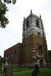 Church of Saint Peter |
| Church of St Peter and St Paul | Stallingborough, North East Lincolnshire | Parish Church | 1779-81 | 4 January 1967 | TA1950611837 53°35′22″N 0°11′46″W |
1346978 |  Church of St Peter and St Paul |
| Former Heavy Anti-aircraft Gun Site | Stallingborough, North East Lincolnshire | Heavy Anti Aircraft Battery | 1944 | 23 May 2012 | TA1841511627 53°35′16″N 0°12′45″W |
1403222 |  |
| Church of All Saints | Waltham, North East Lincolnshire | Parish Church | Late C13-Early 14th century | 4 January 1967 | TA2615103910 53°31′00″N 0°05′56″W |
1161283 |  Church of All Saints |
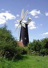
| Waltham Windmill | Waltham, North East Lincolnshire | Windmill | 1880 | 28 April 1952 | TA2595103280 53°30′40″N 0°06′08″W |
1161256 | |
| Clee Hall Farmhouse | Old Clee, North East Lincolnshire | House | Late 17th century | 6 June 1951 | TA2909308307 53°33′20″N 0°03′10″W |
1379411 | |
| Grimsby Haven Lock and Dock Wall 58 Metres Long Adjoining to West | The Docks, North East Lincolnshire | Canal Basin | 1798-1799 | 30 June 1999 | TA2721610587 53°34′35″N 0°04′48″W |
1379856 | |
| Hydraulic Accumulator Tower to West of the Dock Tower | The Docks, North East Lincolnshire | Hydraulic Accumulator Tower | 1892 | 31 October 1974 | TA2779211379 53°35′00″N 0°04′16″W |
1379871 | |
| The Grimsby Ice Factory including railings | The Docks, North East Lincolnshire | Factory | 1900-1901 | 12 September 1990 | TA2779910694 53°34′38″N 0°04′17″W |
1379842 |  The Grimsby Ice Factory including railings |
Notes
- The date given is the date used by Historic England as significant for the initial building or that of an important part in the structure's description.
- Sometimes known as OSGB36, the grid reference is based on the British national grid reference system used by the Ordnance Survey.
- The "List Entry Number" is a unique number assigned to each listed building and scheduled monument by Historic England.
External links
![]()
This article is issued from Wikipedia. The text is licensed under Creative Commons - Attribution - Sharealike. Additional terms may apply for the media files.