Grade II* listed buildings in Kirklees
There are over 20,000 Grade II* listed buildings in England. This page is a list of these buildings in the metropolitan borough of Kirklees in West Yorkshire.
List
| Name | Location | Type | Completed [note 1] | Date designated | Grid ref.[note 2] Geo-coordinates |
Entry number [note 3] | Image |
|---|---|---|---|---|---|---|---|
| Cruck Barn Adjoining and to North of Nether End Farmhouse | Nether End, Denby Dale, Kirklees | Cruck Barn | 16th century or Early 17th century | 15 August 1985 | SE2465107863 53°34′00″N 1°37′45″W |
1135327 |  |
| Thorncliffe Grange Farmhouse | Emley, Denby Dale, Kirklees | House | Soon after 1623 | 29 March 1965 | SE2500613441 53°37′01″N 1°37′24″W |
1299857 | |
| Wheatley Hill Farmhouse | Denby Dale, Denby Dale, Kirklees | Farmhouse | 16th century | 29 March 1965 | SE2526009795 53°35′03″N 1°37′12″W |
1299789 | |
| 33, 35, 37, 39 Totties Lane | Totties, Holme Valley, Kirklees | House | later alterations | 4 August 1983 | SE1571708227 53°34′14″N 1°45′51″W |
1228692 |  33, 35, 37, 39 Totties Lane |
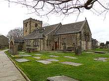
| Church of St John Baptist | Kirkheaton, Kirkburton, Kirklees | Tower | Perpendicular | 23 June 1965 | SE1788517222 53°39′04″N 1°43′51″W |
1135391 | 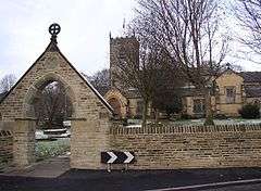 Church of St John Baptist |
| Old Milestone | Farnley Moor End, Kirkburton, Kirklees | Sundial | 1738 | 23 June 1965 | SE1662711497 53°35′59″N 1°45′01″W |
1135350 | |
| Shelley Hall | Shelley, Kirkburton, Kirklees | House | Post 1699 | 23 June 1965 | SE2073411210 53°35′49″N 1°41′17″W |
1313319 | |
| Healey House | Meltham, Kirklees | House | Late 18th century | 6 April 1967 | SE1061710751 53°35′36″N 1°50′28″W |
1183868 | |
| Church of St Mary | Mirfield, Kirklees | Church | 1871 | 14 March 1966 | SE2114820413 53°40′47″N 1°40′53″W |
1134677 | 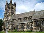 Church of St Mary |
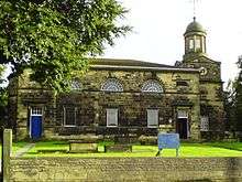
| Hopton Congregational Church | Mirfield, Kirklees | School | 1829 | 30 April 1982 | SE2011319227 53°40′09″N 1°41′49″W |
1134675 | _-_geograph.org.uk_-_132872.jpg) Hopton Congregational Church |
| The Old Rectory | Mirfield, Kirklees | House | Early 16th century | 14 March 1966 | SE2098320253 53°40′42″N 1°41′02″W |
1300318 |  The Old Rectory |
| Arts Centre Including Dwarf Wall Enclosing Queens Square | Kirklees | Gate Pier | 1819 | 11 June 1975 | SE1464816538 53°38′43″N 1°46′48″W |
1231218 |  Arts Centre Including Dwarf Wall Enclosing Queens Square |
| Bagshaw Museum, the Woodlands | Wilton Park, Kirklees | House | 1875 | 13 May 1998 | SE2349425778 53°43′40″N 1°38′43″W |
1119738 | 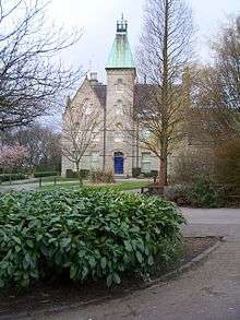 Bagshaw Museum, the Woodlands |
| Banqueting House in Grounds of Batley Hall | Upper Batley, Kirklees | Banqueting House | 17th century | 13 January 1984 | SE2431325437 53°43′29″N 1°37′59″W |
1313718 | |
| Boiler House and Engine House and Rope Race and Water Tower and Powerhouse at Westwood Mills | Linthwaite, Kirklees | Boiler House | 1826 | 20 June 2000 | SE0950214572 53°37′39″N 1°51′28″W |
1271263 | |
| Britannia Buildings | Kirklees | Commercial Office | 1856 | 29 September 1978 | SE1443116847 53°38′53″N 1°46′59″W |
1232119 |  Britannia Buildings |
| 18th century Guide Stoop (signpost) at Junction of Crosland Road and Lindley Moor Road | Kirklees | Milestone | POST MEDIEVAL | 9 August 2011 | SE1072518979 53°40′02″N 1°50′21″W |
1403442 |  18th century Guide Stoop (signpost) at Junction of Crosland Road and Lindley Moor Road |
| Canal Warehouse at Aspley Basin | Kirklees | Winch | 1774-80 | 12 September 1973 | SE1493516457 53°38′40″N 1°46′32″W |
1223867 |  Canal Warehouse at Aspley Basin |
| Church of All Saints | Dewsbury, Kirklees | Dwelling | Anglo Saxon | 30 June 1949 | SE2459021524 53°41′23″N 1°37′45″W |
1134712 | |
| Church of St John | Bay Hall, Kirklees | Church | 1851 | 3 March 1952 | SE1410217729 53°39′21″N 1°47′17″W |
1217625 |  Church of St John |
| Church of St Matthew | Rastrick, Kirklees | Church | 1875 | 3 January 1967 | SE1385421578 53°41′26″N 1°47′30″W |
1183810 | |
| Church of St Peter | Hartshead, Kirklees | Church | Norman | 12 January 1967 | SE1790023310 53°42′21″N 1°43′49″W |
1134588 | |
| Church of St Peter | Birstall, Kirklees | Church | c. 1100 | 29 March 1963 | SE2185526179 53°43′54″N 1°40′13″W |
1134648 |  Church of St Peter |
| Church of St Thomas | Huddersfield, Kirklees | Church | 1857-59 | 3 May 1952 | SE1382916225 53°38′32″N 1°47′32″W |
1134950 |  Church of St Thomas |
| Church of the Holy Trinity | Highfield, Kirklees | Parish Church | 1816-19 | 29 September 1978 | SE1378117062 53°39′00″N 1°47′35″W |
1223128 |  Church of the Holy Trinity |
| Close Gate Bridge | Marsden, Kirklees | Packhorse Bridge | 17th century or 18th century | 25 May 1966 | SE0287412100 53°36′20″N 1°57′29″W |
1276561 | 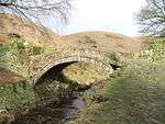 Close Gate Bridge |
| Crosland Hall | Crosland Moor, Kirklees | House | Early 17th century | 3 March 1952 | SE1104714310 53°37′31″N 1°50′04″W |
1134305 |  Crosland Hall |
| Dod Lea House | Longwood, Kirklees | House | 1674 | 29 September 1978 | SE1045117129 53°39′02″N 1°50′36″W |
1313538 |  Dod Lea House |
| Entrance Portal to Standedge Canal Tunnel | Marsden, Kirklees | Canal Tunnel | 1797-1811 | 11 July 1985 | SE0395911911 53°36′13″N 1°56′30″W |
1266901 |  Entrance Portal to Standedge Canal Tunnel |
| Fenny Hall | Almondbury, Kirklees | House | 17th century or Early 18th century | 3 March 1952 | SE1774015206 53°37′59″N 1°44′00″W |
1134260 | |
| Highfield Farmhouse and Cottage | Birstall, Kirklees | Farmhouse | 17th century | 15 May 1980 | SE2228326687 53°44′10″N 1°39′49″W |
1184038 | |
| Huddersfield Technical College (administration and Business) | Highfield, Kirklees | Steps | 1831 | 29 September 1978 | SE1407916836 53°38′52″N 1°47′19″W |
1228645 |  Huddersfield Technical College (administration and Business) |
| Lindley Clock Tower | Lindley, Kirklees | Steps | 1900-2 | 12 September 1973 | SE1188018051 53°39′32″N 1°49′18″W |
1215049 |  Lindley Clock Tower |
| Linthwaite Hall | Slaithwaite, Kirklees | Apartment | c. 1600 | 25 May 1966 | SE0849013878 53°37′17″N 1°52′23″W |
1216775 |  Linthwaite Hall |
| Lion Buildings | Kirklees | Statue | Modern | 29 September 1978 | SE1447316884 53°38′54″N 1°46′57″W |
1134167 |  Lion Buildings |
| Longley Old Hall | Kirklees | House | Medieval | 3 March 1952 | SE1542415015 53°37′53″N 1°46′06″W |
1288214 |  Longley Old Hall |
| Manor House | Slaithwaite, Kirklees | Manor House | Late 16th century | 25 May 1966 | SE0777513991 53°37′21″N 1°53′02″W |
1233457 |  Manor House |
| Manor House Peel House | Gomersal, Kirklees | Manor House | Mid-late 17th century | 12 January 1967 | SE2068426758 53°44′12″N 1°41′16″W |
1184378 | |
| Mellor Bridge | Marsden, Kirklees | Packhorse Bridge | 17th century or 18th century | 25 May 1966 | SE0470211679 53°36′06″N 1°55′50″W |
1275335 | 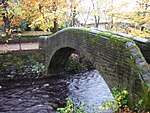 Mellor Bridge |
| Mile Pole Adjacent to Lower Royal George Public House | Pole Moor, Kirklees | Signpost | 1755 | 11 July 1985 | SE0696916307 53°38′36″N 1°53′46″W |
1221381 |  Mile Pole Adjacent to Lower Royal George Public House |
| Mill Dam at Westwood Mills | Linthwaite, Kirklees | Wall | 1801 | 20 June 2000 | SE0948214557 53°37′39″N 1°51′29″W |
1271264 | |
| Milnsbridge House | Milnsbridge, Kirklees | House | Early 18th century | 3 March 1952 | SE1166616033 53°38′26″N 1°49′30″W |
1290158 |  Milnsbridge House |
| New House Hall | Sheepridge, Kirklees | House | 1581-1638 | 3 March 1952 | SE1551119754 53°40′27″N 1°46′00″W |
1279156 | |
| North Range at Westwood Mills | Linthwaite, Kirklees | Electricity Sub Station | C20 | 11 July 1985 | SE0949914607 53°37′40″N 1°51′28″W |
1216965 | |
| Offices and Workshop Range at Westwood Mills | Linthwaite, Kirklees | Electricity Sub Station | C20 | 11 July 1985 | SE0950914593 53°37′40″N 1°51′28″W |
1217132 | |
| Old Hall | Birstall, Kirklees | Detached House | 1700 | 29 March 1963 | SE2239026443 53°44′02″N 1°39′43″W |
1300342 | |
| Old Hall Farmhouse | Roberttown, Kirklees | Farmhouse | 17th century | 12 January 1967 | SE1985222984 53°42′10″N 1°42′03″W |
1135409 |  Old Hall Farmhouse |
| Old Hall Public House | Heckmondwike, Kirklees | House | 17th century | 11 June 1980 | SE2140623931 53°42′41″N 1°40′38″W |
1300236 |  Old Hall Public House |
| Parish Church of St Peter | Kirklees | Parish Church | 1834-36 | 3 March 1952 | SE1457816771 53°38′50″N 1°46′51″W |
1134977 |  Parish Church of St Peter |
| Pollard Hall | Gomersal, Kirklees | House | 1659 | 12 January 1967 | SE2082226154 53°43′53″N 1°41′09″W |
1313297 | |
| Principal Mill Building at Folly Hall Mill | Kirklees | Textile Mill | Early 19th century | 29 September 1978 | SE1418015990 53°38′25″N 1°47′13″W |
1134242 |  Principal Mill Building at Folly Hall Mill |
| Providence Place United Reformed Church, Gate Piers and Gates | Cleckheaton, Kirklees | Gate | 1857-9 | 30 April 1982 | SE1907925707 53°43′39″N 1°42′44″W |
1184234 | 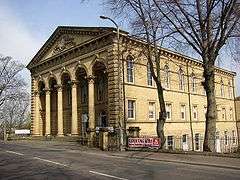 Providence Place United Reformed Church, Gate Piers and Gates |
| Red House | Kirklees | House | 1660 | 12 January 1967 | SE2078526259 53°43′56″N 1°41′11″W |
1135404 | |
| Rose Hill | Kirklees | House | Late 19th century | 29 September 1978 | SE1310518098 53°39′33″N 1°48′11″W |
1134389 |  Rose Hill |
| The George Hotel | Kirklees | Hotel | 1849-50 | 20 September 1977 | SE1441816956 53°38′56″N 1°47′00″W |
1277386 |  The George Hotel |
| The Second Hall (to South West of Lees Hall) | Thornhill Lees, Kirklees | House | 17th century | 30 June 1949 | SE2329619984 53°40′33″N 1°38′56″W |
1134698 | |
| Thorpe Farm Barn | Almondbury, Kirklees | Barn | 19th century | 3 March 1952 | SE1748215463 53°38′07″N 1°44′14″W |
1313840 | |
| Upper Independent Chapel | Heckmondwike, Kirklees | Congregational Chapel | 1890 | 7 June 1978 | SE2224323716 53°42′34″N 1°39′52″W |
1134623 |  Upper Independent Chapel |
| Walton Cross 100 Yards North of Walton Cross Farmhouse | Hartshead, Kirklees | Cross | 11th century | 12 January 1967 | SE1761423792 53°42′37″N 1°44′05″W |
1313305 |  Walton Cross 100 Yards North of Walton Cross Farmhouse |
| West Block at Westwood Mills | Linthwaite, Kirklees | Carding Mill | c. 1800 | 11 July 1985 | SE0948914590 53°37′40″N 1°51′29″W |
1216966 | |
| Wood End Farm | Slaithwaite, Kirklees | Farmhouse | 1626 | 11 July 1985 | SE0813814914 53°37′50″N 1°52′42″W |
1233729 |  Wood End Farm |
| Wormalls Hall | Almondbury, Kirklees | House | 16th century | 3 March 1952 | SE1685315006 53°37′53″N 1°44′48″W |
1224854 | 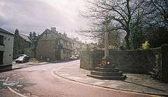 Wormalls Hall |
| 12–20 St Georges Square | Kirklees | House | Mid 19th century | 11 February 1977 | SE1432316790 53°38′51″N 1°47′05″W |
1232139 | |
| 7 St Georges Square | Kirklees | House | Mid 19th century | 29 September 1978 | SE1438716843 53°38′52″N 1°47′02″W |
1231781 |  7 St Georges Square |
| 42–46 Townend | Almondbury, Kirklees | House | 17th century | 29 September 1978 | SE1654715524 53°38′10″N 1°45′04″W |
1239763 | |
| 2–6 Railway Street | Kirklees | House | Mid 19th century | 11 February 1977 | SE1434616762 53°38′50″N 1°47′04″W |
1278114 |  2–6 Railway Street |
| 8 and 10 Railway Street | Kirklees | House | Mid 19th century | 11 February 1977 | SE1434316790 53°38′51″N 1°47′04″W |
1231473 |  8 and 10 Railway Street |
| 59 Quarmby Fold | Kirklees | House | 16th century | 3 March 1952 | SE1141117258 53°39′06″N 1°49′44″W |
1230100 |  59 Quarmby Fold |
| 47 and 49 Quarmby Fold | Kirklees | House | 16th century | 3 March 1952 | SE1140117255 53°39′06″N 1°49′44″W |
1278771 |  47 and 49 Quarmby Fold |

Notes
- The date given is the date used by Historic England as significant for the initial building or that of an important part in the structure's description.
- Sometimes known as OSGB36, the grid reference is based on the British national grid reference system used by the Ordnance Survey.
- The "List Entry Number" is a unique number assigned to each listed building and scheduled monument by Historic England.
External links
![]()
This article is issued from Wikipedia. The text is licensed under Creative Commons - Attribution - Sharealike. Additional terms may apply for the media files.