Grade II* listed buildings in Kettering (borough)
There are over 20,000 Grade II* listed buildings in England. This page is a list of these buildings in the district of Kettering in Northamptonshire.
Kettering
| Name | Location | Type | Completed [note 1] | Date designated | Grid ref.[note 2] Geo-coordinates |
Entry number [note 3] | Image |
|---|---|---|---|---|---|---|---|
| The Rectory | Barton Seagrave, Kettering | House | Late 17th century | 27 February 1950 | SP8876377048 52°23′03″N 0°41′50″W |
1372630 |  |
| Church of All Saints | Braybrooke, Kettering | Parish Church | 13th century | 25 February 1957 | SP7646684592 52°27′14″N 0°52′34″W |
1289123 |  Church of All Saints |
| Church of St Andrew | Broughton, Kettering | Parish Church | 12th century | 25 February 1957 | SP8371875799 52°22′26″N 0°46′18″W |
1289054 | .jpg) Church of St Andrew |
| Dovecote at Burton Latimer Hall | Burton Latimer, Kettering | Dovecote | late 16th century or early 17th century | 18 January 1950 | SP8985275342 52°22′08″N 0°40′54″W |
1191366 | |
| Jacobean House | Burton Latimer, Kettering | House | 1972 | 18 January 1950 | SP9023275083 52°21′59″N 0°40′34″W |
1052126 | .jpg) Jacobean House |
| Church of St Andrew | Cranford St Andrew, Cranford, Kettering | Church | Late 12th century | 25 February 1957 | SP9238677271 52°23′08″N 0°38′38″W |
1052098 | |
| Church of St John | Cranford St John, Cranford, Kettering | Parish Church | 12th century | 25 February 1957 | SP9272677092 52°23′02″N 0°38′21″W |
1191477 |  Church of St John |
| Dovecote at Dairy Farm | Cranford St Andrew, Cranford, Kettering | Dovecote | 15th century | 25 October 1951 | SP9231177298 52°23′09″N 0°38′42″W |
1191580 | .jpg) Dovecote at Dairy Farm |
| The Manor House | Cranford St John, Cranford, Kettering | House | 19th century | 25 October 1951 | SP9250376960 52°22′58″N 0°38′32″W |
1052100 | |
| Cransley Hall | Cransley, Kettering | Country House | 1677 | 25 October 1951 | SP8288876605 52°22′52″N 0°47′01″W |
1289058 | |
| Church of All Saints | Dingley, Kettering | Church | 13th century | 25 February 1957 | SP7695787696 52°28′54″N 0°52′06″W |
1372349 | .jpg) Church of All Saints |
| Bridge over River Ise | Geddington, Kettering | Bridge | c. 1250 | 25 February 1957 | SP8938682923 52°26′13″N 0°41′12″W |
1191813 |  Bridge over River Ise |
| Church of St Peter and Paul | Harrington, Kettering | Parish Church | Early 14th century | 25 February 1957 | SP7783880574 52°25′03″N 0°51′25″W |
1213602 | |
| Church of St Leonard | Loddington, Kettering | Parish Church | 13th century | 25 February 1957 | SP8146278355 52°23′50″N 0°48′15″W |
1288918 |  Church of St Leonard |
| Loddington Hall | Loddington, Kettering | Apartment | c. 1300 | 25 October 1951 | SP8138578433 52°23′52″N 0°48′19″W |
1213737 | |
| Church of St Peter | Little Oakley, Newton and Little Oakley, Kettering | Parish Church | 13th century | 25 February 1957 | SP8919785596 52°27′40″N 0°41′19″W |
1052023 |  Church of St Peter |
| Manor Farmhouse and attached Outbuildings | Little Oakley, Newton and Little Oakley, Kettering | Farmhouse | 16th century | 25 October 1951 | SP8917085561 52°27′39″N 0°41′20″W |
1372407 | |
| Newton Field Centre | Newton, Newton and Little Oakley, Kettering | Parish Church | 14th century | 25 February 1957 | SP8844883287 52°26′25″N 0°42′01″W |
1052061 | 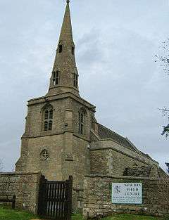 Newton Field Centre |
| The Orton Trust Workshop | Orton, Kettering | Stonemasons Yard | 1991 | 25 October 1951 | SP8056679417 52°24′25″N 0°49′02″W |
1213823 |  The Orton Trust Workshop |
| Jesus Hospital | Rothwell, Kettering | Apartment | 1950 | 12 June 1950 | SP8167681092 52°25′18″N 0°48′01″W |
1288810 |  Jesus Hospital |
| Rothwell United Reformed Church | Rothwell, Kettering | Church Hall | 1909 | 23 January 1985 | SP8137480930 52°25′13″N 0°48′18″W |
1213989 | .jpg) Rothwell United Reformed Church |
| Church of All Saints | Rushton, Kettering | Parish Church | Norman | 25 February 1957 | 49°46′01″N 7°33′26″W | 1052039 |  Church of All Saints |
| Glendon Hall | Glendon, Rushton, Kettering | House | mid/late 16th century | 25 October 1951 | SP8447481356 52°25′25″N 0°45′33″W |
1192189 | .jpg) Glendon Hall |
| The Grooms House | Rushton, Kettering | House | Early 18th century | 25 October 1951 | SP8385382795 52°26′12″N 0°46′05″W |
1372412 | |
| Church of St Botolph | Stoke Albany, Kettering | Church | Late 13th century | 25 February 1957 | SP8055188294 52°29′12″N 0°48′55″W |
1372373 | .jpg) Church of St Botolph |
| The Manor House | Stoke Albany, Kettering | Manor House | 15th century TO 17th century | 25 October 1951 | SP8069287914 52°28′59″N 0°48′48″W |
1189756 | |
| The Old House | Stoke Albany, Kettering | Manor House | Late 14th century | 25 October 1951 | SP8049488256 52°29′11″N 0°48′58″W |
1052146 | |
| Church of All Saints | Thorpe Malsor, Kettering | Parish Church | Late 13th century | 25 February 1957 | SP8336979008 52°24′10″N 0°46′34″W |
1214178 | |
| Montagu Hospital | Weekley, Kettering | House | 1611 | 25 October 1951 | SP8880280918 52°25′09″N 0°41′44″W |
1052010 | .jpg) Montagu Hospital |
| The Dower House | Boughton Park, Weekley, Kettering | House | 1705 | 25 October 1951 | SP9004681543 52°25′28″N 0°40′38″W |
1342871 | |
| Church of All Saints | Wilbarston, Kettering | Church | 12th century | 25 February 1957 | SP8119988364 52°29′14″N 0°48′20″W |
1293981 | .jpg) Church of All Saints |
| Barton Seagrave Hall | Barton Seagrave, Kettering | Country House | 18th century | 27 February 1950 | SP8874877304 52°23′12″N 0°41′51″W |
1372597 | |
| Carey House | Kettering | House | 18th century | 27 February 1950 | SP8653878904 52°24′05″N 0°43′46″W |
1051659 | .jpg) Carey House |
| Church of Saint Mary | Kettering | Church | 1932 | 14 April 1976 | SP8743179037 52°24′09″N 0°42′59″W |
1051645 |  Church of Saint Mary |
| Manor House | Kettering | House | 17th century | 27 February 1950 | SP8672478376 52°23′48″N 0°43′37″W |
1189094 | |
| Sawyer's Almshouses | Kettering | Almshouse | 1688 | 27 February 1950 | SP8663978269 52°23′44″N 0°43′41″W |
1372594 | |


Notes
- The date given is the date used by Historic England as significant for the initial building or that of an important part in the structure's description.
- Sometimes known as OSGB36, the grid reference is based on the British national grid reference system used by the Ordnance Survey.
- The "List Entry Number" is a unique number assigned to each listed building and scheduled monument by Historic England.
External links
![]()
This article is issued from Wikipedia. The text is licensed under Creative Commons - Attribution - Sharealike. Additional terms may apply for the media files.