Grade II* listed buildings in Ipswich
There are over 20,000 Grade II* listed buildings in England. This page is a list of these buildings in the district of Ipswich in Suffolk.
Ipswich
| Name | Location | Type | Completed [note 1] | Date designated | Grid ref.[note 2] Geo-coordinates |
Entry number [note 3] | Image |
|---|---|---|---|---|---|---|---|
| Church of St Clement | Ipswich | Church | 15th century | 19 December 1951 | TM1687344222 52°03′14″N 1°09′42″E |
1374812 | |
| Church of St Lawrence | Ipswich | Church | 15th century | 19 December 1951 | TM1639144586 52°03′27″N 1°09′18″E |
1206619 | |
| Church of St Mary at the Elms | Ipswich | Church | Late 11th century or early 12th century | 19 December 1951 | TM1606044541 52°03′26″N 1°09′00″E |
1037764 | |
| Church of St Mary at the Quay | Ipswich | Youth Club | 15th century (after 1448) | 19 December 1951 | TM1651444095 52°03′11″N 1°09′23″E |
1037707 | |
| Church of St Mary Le Tower | Ipswich | Church | Medieval | 19 December 1951 | TM1641544695 52°03′30″N 1°09′19″E |
1235800 | |
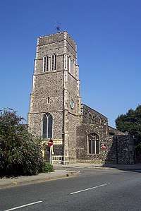
| Church of St Matthew | Ipswich | Church | 12th century | 19 December 1951 | TM1581444723 52°03′32″N 1°08′48″E |
1037690 |  Church of St Matthew |
| Church of St Nicholas | Ipswich | Church | c. 1300 | 19 December 1951 | TM1617344284 52°03′17″N 1°09′06″E |
1187192 |  Church of St Nicholas |
| Church of St Peter | Ipswich | Church | 14th century | 19 December 1951 | TM1635844118 52°03′11″N 1°09′15″E |
1037757 | |
| Church of St Stephen | Ipswich | Church | 15th century | 19 December 1951 | TM1639844492 52°03′24″N 1°09′18″E |
1235373 |  Church of St Stephen |
| Cobbolds on the Quay Public House (Isaacs) | Ipswich | Malt Kiln | Earlier origins | 19 December 1951 | TM1681644096 52°03′10″N 1°09′39″E |
1374793 | 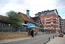 Cobbolds on the Quay Public House (Isaacs) |
| Gippeswyk Hall | Ipswich | House | c. 1600 | 19 December 1951 | TM1525843731 52°03′01″N 1°08′17″E |
1037740 |  Gippeswyk Hall |
| Great White Horse Hotel | Ipswich | Courtyard | Early 19th century | 19 December 1951 | TM1646244644 52°03′28″N 1°09′22″E |
1235799 | .jpg) Great White Horse Hotel |
| 24 St Margaret's Plain | Ipswich | Shop (Blake Mayhew) | C20 | 19 December 1951 | TM1654344794 52°03′33″N 1°09′26″E |
1235595 |  24 St Margaret's Plain |
| 35, St Margaret's Street | Ipswich | Shop | Post 17th century | 19 December 1951 | TM1664044707 52°03′30″N 1°09′31″E |
1235206 |  35, St Margaret's Street |
| 37 & 39, St Margaret's St (Olde Tudor Cafe) | Ipswich | Shop | C18/C19 | 19 December 1951 | TM1663044712 52°03′30″N 1°09′31″E |
1235297 |  37 & 39, St Margaret's St (Olde Tudor Cafe) |
| 56 & 58, St Margaret's St (Blake Mayhew) | Ipswich | Office | C20 | 4 August 1972 | TM1654444791 52°03′33″N 1°09′26″E |
1235293 |  56 & 58, St Margaret's St (Blake Mayhew) |
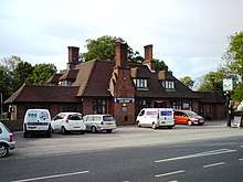
| The Margaret Catchpole Public House | Ipswich | Public House | 1936 | 13 December 1995 | TM1762143280 52°02′43″N 1°10′19″E |
1243454 | |
| The Old Custom House | Ipswich | Custom House | 1844 | 19 December 1951 | TM1668344092 52°03′10″N 1°09′32″E |
1374818 | .jpg) The Old Custom House |
| Warehouse Attached to West of Warehouse (the Crossway) at Rear of Numbers 80 and 80a Fore Street | Ipswich | Warehouse | 17th century or earlier | 19 December 1951 | TM1680844120 52°03′11″N 1°09′39″E |
1096034 |  |
| Woodside | Ipswich | House | 1872 | 15 December 1977 | TM1594845790 52°04′06″N 1°08′57″E |
1264602 | |
| Curson Lodge (45 and 45a St Nicholas Street) | Ipswich | House | 18th century | 4 August 1972 | TM1626144305 52°03′18″N 1°09′10″E |
1235464 |  Curson Lodge (45 and 45a St Nicholas Street) |
| Curson Lodge (1 Silent Street, also 47 Nicholas Street) | Ipswich | Cross Wing House | 15th century | 19 December 1951 | TM1626344303 52°03′18″N 1°09′11″E |
1265084 | Curson Lodge (1 Silent Street, also 47 Nicholas Street) |
| Curson Lodge (3–9 Silent Street) | Ipswich | Timber Framed Building | 16th century | 19 December 1951 | TM1626644306 52°03′18″N 1°09′11″E |
1235576 |  Curson Lodge (3–9 Silent Street) |
| 19 Tower Street | Ipswich | House | 18th century | 19 December 1951 | TM1639744748 52°03′32″N 1°09′19″E |
1235803 | |
| 24 Fore Street | Ipswich | House | 18th century | 19 December 1951 | TM1669244266 52°03′16″N 1°09′33″E |
1374792 |  24 Fore Street |
| 54–58 Fore Street | Ipswich | House/Shops (Steve Tattooist) | Pre Early 19th century | 20 March 1975 | TM1677144185 52°03′13″N 1°09′37″E |
1236157 |  54–58 Fore Street |
| Neptune Inn, Ipswich, 86 Fore Street | Ipswich | House | 1639 | 19 December 1951 | TM1685544132 52°03′11″N 1°09′41″E |
1355165 |  Neptune Inn, Ipswich, 86 Fore Street |
| 88 Fore Street | Ipswich | Courtyard | C15-C16 | 19 December 1951 | TM1686144129 52°03′11″N 1°09′42″E |
1374794 |  88 Fore Street |


Notes
- The date given is the date used by Historic England as significant for the initial building or that of an important part in the structure's description.
- Sometimes known as OSGB36, the grid reference is based on the British national grid reference system used by the Ordnance Survey.
- The "List Entry Number" is a unique number assigned to each listed building and scheduled monument by Historic England.
External links
![]()
This article is issued from Wikipedia. The text is licensed under Creative Commons - Attribution - Sharealike. Additional terms may apply for the media files.