Grade II* listed buildings in Charnwood (borough)
There are over 20,000 Grade II* listed buildings in England. This page is a list of these buildings in Charnwood.
Charnwood
| Name | Location | Type | Completed [note 1] | Date designated | Grid ref.[note 2] Geo-coordinates |
Entry number [note 3] | Image |
|---|---|---|---|---|---|---|---|
| Pack Horse Bridge | The Leys, Anstey, Charnwood | Packhorse Bridge | C16/C17 | 1 June 1966 | SK5518508448 52°40′15″N 1°11′07″W |
1177116 |  Pack Horse Bridge |
| Barkby Grange Farmhouse | Barkby, Charnwood | Farmhouse | 1855 | 30 November 1977 | SK6467909275 52°40′38″N 1°02′41″W |
1074495 |  |
| Church of the Holy Trinity | Barrow upon Soar, Charnwood | Parish Church | Medieval | 1 June 1966 | SK5764617577 52°45′10″N 1°08′50″W |
1074589 |  Church of the Holy Trinity |
| Church of All Saints | Beeby, Charnwood | Parish Church | Late 13th century | 1 June 1966 | SK6640708321 52°40′07″N 1°01′10″W |
1177337 |  Church of All Saints |
| Church of All Saints | Cossington, Charnwood | Church | 13th century | 1 June 1966 | SK6036413664 52°43′02″N 1°06′28″W |
1228032 |  Church of All Saints |
| The Old Rectory | Cossington, Charnwood | House | 16th century | 2 July 1951 | SK6034413621 52°43′01″N 1°06′29″W |
1228038 | |
| Church of St Peter and St Paul | Hathern, Charnwood | Church | 14th century | 15 March 1965 | SK5027022428 52°47′49″N 1°15′21″W |
1320287 |  Church of St Peter and St Paul |
| The Village Cross | Hathern, Charnwood | Village Cross | Medieval | 15 March 1965 | SK5028822343 52°47′47″N 1°15′20″W |
1361141 |  The Village Cross |
| Church of St Peter | Mountsorrel, Charnwood | Church | 14th century | 1 June 1966 | SK5811615106 52°43′50″N 1°08′27″W |
1228111 |  Church of St Peter |
| The Market Cross | Mountsorrel, Charnwood | Market Cross | 1793 | 1 June 1966 | SK5817915051 52°43′48″N 1°08′24″W |
1287313 |  The Market Cross |
| 2, Loughborough Road | Mountsorrel, Charnwood | House | 1788 | 12 October 1984 | SK5813015131 52°43′51″N 1°08′26″W |
1228109 | |
| Bradgate House and chapel | Bradgate Park, Newtown Linford, Charnwood | Country House | Begun c1490 | 1 June 1966 | SK5342610174 52°41′12″N 1°12′40″W |
1074677 |  Bradgate House and chapel |
| Church of All Saints | Newtown Linford, Charnwood | Church | C14/15 | 1 June 1966 | SK5220709782 52°41′00″N 1°13′45″W |
1074679 | 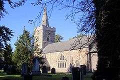 Church of All Saints |
| Garden Wall | Bradgate Park, Newtown Linford, Charnwood | Garden Wall | Early 16th century | 1 June 1966 | SK5349210161 52°41′11″N 1°12′36″W |
1361080 | |
| Church of St Andrew | Prestwold Hall, Prestwold, Charnwood | Parish Church | Late 14th century | 1 June 1966 | SK5778221444 52°47′15″N 1°08′41″W |
1074561 |  Church of St Andrew |
| The Old Hall | Queniborough, Charnwood | House | 1675-6 | 1 June 1966 | SK6474612395 52°42′19″N 1°02′36″W |
1074513 | |
| Church of St Botolph | Ratcliffe on the Wreake, Charnwood | Church | 14th century | 1 June 1966 | SK6304614534 52°43′29″N 1°04′05″W |
1278781 | |
| Church of St Michael and All Saints | Rearsby, Charnwood | Parish Church | Late 13th century to early 14th century | 1 June 1966 | SK6511114638 52°43′32″N 1°02′14″W |
1307375 |  Church of St Michael and All Saints |
| Old Hall | Rearsby, Charnwood | House | Late 19th century | 1 June 1966 | SK6500814299 52°43′21″N 1°02′20″W |
1361185 |  Old Hall |
| Church of St Mary the Virgin and St John the Baptist | Rothley, Charnwood | Church | 13th century | 1 June 1966 | SK5859512654 52°42′30″N 1°08′03″W |
1230285 |  Church of St Mary the Virgin and St John the Baptist |
| Church of All Saints | Seagrave, Charnwood | Church | 13th century | 1 June 1966 | SK6199217586 52°45′08″N 1°04′59″W |
1230528 |  Church of All Saints |
| Church of St Mary | Sileby, Charnwood | Church | 13th century | 1 June 1966 | SK6005115174 52°43′51″N 1°06′44″W |
1230687 | |
| Church of St John the Baptist | South Croxton, Charnwood | Parish Church | 14th century | 1 June 1966 | SK6917710328 52°41′10″N 0°58′41″W |
1361188 |  Church of St John the Baptist |
| Church of St Leonard | Swithland, Charnwood | Church | 13th century and Later | 1 June 1966 | SK5549412826 52°42′37″N 1°10′48″W |
1177875 |  Church of St Leonard |
| Danvers Tomb at Church of St Leonard | Swithland, Charnwood | Table Tomb | 1745 | 1 June 1966 | SK5552312834 52°42′37″N 1°10′47″W |
1361113 | |
| Church of Holy Trinity | Thrussington, Charnwood | Church | 13th century | 1 June 1966 | SK6503615779 52°44′09″N 1°02′18″W |
1230701 |  Church of Holy Trinity |
| Church of All Saints | Thurcaston and Cropston, Charnwood | Church | 12th century | 1 June 1966 | SK5653610680 52°41′27″N 1°09′54″W |
1074627 |  Church of All Saints |
| Latimer's House | Thurcaston and Cropston, Charnwood | House | C15/C16 | 9 July 1951 | SK5666510851 52°41′33″N 1°09′47″W |
1074625 | |
| Church of St Michael | Thurmaston, Charnwood | Parish Church | c. 1300 | 1 June 1966 | SK6103109359 52°40′43″N 1°05′55″W |
1307276 |  Church of St Michael |
| Stoneywell Cottage | Ulverscroft, Charnwood | House | 1899 | 1 June 1966 | SK4978711788 52°42′05″N 1°15′53″W |
1361102 | |
| Beaumanor Hall | Woodhouse, Charnwood | House | 13th century | 21 March 1972 | SK5377915685 52°44′10″N 1°12′18″W |
1361103 | |
| Church of St Mary in the Elms | Woodhouse, Charnwood | Church | 15th century | 1 June 1966 | SK5385015150 52°43′53″N 1°12′14″W |
1074611 |  Church of St Mary in the Elms |
| Church of St Paul | Woodhouse Eaves, Charnwood | Church | 1837 | 15 March 1984 | SK5316714080 52°43′18″N 1°12′51″W |
1074609 |  Church of St Paul |
| Stables, Clock Tower and Outhouses at Beaumanor Hall | Beaumanor Park, Woodhouse, Charnwood | Wall | 1842-1854 | 15 March 1984 | SK5378215798 52°44′14″N 1°12′18″W |
1074641 | |
| Terrace Walls, Urns, Fountain and Seat at Beaumanor Hall | Beaumanor Park, Woodhouse, Charnwood | Garden Wall | Mid 19th century | 15 March 1984 | SK5377115583 52°44′07″N 1°12′18″W |
1180207 | |
| Garendon Park, the Temple of Venus | Loughborough, Charnwood | Statue | 1730s | 15 March 1965 | SK4979019057 52°46′01″N 1°15′49″W |
1116109 |  Garendon Park, the Temple of Venus |
| Taylor's Bell Foundry (that Part on East Side of Cobden Street) | Loughborough, Charnwood | Bell Foundry | c. 1874 | 24 December 1985 | SK5414519810 52°46′23″N 1°11′56″W |
1236293 |  Taylor's Bell Foundry (that Part on East Side of Cobden Street) |
| Taylor's Bell Foundry (that Part on West Side of Cobden Street) | Loughborough, Charnwood | Carpenters Workshop | 1859 | 24 December 1985 | SK5414019825 52°46′24″N 1°11′56″W |
1264685 | Taylor's Bell Foundry (that Part on West Side of Cobden Street) |
| The Old Rectory | Loughborough, Charnwood | Cross Passage House | 16th century | 15 March 1965 | SK5375819984 52°46′29″N 1°12′16″W |
1320404 |  The Old Rectory |


Notes
- The date given is the date used by Historic England as significant for the initial building or that of an important part in the structure's description.
- Sometimes known as OSGB36, the grid reference is based on the British national grid reference system used by the Ordnance Survey.
- The "List Entry Number" is a unique number assigned to each listed building and scheduled monument by Historic England.
External links
![]()
This article is issued from Wikipedia. The text is licensed under Creative Commons - Attribution - Sharealike. Additional terms may apply for the media files.