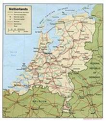
Geography of the European Netherlands
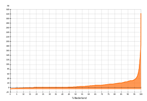
The geography of the European Netherlands is unusual in that much of its land has been reclaimed from the sea and is below sea level, protected by dikes. It is a small country with a total area of 41,545 km2 (16,041 sq mi)[1] and ranked 131st. With a population of 17.4 million[2] and density of 521/km2 (1,350/sq mi) makes it the most densely populated country in Europe (except for tiny city states like Monaco, Vatican City and San Marino), and the 12th most densely populated country in the world, behind only three countries with a population over 16 million. Consequently, the Netherlands is highly urbanized.
 | |
| Continent | Europe |
|---|---|
| Region | Western Europe |
| Coordinates | 52°22′N 4°53′E |
| Area | Ranked 131st |
| • Total | 41,545 km2 (16,041 sq mi) |
| • Land | 80.59% |
| • Water | 19.41% |
| Coastline | 451 km (280 mi) |
| Borders | Total land borders: 1,027 km2 (397 sq mi) |
| Highest point | Vaalserberg 322.7 m (1,059 ft) |
| Lowest point | Zuidplaspolder (Nieuwerkerk aan den IJssel) −7 m (−23 ft) |
| Longest river | Rhine 764 km (475 mi) |
| Largest lake | IJsselmeer 1,100 km2 (420 sq mi) |
| Exclusive economic zone | 154,011 km2 (59,464 sq mi) |
Statistics
Geographic coordinates: 52°22′N 4°53′E
The Dutch RD coordinate system (Rijksdriehoeksmeting) is also in common use; see (pdf, in Dutch; see little map on p. 1) and converter. There is a west–east coordinate between 0 and 280 km, and a south–north coordinate between 300 and 620 km.
The reference point is the Onze-Lieve-Vrouwentoren (Our Lady's Tower) in Amersfoort, with RD coordinates (155.000, 463.000) and geographic coordinates approximately 52°9′N 5°23′E.
Area:[3]
total: 41,545 km2 (16,041 sq mi)
land: 33,481 km2 (12,927 sq mi)
water: 8,064 km2 (3,114 sq mi)
Land boundaries:
total: 1,027 km (638 mi)
border countries:
Coastline: 451 km (280 mi)
Maritime claims:
territorial sea: 12 nmi (22.2 km; 13.8 mi)
contiguous zone: 24 nmi (44.4 km; 27.6 mi)
exclusive economic zone: 154,011 km2 (59,464 sq mi) with 200 nmi (370.4 km; 230.2 mi)
Climate: temperate; marine; cool summers and mild winters (European mainland), tropical (Caribbean islands)
Terrain: mostly coastal lowland and reclaimed land (polders); some hills in southeast
Elevation extremes:
lowest point: Zuidplaspolder (Nieuwerkerk aan den IJssel) −7 m (−23 ft), below sea level.
highest point on European mainland: Vaalserberg 322.7 m (1,059 ft) above sea level.
highest point (including the Caribbean islands): Mount Scenery on Saba 887 m (2,910 ft) above sea level.
Natural resources: natural gas, petroleum, peat, limestone, salt, sand and gravel, arable land
Land use: (2011)
arable land: 25.08%
permanent crops: 0.88%
other: 74.04%
Irrigated land (2007): 4,572 km2 (1,765 sq mi)
Total renewable water resources (2011): 91 km3 (22 cu mi)
Natural hazards: flooding by sea and rivers is a constant danger. The extensive system of dikes, dams, and sand dunes protect nearly one-half of the total area from being flooded during the heavy autumn storms from the north-west.
Environment – current issues: water pollution in the form of heavy metals, organic compounds, and fertilisers such as nitrates and phosphates; air pollution from vehicles and refining activities; acid rain
Environment – international agreements:
party to:
Air Pollution, Air Pollution-Nitrogen Oxides, Air Pollution-Persistent Organic Pollutants, Air Pollution-Sulphur 85, Air Pollution-Sulphur 94, Air Pollution-Volatile Organic Compounds, Antarctic-Environmental Protocol, Antarctic Treaty, Biodiversity, Climate Change, Climate Change-Kyoto Protocol, Desertification, Endangered Species, Environmental Modification, Hazardous Wastes, Law of the Sea, Marine Dumping, Marine Life Conservation, Ozone Layer Protection, Ship Pollution, Tropical Timber 83, Tropical Timber 94, Wetlands, Whaling
signed, but not ratified:
none
Landscape
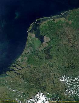
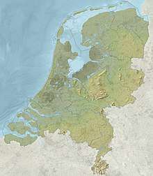
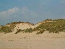
The country can be split into two areas: the low and flat lands in the west and north, and the higher lands with minor hills in the east and south. The former, including the reclaimed polders and river deltas, make up about half of its surface area and are less than 1 metre (3.3 ft) above sea level, much of it actually below sea level. An extensive range of seawalls and coastal dunes protect the Netherlands from the sea, and levees and dikes along the rivers protect against river flooding. The rest of the country is mostly flat; only in the extreme south of the country does the land rise to any significant extent, in the foothills of the Ardennes mountains. This is where Vaalserberg is located, the highest point on the European part of the Netherlands at 322.7 metres (1,059 ft) above sea level. The highest point of the entire country is Mount Scenery (887 metres or 2,910 ft), which is located outside the European part of the Netherlands, on the island of Saba in the Caribbean. The Netherlands is located at mouths of three major European rivers (Rhine, Maas or Meuse, and Scheldt).
In November 2016, the Netherlands and Belgium agreed to cede small, uninhabited parcels of land to reflect a change in course of the river Meuse (or Maas, in Dutch). The land swap is to take effect as of 2018.[4]
Urbanization
See also
- List of islands of the Netherlands
- List of places in the Netherlands
- List of mountains and hills in the Netherlands
- List of volcanoes in the Netherlands
- Extreme points of the Netherlands
References
- http://www.waarstaatjeprovincie.nl/Paginas/Ruimtelijke%20ordening/Oppervlakte.aspx
- https://opendata.cbs.nl/statline/#/CBS/nl/dataset/37230ned/table?fromstatweb
- http://www.waarstaatjeprovincie.nl/Paginas/Ruimtelijke%20ordening/Oppervlakte.aspx
- Reuters (2016-11-29). "Belgium and Netherlands agree to swap land to simplify border". The Guardian. ISSN 0261-3077. Retrieved 2017-08-04.
- https://opendata.cbs.nl/statline/#/CBS/nl/dataset/37230ned/table?fromstatweb
External links
| Wikimedia Commons has media related to Geography of the Netherlands. |
- Map showing first two digits of postal codes (see List of postal codes in the Netherlands), ditto
- Locate town or village; find municipality it is part of, range of postal codes, and some other basic data
- Lists of "places" (towns, villages, and various smaller entities), with municipality: alphabetical (ca. 4,800) – by province (extended, ca. 7,000)
Maps
- Routenet.nl Most used website for maps and directions in the Netherlands, also gives address range for a full postal code, and shows the four-digit parts of the postal codes on the maps.
- Multimap – shows geographic coordinates and allows a direct link to a map for a given location and with a given zoom level
- http://route.anwb.nl/zoek_plattegrond.html
- Michelin
- https://web.archive.org/web/20031202194742/http://www.landkaartenindex.nl/nederland/nederland.htm (In Dutch)
![]()
Netherlands articles | |||
|---|---|---|---|
Part of the Kingdom of the Netherlands | |||
| History |
|  | |
| Geography | |||
| Politics | |||
| Economy | |||
| Culture |
| ||
| |||