Geelong city centre
The Geelong city centre is a locality surrounded by the Geelong metropolitan area. It is also referred to as the Geelong CBD, Central Geelong,[2] the Central Activities Area,[3] and informally simply as "town" by locals. The suburb name is officially gazetted as Geelong.[4]
| Geelong Geelong, Victoria | |||||||||||||||
|---|---|---|---|---|---|---|---|---|---|---|---|---|---|---|---|
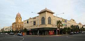 Corner of Moorabool and Malop Streets, Geelong | |||||||||||||||
 Geelong | |||||||||||||||
| Coordinates | 38°09′35″S 144°21′52″E | ||||||||||||||
| Population | 5,210 (2016 census)[1] | ||||||||||||||
| Postcode(s) | 3220 | ||||||||||||||
| LGA(s) | City of Greater Geelong | ||||||||||||||
| State electorate(s) | Geelong | ||||||||||||||
| Federal Division(s) | Corio | ||||||||||||||
| |||||||||||||||
It is the oldest part of Geelong and includes many of the city's important landmarks such as the Geelong Town Hall, St. Mary of the Angels Basilica, the T & G Building, Johnstone Park and the Geelong Botanic Gardens, and the old Geelong Post Office.
The area is one of Geelong's major shopping districts, with the Westfield Geelong and Market Square Shopping Centre catering for shoppers. The opening of the major shopping centres have seen a decline in strip shopping on Moorabool Street, with many empty shops and few customers.[5]
It is also a cultural area for the region, housing the Geelong Art Gallery and the Geelong Performing Arts Centre, as well as the Deakin University waterfront campus. A number of tourist attractions are also nearby, including Waterfront Geelong, Eastern Beach, and the National Wool Museum.Geelong Performing Arts Centre
The Geelong City Centre has seen much redevelopment since 2016. In 2018, Worksafe Headquarters was constructed, drastically changing the skyline. New apartment buildings have come up as well, being The Mercer and The Miramar Apartments. There are many proposals, such as the new Yarra St Pier, and a Hotel Inn. Geelong City Centre, as well as the whole of Geelong, will drastically change over the next 50 years.
Population
In the 2016 Census, there were 5,210 people in the Geelong city centre. 69.5% of people were born in Australia. The next most common countries of birth were England 3.1%, India 2.7%, Italy 2.0% and China 1.9%. 75.5% of people spoke only English at home. Other languages spoken at home included Italian 2.8% and Mandarin 2.4%. The most common responses for religion were No Religion 33.1% and Catholic 26.0%.[1]
References
- Australian Bureau of Statistics (27 June 2017). "Geelong (State Suburb)". 2016 Census QuickStats.

- City of Greater Geelong: Central Geelong revitalisation
- City of Greater Geelong: Central Geelong Activities Area
- "City of Greater Geelong Suburb and Rural District Names and Boundaries" (PDF). Department of Transport, Planning and Local Infrastructure. State Government of Victoria. May 2013. Retrieved 16 May 2015.
- Sophie Smith (2 July 2008). "While Moorabool St remains cold and empty". Geelong News. p. 3.