Batesford, Victoria
Batesford is a small township located approximately 10 kilometres west of Geelong and 67 kilometres south-west of the state capital, Melbourne.
| Batesford Victoria | |||||||||||||||
|---|---|---|---|---|---|---|---|---|---|---|---|---|---|---|---|
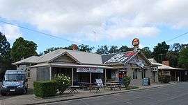 The Dog Rocks Hotel at Batesford | |||||||||||||||
 Batesford | |||||||||||||||
| Coordinates | 38°06′S 144°17′E | ||||||||||||||
| Population | 952 (2016 census)[1] | ||||||||||||||
| Postcode(s) | 3213 | ||||||||||||||
| LGA(s) | |||||||||||||||
| State electorate(s) | |||||||||||||||
| Federal Division(s) | |||||||||||||||
| |||||||||||||||
It is located on the banks of the Moorabool River and on the Midland Highway. The town is divided between the City of Greater Geelong and Golden Plains Shire.
History
Batesford is named after Alfred and John Bates who settled here in 1837 at a place where the river could be forded. The township was surveyed in 1854 and was originally named Hopeton after George Hope whose land it formed a part. A feature of Batesford is the bluestone bridge dating from 1859 which now forms part of the service road past the Dog Rocks Hotel (formerly the Derwent or Batesford Hotel). Both these structures are on the Register of the National Estate.[2] The Post Office opened on 18 August 1856 and closed in 1949.[3]
Batesford features a large granite outcrop. The 'Dog Rocks' is a reserve located within the town that obtained its name from local wild dogs that once lived around the rocks. Indigenous Australian's believe the 'Dog Rocks' to be haunted. Batesford contains the Dogs Rocks Fauna and Flora Sanctuary, which is home to many endemic species. The Dog Rocks Flora and Fauna Sanctuary was established when the current owner George Belcher’s great grandfather purchased the property in 1856. It is situated adjacent to the Dog Rocks outcrop on the top of a hill in west Batesford, west of Geelong, in Victoria. This open eucalyptus woodland nurtures a rich variety of flora and fauna. Rare local native vegetation can be found. The Sanctuary is recognised for its concentration of bird life and provides a protected haven and habitat for them. It also contains a variety of mammals and reptiles which are all part of the complex ecology of the area.
Batesford Today
Batesford in 2019 still has a Hotel and the other campus of Rollins Primary School. The Bell Park Soccer Club play their home games at The Bell Park Sport & Recreation Club even though the grounds are actually in Batesford. Batesford also has a Roadhouse
Heritage listed sites
Batesford contains a number of heritage listed sites, including:
Gallery
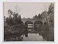 The old Batesford Bridge, built using bluestone in 1859
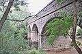 The bridge in 2010
References
- Australian Bureau of Statistics (27 June 2017). "Batesford (State Suburb)". 2016 Census QuickStats. Retrieved 30 August 2017.

- Monash University, Batesford, archived from the original on 11 May 2004, retrieved 12 March 2009
- Premier Postal History, Post Office List, retrieved 11 April 2008
- "Laurence Park Homestead (H0887)". Victorian Heritage Register. Heritage Victoria. Retrieved 3 July 2014.
- "Bridge (H1115)". Victorian Heritage Register. Heritage Victoria. Retrieved 3 July 2014.
- "Railway Viaduct (H1105)". Victorian Heritage Register. Heritage Victoria. Retrieved 3 July 2014.