Fishers Peak
Fishers Peak is the highest summit of Raton Mesa in the Rocky Mountains of North America. The prominent 9,633-foot (2,936 m) peak is located 5.5 miles (8.8 km) south by east (bearing 163°) of the Town of Trinidad in Las Animas County, Colorado, United States. Fishers Peak is higher than any point in the United States east of its longitude.[1][2][3][4]
| Fishers Peak | |
|---|---|
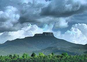 View of Fishers Peak from Trinidad, Colorado | |
| Highest point | |
| Elevation | 9,633 ft (2,936 m) [1][2] |
| Prominence | 1,847 ft (563 m) [3] |
| Isolation | 30.98 mi (49.86 km) [3] |
| Listing | Colorado prominent summits Colorado range high points |
| Coordinates | 37°05′54″N 104°27′46″W [1] |
| Geography | |
 Fishers Peak | |
| Location | Las Animas County, Colorado, United States[4] |
| Parent range | Highest summit of Raton Mesa[3] |
| Topo map | USGS 7.5' topographic map Fishers Peak, Colorado[1] |
| Climbing | |
| Easiest route | hike |
Fishers Peak State Park
In 2020, Colorado Parks and Wildlife established Fishers Peak State Park. The park, which has not yet opened to the public, will occupy the 19,200-acre (7,800 ha) parcel surrounding and including the peak that was formerly a privately-held ranch.[5][6]
See also
References
- "FISHER PEAK". NGS data sheet. U.S. National Geodetic Survey. Retrieved October 20, 2014.
- The elevation of Fishers Peak includes an adjustment of +1.145 m (+3.76 ft) from NGVD 29 to NAVD 88.
- "Fishers Peak, Colorado". Peakbagger.com. Retrieved October 20, 2014.
- "Fishers Peak". Geographic Names Information System. United States Geological Survey. Retrieved October 29, 2014.
- "Agreement Reached on Fisher's Peak / Crazy French Ranch". Great Outdoors Colorado. 2019-01-04. Retrieved 2020-08-14.
- "Fishers Peak". Colorado Parks & Wildlife. Retrieved 2020-08-14.
External links

This article is issued from Wikipedia. The text is licensed under Creative Commons - Attribution - Sharealike. Additional terms may apply for the media files.