Fangshan District
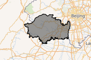
Fangshan District (simplified Chinese: 房山区; traditional Chinese: 房山區; pinyin: Fángshān Qū) is situated in the southwest of Beijing, 38 km (24 mi) away from downtown Beijing. It has an area of 2,019 square kilometres (780 sq mi) and a population of 814,367 (2000 Census). The district is divided into 8 subdistricts, 14 towns, and 6 townships.
Fangshan 房山区 | |
|---|---|
District | |
.JPG) Yanshan Petrochemical Plant | |
| |
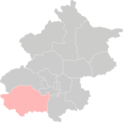 Location of Fangshan District in Beijing | |
| Coordinates (Fangshan government): 39°44′56″N 116°08′36″E | |
| Country | People's Republic of China |
| Municipality | Beijing |
| Township-level divisions | 8 subdistricts 14 towns 6 townships |
| Area | |
| • Total | 2,019 km2 (780 sq mi) |
| Population (2000) | |
| • Total | 814,367 |
| • Density | 400/km2 (1,000/sq mi) |
| Time zone | UTC+8 (China Standard) |
| Area code(s) | 010 |
| Website | www |
Administration
The district administers 8 subdistricts (with 4 subdistricts under Yanshan "area"), 14 towns with 3 towns of which carry the "area" (地区) label, and 6 townships:[1][2]
| Name | Chinese (S) | Hanyu Pinyin | Population (2010)[3] | Area (km2) | |
|---|---|---|---|---|---|
| Gongchen Subdistrict | 拱辰街道 | Gǒngchén Jiēdào | 132,320 | 24.70 | |
| Chengguan Subdistrict | 城关街道 | Chéngguān Jiēdào | 96,243 | 51.00 | |
| Xinzhen Subdistrict | 新镇街道 | Xīnzhèn Jiēdào | 8,842 | 1.72 | |
| Xilu Subdistrict | 西潞街道 | Xīlù Jiēdào | 64,757 | 10.40 | |
| Yanshan Area 燕山地区 Yànshān Dìqū | Xiangyang Subdistrict | 向阳街道 | Xiàngyáng Jiēdào | 8,569 | 116.00 |
| Dongfeng Subdistrict | 东风街道 | Dōngfēng Jiēdào | 24,321 | 1.40 | |
| Yingfeng Subdistrict | 迎风街道 | Yíngfēng Jiēdào | 31,293 | 13.00 | |
| Xingcheng Subdistrict | 星城街道 | Xīngchéng Jiēdào | 21,861 | 0.21 | |
| Liangxiang (town) Area | 良乡(镇)地区 | Liángxiāng (Zhèn) Dìqū | 18,978 | 33.90 | |
| Zhoukoudian (town) Area | 周口店(镇)地区 | Zhōukǒudiàn (Zhèn) Dìqū | 42,840 | 126.00 | |
| Liulihe (town) Area | 琉璃河(镇)地区 | Liúlíhé (Zhèn) Dìqū | 59,931 | 104.00 | |
| Yancun town | 阎村镇 | Yáncūn Zhèn | 48,773 | 48.00 | |
| Doudian town | 窦店镇 | Dòudiàn Zhèn | 65,574 | 64.58 | |
| Shilou town | 石楼镇 | Shílóu Zhèn | 28,902 | 42.50 | |
| Changyang town | 长阳镇 | Zhǎngyáng Zhèn | 64,996 | 98.60 | |
| Hebei town | 河北镇 | Héběi Zhèn | 19,877 | 70.00 | |
| Changgou town | 长沟镇 | Zhǎnggōu Zhèn | 23,791 | 38.70 | |
| Dashiwo town | 大石窝镇 | Dàshíwō Zhèn | 31,139 | 96.00 | |
| Zhangfang town | 张坊镇 | Zhāngfāng Zhèn | 18,446 | 152.40 | |
| Shidu town | 十渡镇 | Shídù Zhèn | 9,778 | 301.00 | |
| Qinglonghu town | 青龙湖镇 | Qīnglónghú Zhèn | 44,598 | 95.83 | |
| Hancunhe town | 韩村河镇 | Háncūnhé Zhèn | 39,210 | 100.67 | |
| Xiayunling Township | 霞云岭乡 | Xiáyúnlǐng Xiāng | 7,140 | 218.00 | |
| Nanjiao Township | 南窖乡 | Nánjiào Xiāng | 3,739 | 40.00 | |
| Fozizhuang Township | 佛子庄乡 | Fúzizhuāng Xiāng | 8,925 | 150.06 | |
| Da'anshan Township | 大安山乡 | Dà'ānshān Xiāng | 11,217 | 70.00 | |
| Shijiaying Township | 史家营乡 | Shǐjiāyíng Xiāng | 6,300 | 110.00 | |
| Puwa Township | 蒲洼乡 | Púwā Xiāng | 2,472 | 96.00 | |
Demography and geography
.JPG)
The Subdistrict area of Fangshan (population 187,667) contains an urban area, has an area of 25 km2 (9.7 sq mi) and an estimated population of 200,000. Other major urban areas are Liangxiang (population estimate 110,000, 93,486 in township), Zhoukoudian (35,000, 39,877 in township), Doudian (30,000, 25,046 in township), and Liulihe (22,000, 37,936 in township).[4]
Fangshan is situated to the east of the Taihang Mountains. The east and south of the district is a fertile plain, with a narrow hilly area running from northeast to southwest. The district has many rivers and lakes; the Juma River, Dashi River, Yongding River, and Xiaoqing River run through the district, assuring abundant water resources.
The location, climate and environment provide good conditions for agriculture. The district produces wheat, rice and various high quality fruits as well as large quantities of animal products. At the moment large investments are made for greenhouse production.
Transportation and telecommunication
Jingguang railway and Jingyuan railway cross the district. In addition, the district is serviced by 4 branch railways and 24 railway stations. Jingshi Expressway also goes through the district. The four main roads are the Jing-Zhou, Jing-Bao, Jing-Yuan, Jing-Liang roads, with branch roads to townships and villages. The total length of roads is up to 1,800 km (1,100 mi). Tanggu Port is only 180 km (110 mi) distant. The programme-controlled telephone capacity supports 128,000 phone sets.
Metro
Fangshan is currently served by two metro lines operated by Beijing Subway:

Economy
In 2017,the regional GDP of the district is 68.17 billion yuan,[5] with GDP per capita at 59.1 thousand yuan.
Historical monuments
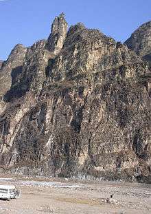
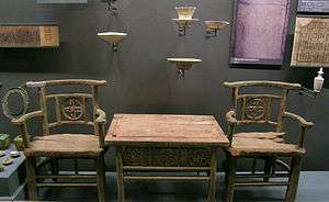
Fangshan district has a long history and many ancient sites. Best known is Zhoukoudian, location of the “Peking Man Site”, which has gained Fangshan the name of “Home of the Dragon”. The 3,000-year-old ruins of the Liulihe Site are housed in the Western Zhou Yan State Capital Museum. The famous Buddhist shrine of Yunju Temple has precious Buddhist relics, including “Sakyamuni’s Bone” and 14,278 stone slabs with sculpted Buddhist sutras. There are also the remains of the Christian (Jingjiao) Monastery of the Cross from the Yuan dynasty. There are many ancient towers, temples, town sites and other sites in Fangshan. Fangshan also has many scenic spots like Shidu’s karst landscape, the unique Stoneflower Cave and natural ancient forests in Shangfang Mountains. Ecologically, Fangshan has 554 kinds of wild plant and 22 kinds of wild animal.
Mineral resources
Fangshan has 2.1 billion tons of coal reserves, which makes it a veritable “coal storehouse” in the west of Beijing; building materials resources are also present in a variety of large deposits. Marble deposits total 450 million cubic meters. A total of 17 kinds have been developed, including “Chinese white marble”, “pink”, “rosy cloud”, and “black jade”. In particular, “Chinese white marble” is famous worldwide and is regarded as a national treasure. There are also large deposits of quartzite (29 million tons); silica (28.6 million tons), granite and buhrstone, in addition to argil, mineral water and slab stones.
Education
- Yanshan Practice Base of Beijing Institute of Petrochemical Technology
Industry and agriculture
Both industry and agriculture are well developed in Fangshan. Over 2300 enterprises owned by the district, townships or villages have been set up and form a complete industrial system in a variety of trades, with different grades and many kinds of products. Yanshan Petrochemical Group, one of the largest state-owned enterprises in China, is located in Fangshan District. Agriculture has developed from traditional growing and planting to integrated and full development in forestry, livestock, greenhouse horticulture and fishery. The building industry has become the backbone of the district, with annual building area reaching 6 million square meters.
The foreign-oriented economy of Fangshan has developed rapidly in recent years. By 1999, the District government had approved 345 foreign-invested enterprises. Over 20 countries and territories throughout five continents are represented. There are 100 export-oriented enterprises producing over 40 kinds of product. Liangxiang Satellite Town, approved by Beijing Municipal Government, has become a new hub of development. In 1998, the site of Fangshan People’s Government moved to Liangxiang, making it the district's center of politics, economics and culture. The development Zone of Liangxiang extends favorable policies to business. Under the Ninth Five-Year Plan and Ten-year Outline, the zone will be further opened to the outside and encourage foreign investment in the following industries: electricity, machinery and electronics, instruments, textiles, printing, new building materials, new materials, new energy resources, fine chemicals, food processing, flowers, greenhouse vegetables, tourist facilities, commercial facilities and the animal industry. The zone welcomes overseas Chinese and guests from Hong Kong, Macau, Taiwan and other countries.
References
- These towns are officially classified as subdistricts, but as they coincide with the area of the same name, they are commonly named "areas" (地区)
- 2011年统计用区划代码和城乡划分代码:房山区 (in Chinese). National Bureau of Statistics of the People's Republic of China. Archived from the original on 2013-05-25. Retrieved 2013-08-07.
- Census Office of the State Council of the People's Republic of China; Population and Employment Statistics Division of the National Bureau of Statistics of the People's Republic of China (2012). 中国2010人口普查分乡、镇、街道资料 (1 ed.). Beijing: China Statistics Print. ISBN 978-7-5037-6660-2.
- Bowman, Harry (2007-02-01). "Harry's World Atlas: China (CN) Beijing Metropolitan Province". Harrysworldatlas.blogspot.com. Retrieved 2013-02-10.
- "Regional Yearbook of Beijing,2018"
External links
| Wikivoyage has a travel guide for Fangshan District. |
| Wikimedia Commons has media related to Fangshan District. |
| Administration |
|  | ||||||
|---|---|---|---|---|---|---|---|---|
| Economy | ||||||||
| Education | ||||||||
| Transportation |
| |||||||
| Visitor attractions |
| |||||||
| Municipal agencies |
| |||||||
| ||||||||
| Authority control |
|
|---|