Downers Grove Township, DuPage County, Illinois
Downers Grove Township is one of nine townships in DuPage County, Illinois, USA. As of the 2010 census, its population was 146,795 and it contained 60,438 housing units.[2] It is the largest township in the county, both in terms of area and population.
Downers Grove Township | |
|---|---|
 Location in DuPage County | |
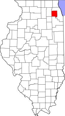 DuPage County's location in Illinois | |
| Coordinates: 41°45′15″N 87°58′32″W | |
| Country | |
| State | |
| County | DuPage |
| Settled | November 6, 1849 |
| Government | |
| • Supervisor | Mark S. Thoman (R) |
| Area | |
| • Total | 50.93 sq mi (131.9 km2) |
| • Land | 49.56 sq mi (128.4 km2) |
| • Water | 1.36 sq mi (3.5 km2) 2.67% |
| Elevation | 758 ft (231 m) |
| Population (2010) | |
| • Estimate (2016)[1] | 148,570 |
| • Density | 2,961.9/sq mi (1,143.6/km2) |
| Time zone | UTC-6 (CST) |
| • Summer (DST) | UTC-5 (CDT) |
| ZIP codes | 60439, 60480, 60514-60517, 60521, 60523, 60527, 60559, 60561 |
| FIPS code | 17-043-20604 |
History
Downers Grove Township is named for Pierce Downer, who settled in the neighborhood about 1830.[3]
In the mid 1800s Dexter Stanley donated land to build the Oak Hill Cemetery. Along with the adjacent Oak Crest Cemetery, both are still used today as Township maintained Cemeteries.[4]
Geography
According to the 2010 census, the township has a total area of 50.93 square miles (131.9 km2), of which 49.56 square miles (128.4 km2) (or 97.31%) is land and 1.36 square miles (3.5 km2) (or 2.67%) is water.[2]
Cities, towns, villages
- Bolingbrook (partial)
- Burr Ridge (west three-quarters)
- Clarendon Hills
- Darien
- Downers Grove (southeast three-quarters)
- Hinsdale (partial)
- Lemont (partial)
- Oak Brook (partial)
- Westmont (south three-quarters)
- Willow Springs (partial, non-residential)
- Willowbrook
- Woodridge (partial)
Unincorporated towns
- Fullersburg at 41.818087°N 87.918394°W
- Lace at 41.751975°N 87.967560°W
- Palisades at 41.713643°N 87.933669°W
(This list is based on USGS data and may include former settlements.)
Extinct towns
(These towns are listed as "historical" by the USGS.)
Cemeteries
The township contains these cemeteries: Cass, Clarendon Hills, Downers Grove, Fullersburg, Hinsdale Animal, Oak Crest, Oak Hill, Pierce Downer, Saint Johns Lutheran, Saint Mary of Gostyn and Saint Patricks Catholic, Zion Lutheran.
Major highways
Airports and landing strips
- Argonne Heliport
- Brookeridge Airpark
- Darien-Woodridge Fire Department Heliport
- Madison Avenue Venture Heliport
- Midwest Heliport
Rivers
Lakes
- Bruce Lake
- Golfview Lake
- Maple Lake
- Picadilly Lake
- Ruth Lake
Landmarks
- Argonne National Laboratory
- Dupage County Waterfall Glen Forest Preserve
School districts
Elementary School Districts: Butler 53, Cass 63, Center Cass 66, 180, Darien 61, Downers Grove Grade 58, Gower 62, Hinsdale 181, Lemont-Bromberek 113A, Maercker 60 High School Districts: CHSD 99, Hinsdale Township 86, Lemont Township 210 Unit School Districts: Westmont Community Unit School District 201
Political districts
- Illinois' 6th Congressional District
- Illinois' 8th Congressional District
- Illinois' 11th Congressional District
- State House District 47
- State House District 81
- State House District 82
- State Senate District 24
- State Senate District 41
References
- "Downers Grove Township, DuPage County, Illinois". Geographic Names Information System. United States Geological Survey. Retrieved 2010-01-10.
- United States Census Bureau 2008 TIGER/Line Shapefiles
- United States National Atlas
- "Population and Housing Unit Estimates". Retrieved June 9, 2017.
- "Population, Housing Units, Area, and Density: 2010 - County -- County Subdivision and Place -- 2010 Census Summary File 1". United States Census. Archived from the original on 2020-02-12. Retrieved 2013-05-28.
- Gannett, Henry (1905). The Origin of Certain Place Names in the United States. Govt. Print. Off. pp. 108.
- "Cemeteries". Downers Grove Township. Downers Grove, Illinois. 2011. Retrieved 7 November 2014.
- "Census of Population and Housing". Census.gov. Retrieved June 4, 2016.
External links
Places adjacent to Downers Grove Township, DuPage County, Illinois | |
|---|---|
Municipalities and communities of DuPage County, Illinois, United States | ||
|---|---|---|
| Cities | Map of Illinois highlighting DuPage County | |
| Villages |
| |
| Townships | ||
| Unincorporated communities | ||
| Ghost towns/Neighborhoods | ||
| Footnotes | ‡This populated place also has portions in an adjacent county or counties | |