Bloomingdale, Illinois
Bloomingdale is a village in DuPage County, Illinois, United States, approximately 25 miles west of Chicago. The population was 22,018 at the 2010 census.
Bloomingdale | |
|---|---|
| Village of Bloomingdale | |
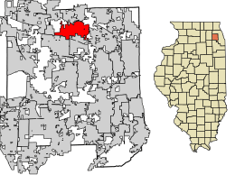 Location of Bloomingdale in DuPage County, Illinois. | |
| Coordinates: 41°56′58″N 88°04′57″W | |
| Country | |
| State | |
| County | DuPage |
| Township | Bloomingdale |
| Settled | 1833 |
| Incorporated | 1889 |
| Re-incorporated | June 18, 1923 |
| Founded by | Meacham Brothers (Lyman, Harvey and Silas) |
| Government | |
| • Type | Council–manager |
| • President | Franco Coladipietro |
| Area | |
| • Total | 7.03 sq mi (18.20 km2) |
| • Land | 6.77 sq mi (17.52 km2) |
| • Water | 0.26 sq mi (0.68 km2) 3.69% |
| Population (2010) | |
| • Total | 22,018 |
| • Estimate (2019)[2] | 21,779 |
| • Density | 3,218.89/sq mi (1,242.87/km2) |
| Up 1.6% from 2000 | |
| Standard of living (2008-12) | |
| • Per capita income | $30,941 |
| • Median home value | $209,200 |
| Time zone | UTC-6 (Central) |
| • Summer (DST) | UTC-5 (Central) |
| ZIP code | 60108 |
| Area codes | 630 and 331 |
| FIPS code | 17-06587 |
| Website | villageofbloomingdale.org |
History
_-_exterior_2.jpg)
Bloomingdale is one of the earliest villages settled in what is now DuPage County. The Meacham family settled here in 1833, and by the end of the following year, 12 to 15 families had settled in the locality. It was originally named Meacham's Grove.[3] The community was served by the Chicago-Galena Highway, modern day Lake Street. It became an important stop for stage coaches and westward travelers. Originally a Cook County settlement, it was annexed by DuPage County in 1839. The northern part of the village wanted to develop commercially while the southern part wished to remain a farming community. In 1923, the village split to accommodate this—the northern portion of the town was incorporated as Roselle. From 1950 to 1980, the population increased from 338 to 12,659.
Points of interest
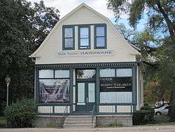
Stratford Square Mall, located at Springfield Road and Schick Road, is the largest of Bloomingdale's shopping centers. The indoor, landscaped mall contains three major department stores and more than 150 specialty shops and restaurants with three vacant anchors, one of which will become a supermarket. Also, Old Town Bloomingdale, at the intersection of Lake Street and Bloomingdale Road, is a collection of small businesses, restaurants and shops located in restored buildings at the original site of the village's first settlement.
Geography
Bloomingdale is located at 41°56′58″N 88°4′57″W (41.949540, -88.082564).[4]
According to the 2010 census, Bloomingdale has a total area of 7.04 square miles (18.23 km2), of which 6.78 square miles (17.56 km2) (or 96.31%) is land and 0.26 square miles (0.67 km2) (or 3.69%) is water.[5]
Demographics
| Historical population | |||
|---|---|---|---|
| Census | Pop. | %± | |
| 1880 | 226 | — | |
| 1890 | 403 | 78.3% | |
| 1900 | 235 | −41.7% | |
| 1910 | 462 | 96.6% | |
| 1920 | 448 | −3.0% | |
| 1930 | 337 | −24.8% | |
| 1940 | 305 | −9.5% | |
| 1950 | 339 | 11.1% | |
| 1960 | 1,262 | 272.3% | |
| 1970 | 2,974 | 135.7% | |
| 1980 | 12,656 | 325.6% | |
| 1990 | 16,614 | 31.3% | |
| 2000 | 21,675 | 30.5% | |
| 2010 | 22,018 | 1.6% | |
| Est. 2019 | 21,779 | [2] | −1.1% |
| U.S. Decennial Census[6] | |||
As of the census[7] of 2000, there were 21,675 people, 8,219 households, and 5,662 families residing in the village. The population density was 3,204.1 people per square mile (1,238.0/km2). There were 8,399 housing units at an average density of 1,241.6 per square mile (479.7/km2). The racial makeup of the village was 85.37% White, 2.57% African American, 0.12% Native American, 8.84% Asian, 0.01% Pacific Islander, 1.50% from other races, and 1.58% from two or more races. Hispanic or Latino of any race were 4.96% of the population.
There were 8,219 households, out of which 30.0% had children under the age of 18 living with them, 57.4% were married couples living together, 8.4% had a female householder with no husband present, and 31.1% were non-families. 24.3% of all households were made up of individuals, and 6.8% had someone living alone who was 65 years of age or older. The average household size was 2.54 and the average family size was 3.08.
In the village, the population was spread out, with 21.7% under the age of 18, 8.3% from 18 to 24, 31.1% from 25 to 44, 26.5% from 45 to 64, and 12.4% who were 65 years of age or older. The median age was 38 years. For every 100 females, there were 92.9 males. For every 100 females age 18 and over, there were 89.4 males.
The median income for a household in the village was $51,365, and the median income for a family was $78,889 (these figures had risen to $73,324 and $86,560 respectively as of a 2007 estimate[8]). Males had a median income of $52,729 versus $35,827 for females. The per capita income for the village was $30,941. About 1.8% of families and 2.7% of the population were below the poverty line, including 2.6% of those under age 18 and 3.0% of those age 65 or over.
Education
Elementary school districts serving Bloomingdale include:[9]
- Bloomingdale School District 13
- Community Consolidated School District 93
- It is headquartered in Bloomingdale and operates two schools in Bloomingdale: Stratford Middle School and the Early Childhood Center.
- Keeneyville School District 20
- Marquardt School District 15
- It operates Winnebago Elementary School in Bloomingdale.
- Medinah District 11
High school districts include:[9]
- Glenbard Township High School District 87
- Students in the section of Bloomingdale within District 87 are zoned to either Glenbard East High School in Lombard or Glenbard North High School in Carol Stream.[10][11]
- Lake Park High School (District 108) in Roselle
Bloomingdale has one private school, St. Isidore School.[9]
Nearby private schools:[9]
- St. Francis High School in Wheaton
- St. Matthew School in Glendale Heights
- St. Walter Catholic School in Roselle
- Trinity Lutheran School in Roselle
The community is served by the 35,000-square-foot (3,300 m2) Bloomingdale Public Library.[12]
Religious Institutions
Religious institutions found within the village of Bloomingdale include:[13]
- Bloomingdale Church
- Bloomingdale Community Church
- Church of the Incarnation (Episcopal)
- Church of Jesus Christ of Latter Day Saints
- Cornerstone Faith Community Church
- Mission Church[14]
- Shree Radhey Shyam Temple
- St. Andrew's Ukranian Orthodox Church
- St. Isidore's Roman Catholic Church
- World Mission Society Church of God
Notable people
- Nate Fox, professional basketball player[15]
- Austin Jones, YouTuber and musician[16]
- Frank C. Rathje, president of the American Bankers Association, founder of the Mutual National Bank of Chicago
References
- "2019 U.S. Gazetteer Files". United States Census Bureau. Retrieved July 14, 2020.
- "Population and Housing Unit Estimates". United States Census Bureau. May 24, 2020. Retrieved May 27, 2020.
- "Several Towns Named After Founders and Heroes". The Daily Herald. December 28, 1999. p. 220. Retrieved August 17, 2014 – via Newspapers.com.

- "US Gazetteer files: 2010, 2000, and 1990". United States Census Bureau. 2011-02-12. Retrieved 2011-04-23.
- "G001 - Geographic Identifiers - 2010 Census Summary File 1". United States Census Bureau. Archived from the original on 2020-02-13. Retrieved 2015-08-02.
- "Census of Population and Housing". Census.gov. Retrieved June 4, 2015.
- "U.S. Census website". United States Census Bureau. Retrieved 2008-01-31.
- http://factfinder.census.gov/servlet/ACSSAFFFacts?_event=Search&geo_id=16000US1356168&_geoContext=01000US%7C04000US13%7C16000US1356168&_street=&_county=bloomingdale&_cityTown=bloomingdale&_state=04000US17&_zip=&_lang=en&_sse=on&ActiveGeoDiv=geoSelect&_useEV=&pctxt=fph&pgsl=160&_submenuId=factsheet_1&ds_name=ACS_2007_3YR_SAFF&_ci_nbr=null&qr_name=null®=null%3Anull&_keyword=&_industry=%5B%5D
- "Bloomingdale Area Schools." Village of Bloomingdale, Illinois. Retrieved on June 20, 2017. See: School district map which indicates elementary school and high school districts
- "Boundary Map Archived 2016-03-22 at the Wayback Machine." Glenbard Township High School District 87. Retrieved on June 20, 2017.
- "Zoning." Village of Bloomingdale, Illinois. Retrieved on June 20, 2017. Shows the exact village boundaries.
- "Bloomingdale Public Library." Village of Bloomingdale, Illinois. Retrieved on June 20, 2017.
- "Churches | Bloomingdale, IL - Official Website". www.villageofbloomingdale.org. Retrieved 2020-08-14.
- "Mission Church". Mission Church. Retrieved 2020-08-14.
- Fornek, Kimberly. "Hinsdale businessman sentenced to 70 years in murder of supposed romantic rival". chicagotribune.com. Retrieved 10 December 2017.
- Seidel, Jon (13 June 2017). "YouTube star Austin Jones charged with child porn counts in Chicago". Chicago Sun-Times.
External links
- Village of Bloomingdale official website
- Bloomingdale Historical Society
- Bloomingdale Public Library official website
- Bloomingdale School District 13
- Images of historic Bloomingdale from the Bloomingdale Heritage Collection at Bloomingdale Public Library
Municipalities and communities of DuPage County, Illinois, United States | ||
|---|---|---|
| Cities | Map of Illinois highlighting DuPage County | |
| Villages |
| |
| Townships | ||
| Unincorporated communities | ||
| Ghost towns/Neighborhoods | ||
| Footnotes | ‡This populated place also has portions in an adjacent county or counties | |
| Major city |  | |
|---|---|---|
| Cities (over 30,000 in 2010) | ||
| Towns and villages (over 30,000 in 2010) |
| |
| Counties | ||
| Regions |
| |
| Sub-regions | ||
| Authority control |
|
|---|