Dampier County

Dampier County is one of the 141 Cadastral divisions of New South Wales. The Deua River is the northern boundary, with land slightly to the north of the Brogo River the southern boundary. It includes Bermagui, Narooma, Bodalla, and most of the Deua National Park and Wadbilliga National Park.

Dampier
New South Wales
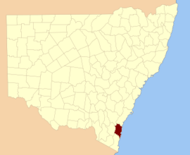
Location in New South Wales
Lands administrative divisions around Dampier:
Murray St. Vincent Pacific Ocean
Beresford Dampier Pacific Ocean
Auckland Auckland Pacific Ocean

Dampier County was named in honour of seaman William Dampier (1651-1715).[1]

Parishes within this county

A full list of parishes found within this county; their current LGA and mapping coordinates to the approximate centre of each location is as follows:

ParishLGACoordinates
BadjaEurobodalla Shire36°03′54″S 149°36′04″E
BelowraEurobodalla Shire36°08′54″S 149°43′04″E
BergaliaEurobodalla Shire35°58′54″S 150°02′04″E
BermaguiBega Valley Shire36°24′54″S 150°00′04″E
BodallaEurobodalla Shire36°06′54″S 150°04′04″E
BumboEurobodalla Shire36°03′54″S 150°00′04″E
Bumbo WestEurobodalla Shire36°00′54″S 149°51′04″E
BurraEurobodalla Shire35°53′54″S 149°57′04″E
CadgeeEurobodalla Shire36°10′54″S 149°51′04″E
CadjangarryBega Valley Shire36°27′54″S 149°56′04″E
CongoEurobodalla Shire35°58′54″S 150°07′04″E
CoondellaEurobodalla Shire35°57′54″S 149°48′04″E
CounteganySnowy Monaro Regional Council36°18′54″S 149°35′04″E
CurmuleeEurobodalla Shire35°49′54″S 149°45′04″E
CurrambeneQueanbeyan-Palerang Regional Council35°56′54″S 149°34′04″E
DeuaEurobodalla Shire35°53′54″S 149°49′04″E
DolondundaleSnowy Monaro Regional Council36°18′54″S 149°28′04″E
DonovanEurobodalla Shire35°49′54″S 149°56′04″E
EurobodallaEurobodalla Shire36°12′54″S 149°55′04″E
GuineaSnowy Monaro Regional Council36°11′54″S 149°32′04″E
GulphEurobodalla Shire36°04′54″S 149°51′04″E
JillagaQueanbeyan-Palerang Regional Council36°00′54″S 149°38′04″E
JindenSnowy Monaro Regional Council35°51′54″S 149°33′04″E
MerricumbeneEurobodalla Shire35°45′54″S 149°51′04″E
MoruyaEurobodalla Shire35°55′54″S 150°06′04″E
MurrabrineBega Valley Shire36°25′54″S 149°49′04″E
MurrahBega Valley Shire36°31′54″S 150°00′04″E
NariraBega Valley Shire36°23′54″S 149°54′04″E
NaroomaEurobodalla Shire36°14′54″S 150°04′04″E
NerrigundahEurobodalla Shire36°06′54″S 150°00′04″E
ShoalhavenQueanbeyan-Palerang Regional Council35°55′54″S 149°38′04″E
TanjaBega Valley Shire36°35′54″S 150°00′04″E
UranbeneEurobodalla Shire35°58′54″S 149°43′04″E
WadbilligaBega Valley Shire36°11′54″S 149°36′04″E
Wadbilliga WestBega Valley Shire36°14′09″S 149°35′27″E
WagongaEurobodalla Shire36°11′54″S 150°05′04″E
WambanEurobodalla Shire35°57′54″S 149°57′04″E
WandellaBega Valley Shire36°17′54″S 149°52′04″E
WapengoBega Valley Shire36°33′54″S 149°55′04″E
WyanbeneEurobodalla Shire35°46′54″S 149°44′04″E
YowrieBega Valley Shire36°19′54″S 149°45′04″E

References

  1. "Dampier". Geographical Names Register (GNR) of NSW. Geographical Names Board of New South Wales. Retrieved 4 August 2013.
This article is issued from Wikipedia. The text is licensed under Creative Commons - Attribution - Sharealike. Additional terms may apply for the media files.