Cummertrees
Cummertrees is a coastal village and civil parish of Annandale in the historical county of Dumfriesshire in Dumfries and Galloway. It lies about 1 mile (1.6 km) inland, on the Pow Water, 12 miles (19 km) from Dumfries and 3 miles (5 km) from Annan.[1]
| Cummertrees | |
|---|---|
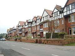 Seaside-style holiday houses in Cummertrees's Queensberry Terrace | |
 Cummertrees Location within Dumfries and Galloway | |
| OS grid reference | NY141664 |
| Council area | |
| Lieutenancy area | |
| Country | Scotland |
| Sovereign state | United Kingdom |
| Post town | ANNAN |
| Postcode district | DG12 |
| Police | Scotland |
| Fire | Scottish |
| Ambulance | Scottish |
| UK Parliament | |
| Scottish Parliament | |
Etymology
Cummertrees, recorded as Cumbertres in 1204 and 1207, is probably of Cumbric origin.[2] The second element represents *tres 'strife, tumult, violence', cognate with Welsh tres and Gaelic treas.[2][3][4] The first element is *cümber, cömber 'confluence.[2][4][5] Andrew Breeze proposes the meaning 'confluence of turbulent water'.[2] Alan James suggests that *tres may have been a stream-name.[3]
However, James notes that the first element may represent *cömbröɣ, which occurs in the name Cumbria.[6][7]
History
Cummertrees is rural, primarily residential village; the parish includes Powfoot and Trailtrow and is bounded by St Mungo and Hoddam, Annan, the Solway Firth, and Ruthwell and Dalton. A Public hall was erected at Cummertrees in 1893.[1] The river Annan is at the northern boundary. It has a wide area of level sand swept by the Solway 'bore' which can move at around ten miles an hour and can often be heard throughout the parish. The seaboard is low and sandy and features in Walter Scott's novel Redgauntlet. The ground rises a little inland, to 350 feet (107 m) on Repentance Hill.[1]
The local geology is mainly Devonian, with old limestone workings at Kelhead and some sandstone quarries.[1]
In a field called Bruce's Acres, at Broom Farm, Robert Bruce fought and lost a skirmish against the Southron (English).[1]
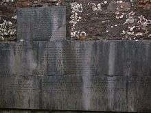
Cummertrees parish includes some notable buildings, Hoddam Castle, Kinmount House and Murraythwaite. Historically, the main landowner has been the Marquess of Queensberry. A nearby caravan park has been named in his memory . The church was founded by Robert Bruce and has been much rebuilt and enlarged.[1] The Douglas Family Mausoleum at Cummertrees parish church is traditional burial place of the Marquesses of Queensberry. There is also a private family burial ground dating from the mid 19th century for the Queensberry family on Gooley Hill within the policies of Kinmount House.
Kinmount House
Kinmount House was the seat of the Marquesses of Queensberry, described by Groome in 1903 as a beautiful edifice, built in the early part of the 19th century at a cost of £40,000, and surrounded by fine pleasure grounds.[8]
Transport
Cummertrees railway station was opened in 1848 by the Glasgow, Dumfries and Carlisle Railway, which then became part of the Glasgow and South Western Railway. It was closed by the British Railways Board in 1955. The fine station building survives as a private residence.
Views of Cummertrees
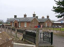 The old Cummertrees railway station.
 The parish church and lychgate.
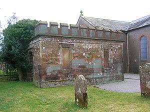 The Douglas Family Mausoleum at Cummertrees Parish Church, traditional burial place of the Marquesses of Queensberry.
 Holiday apartments at Agnes Hill.
Notable residents
- Lady Florence Dixie (1855-1905), travel writer, war correspondent, and feminist, a daughter of the 8th Marquess of Queensberry, was born and lived much of her later life on the Kinmount estate at Glenstewart House after her husband lost his family seat through gambling. She had married Sir Alexander Beaumont Churchill Dixie, 11th Baronet (1851-1924), known as "Sir A.B.C.D."
- Lord Francis Douglas (1847 – 14 July 1865) was a British mountaineer born in Cummertrees. After sharing in the first ascent of the Matterhorn, he died in a fall on the way down from the summit, aged just eighteen.
- Steve Ovett lived at Kinmount House from 1988-1998.
References
- Groome, Francis H. Ordnance Gazetteer of Scotland: A Survey of Scottish Topography, Statistical, Biographical, and Historical. II. London: William Mackenzie. p. 327.
- Breeze, Andrew (2005). "Brittonic Place-Names from South-West Scotland, Part 6: Cummertrees, Beltrees, Trevercarcou" (PDF). Transactions and Journal of Proceedings of the Dumfriesshire and Galloway Natural History and Antiquarian Society. Third Series. LXXIX: 91. Archived from the original (PDF) on 2014-08-31.
- James, Alan G. (2014). The Brittonic Language in the Old North: A Guide to the Place-Name Evidence (PDF). Volume 2: Guide to the Elements. p. 367. Archived from the original (PDF) on 2014-09-11.
- Watson, William J. (1925). "The Celts (British and Gael) in Dumfriesshire and Galloway" (PDF). Transactions and Journal of Proceedings of the Dumfriesshire and Galloway Natural History and Antiquarian Society. Third Series. XI: 147. Archived from the original (PDF) on 2014-08-31.
- James, Alan G. (2014). The Brittonic Language in the Old North: A Guide to the Place-Name Evidence (PDF). Volume 2: Guide to the Elements. p. 109. Archived from the original (PDF) on 2014-09-11.
- James, Alan G. (2014). The Brittonic Language in the Old North: A Guide to the Place-Name Evidence (PDF). Volume 2: Guide to the Elements. p. 110. Archived from the original (PDF) on 2014-09-11.
- James, Alan G. (2013). "P-Celtic in Southern Scotland and Cumbria: A review of the place-name evidence for possible Pictish phonology" (PDF). The Journal of Scottish Name Studies: 45. Archived from the original (PDF) on 2015-04-02.
- Groome, Page 964
External links
| Wikimedia Commons has media related to Cummertrees. |