Covington, Louisiana
Covington is a city in, and the parish seat of, St. Tammany Parish, Louisiana, United States.[3] The population was 8,765 at the 2010 census.[4] It is located at a fork of the Bogue Falaya and the Tchefuncte River.
Covington, Louisiana | |
|---|---|
City | |
| City of Covington | |
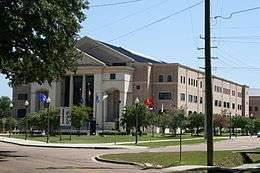 St. Tammany Parish Justice Center | |
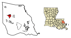 Location of Covington in St. Tammany Parish, Louisiana. | |
.svg.png) Location of Louisiana in the United States | |
| Coordinates: 30°28′44″N 90°06′15″W | |
| Country | United States |
| State | Louisiana |
| Parish | St. Tammany |
| Founded | 1813 |
| Government | |
| • Mayor | Mark R. Johnson |
| Area | |
| • Total | 8.25 sq mi (21.37 km2) |
| • Land | 8.07 sq mi (20.91 km2) |
| • Water | 0.18 sq mi (0.46 km2) |
| Elevation | 26 ft (8 m) |
| Population (2010) | |
| • Total | 8,765 |
| • Estimate (2019)[2] | 10,564 |
| • Density | 1,308.72/sq mi (505.31/km2) |
| Time zone | UTC-6 (CST) |
| • Summer (DST) | UTC-5 (CDT) |
| ZIP codes | 70433, 70434, 70435 |
| Area code(s) | 985 |
| FIPS code | 22-18125 |
| Website | http://www.covla.com |
Covington is part of the New Orleans–Metairie–Kenner Metropolitan Statistical Area.
History
The earliest known settlement by Europeans in the area was in 1800 by Jacques Drieux, during the British West Florida period.
In 1813, John Wharton Collins established a town with the name of Wharton. He is buried on the corner of the city cemetery directly across from the Covington Police Department. There are conflicting stories about how the city came to be named Covington. Many historians believe the city was renamed for General Leonard Covington, a hero of the War of 1812.[5][6] (Covington was killed late in 1813, having established his home in the Mississippi Territory.)
Local historian Judge Steve Ellis floats another theory centered on the suggestion by Jesse Jones, a local attorney, that the city be named in honor of the Blue Grass whiskey---made in Covington, Kentucky---enjoyed by town officials.[7] In any case, Leonard Covington is the namesake of both towns.[6]
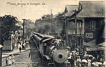
Originally, commerce was brought to Covington via boat up the Bogue Falaya River, which used the Tchefuncte River as a means of passage to and from Lake Pontchartrain. Then in 1888, the railroad came to town. Much of the former railroad right-of-way is now occupied by the Tammany Trace, a thirty-one mile bike trail running east and west through several communities on the north side of Lake Pontchartrain.
In the late 20th century, with the expansion of Louisiana's road system, many people who worked in New Orleans started living in Covington, commuting to work via the Lake Pontchartrain Causeway . With the expansion of the interstate system, Covington experienced a boom of growth. Many people moved to the Northshore for more affordable housing, larger lot size and a small town feeling. This is considered to be associated with white flight out of New Orleans, though the Jefferson Parish area saw the most expansion during that period.[8]
Hurricane Katrina
Hurricane Katrina made landfall near Slidell, but Covington was sufficiently elevated to escape the massive storm surge; however, the city suffered devastating wind damage. Following the storm, Covington, along with the rest of the North Shore of Lake Pontchartrain, experienced a population boom as a result of many former inhabitants of the New Orleans area being forced to move out of their storm-ravaged homes. The town's population continues to grow.
Geography
According to the United States Census Bureau, the city has a total area of 8.2 square miles (21.2 km2), of which 8.0 square miles (20.7 km2) is land and 0.23 square miles (0.6 km2), or 2.60%, is water.[9]
Demographics
| Historical population | |||
|---|---|---|---|
| Census | Pop. | %± | |
| 1870 | 585 | — | |
| 1880 | 567 | −3.1% | |
| 1890 | 976 | 72.1% | |
| 1900 | 1,205 | 23.5% | |
| 1910 | 2,601 | 115.9% | |
| 1920 | 2,942 | 13.1% | |
| 1930 | 3,208 | 9.0% | |
| 1940 | 4,123 | 28.5% | |
| 1950 | 5,113 | 24.0% | |
| 1960 | 6,754 | 32.1% | |
| 1970 | 7,170 | 6.2% | |
| 1980 | 7,892 | 10.1% | |
| 1990 | 7,691 | −2.5% | |
| 2000 | 8,483 | 10.3% | |
| 2010 | 8,765 | 3.3% | |
| Est. 2019 | 10,564 | [2] | 20.5% |
| U.S. Decennial Census[10] | |||
As of the census[11] of 2000, there were 8,483 people, 3,258 households, and 2,212 families residing in the city. The population density was 1,248.0 people per square mile (481.7/km2). There were 3,565 housing units at an average density of 524.5 per square mile (202.4/km2). The racial makeup of the city was 77.45% White, 20.17% African American, 0.33% Native American, 0.34% Asian, 0.04% Pacific Islander, 0.25% from other races, and 1.43% from two or more races. Hispanic or Latino of any race were 1.56% of the population.
There were 3,258 households, out of which 33.8% had children under the age of 18 living with them, 46.8% were married couples living together, 17.2% had a female householder with no husband present, and 32.1% were non-families. 27.5% of all households were made up of individuals, and 9.9% had someone living alone who was 65 years of age or older. The average household size was 2.52 and the average family size was 3.10.
In the city, the population was spread out, with 26.8% under the age of 18, 8.5% from 18 to 24, 26.1% from 25 to 44, 24.1% from 45 to 64, and 14.5% who were 65 years of age or older. The median age was 38 years. For every 100 females, there were 86.8 males. For every 100 females age 18 and over, there were 80.0 males.
The median income for a household in the city was $36,949, and the median income for a family was $50,332. Males had a median income of $36,434 versus $23,859 for females. The per capita income for the city was $21,438. About 11.8% of families and 16.1% of the population were below the poverty line, including 23.5% of those under age 18 and 17.2% of those age 65 or over.
Points of interest
A 10-foot-tall (3.0 m) statue of Ronald Reagan on a 6-foot (1.8 m) base is reputed to be the world's largest of the former president.[12]
The Covington trail head is the start of Tammany Trace, a 31-mile paved rails-to-trails path for hikers and bicyclists, which connects Covington with Mandeville, Abita Springs, Lacombe and Slidell.[13]
Economy
Zen-Noh Grain Corporation, a subsidiary of the Japanese cooperative Zen-Noh, is headquartered in Covington.[14]
Education
St. Tammany Parish Public Schools operates public schools in Covington.
- Covington High School (9-12)[15]
- Pitcher Junior High School (7-8)[16]
- Pine View Middle School (4-6)[17]
- Covington Elementary School (K-3)[18]
- Lyon Elementary School (K-3)[19]
Lee Road Junior High School has a Covington address but is outside the city limits and not serving any portion of the city.[20]
Notable people
- Peggy Dow (Peggy Varnadow Helmerich), film actress and philanthropist, lived much of her childhood in Covington
- Frank Burton Ellis, state senator (1940–1944), U.S. District Court judge, 1962–1965
- Dave Fortman, guitarist for the band Ugly Kid Joe and current American music producer, graduated from Covington High School
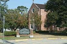
- Elizabeth Futral, opera soprano reared in Covington. Her father was minister of the Covington First Baptist Church for many years.
- Daniel F. Galouye, science fiction writer
- Katherine Haik, Miss Teen USA 2015
- Robert Higgs, economist. Lived in Covington for several years.
- Pete Maravich, NBA all-star, lived in Covington until his death in 1988
- Patrick Moore, essayist, satirist and good guy. Resides in Covington.
- Walker Percy, author and essayist, lived in Covington until his death in 1990
- Harry Reeks, landscape painter and combat artist for the U.S. Marine Corps.[21]
- Leon Rene, songwriter
- Amy Serrano, filmmaker, poet, essayist, and humanitarian
- Amanda Shaw, Cajun fiddler, singer, and actress
- Ian Somerhalder, actor and model, born in Covington
- Stephen Stills, musician
- Michael G. Strain, veterinarian, Republican politician and current Commissioner of the Louisiana Department of Agriculture and Forestry.
- Hank Stram, NFL Hall of Fame Coach. Lived in Covington until his death in July 2005
- Lauren Turner, singer/songwriter, American Idol contestant season 10, graduated from Covington High School
- Greta Valenti, television producer
- Theo Von, comedian, grew up in Covington
Movies filmed in Covington
- 1995 — Dead Man Walking
- 1995 — Kingfish: A Story of Huey P. Long
- 1997 — Eve's Bayou
- 2005 — Local Color
- 2008 — The Yellow Handkerchief
- 2009 — I Love You Phillip Morris
- 2010 — The Pregnancy Pact
- 2012 — The Lucky One
- 2013 — Beautiful Creatures
- 2014 — American Ultra[22]
- 2015 — Joe Dirt 2
- 2019 — The Highwaymen
References
- "2019 U.S. Gazetteer Files". United States Census Bureau. Retrieved July 25, 2020.
- "Population and Housing Unit Estimates". United States Census Bureau. May 24, 2020. Retrieved May 27, 2020.
- "Find a County". National Association of Counties. Archived from the original on May 31, 2011. Retrieved 2011-06-07.
- "Profile of General Population and Housing Characteristics: 2010 Demographic Profile Data (DP-1): Covington city, Louisiana". United States Census Bureau. Retrieved February 17, 2012.
- StoppingPoints.com. "Covington Historical Marker".
- Leeper, Clare D'Artois (2012). Louisiana Place Names: Popular, Unusual, and Forgotten Stories of Towns, Cities, Plantations, Bayous, and Even Some Cemeteries. LSU Press. p. 75. ISBN 978-0-8071-4740-5.
- City of Covington (Homepage). "History of the City of Covington".
- Greater New Orleans Community Data Center. "White Flight".
- "Geographic Identifiers: 2010 Demographic Profile Data (G001): Covington city, Louisiana". United States Census Bureau. Retrieved February 17, 2012.
- "Census of Population and Housing". Census.gov. Retrieved June 4, 2015.
- "U.S. Census website". United States Census Bureau. Retrieved 2008-01-31.
- "World's Largest Ronald Reagan Statue, Covington, Louisiana".
- "Things to do in Covington". 1stLake.com. Retrieved 17 March 2015.
- "Corporate Headquarters". Zen-Noh Grain Corporation. Retrieved 2020-05-08.
- Covington High School Boundary . St. Tammany Parish Public Schools. Retrieved on July 7, 2018.
- "Pitcher Junior High School map". St. Tammany Parish Public Schools. Retrieved 2020-05-08.
- "Pine View Middle School". St. Tammany Parish Public Schools. Retrieved 2020-05-08.
- "Covington Elementary School". St. Tammany Parish Public Schools. Retrieved 2020-05-08.
- "Lyon Elementary School". St. Tammany Parish Public Schools. Retrieved 2020-05-08.
- "Lee Road Junior High School map". St. Tammany Parish Public Schools. Retrieved 2020-05-08.
- Bellande, Ray L. "Harry Del Reeks (1920 - 1982)". Ocean Springs Archives. Retrieved February 17, 2014.
- "American Ultra". Backstage. Retrieved September 27, 2014.
External links
![]()
- City of Covington official website
- Covington Business Association
- Inside Northside special issue, Covington 1813–2013
Municipalities and communities of St. Tammany Parish, Louisiana, United States | ||
|---|---|---|
Parish seat: Covington | ||
| Cities | 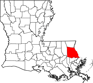 | |
| Towns | ||
| Villages | ||
| CDPs | ||
| Unincorporated communities | ||

| Authority control |
|
|---|