City Hall station (IRT Lexington Avenue Line)
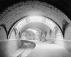
City Hall, also known as City Hall Loop, was the original southern terminal station of the first line of the New York City Subway, built by the Interborough Rapid Transit Company (IRT), named the "Manhattan Main Line", and now part of the IRT Lexington Avenue Line. Opened on October 27, 1904, this station, located underneath the public area in front of City Hall, was designed to be the showpiece of the new subway. The platform and mezzanine feature Guastavino tile, skylights, colored glass tilework, and brass chandeliers. The Rafael Guastavino-designed station is unique in the system for the usage of Romanesque Revival architecture.
City Hall | |
|---|---|
| Former New York City Subway station | |
.jpg) Seen in 2018 | |
| Station statistics | |
| Address | Park Row & City Hall Park New York, NY |
| Borough | Manhattan |
| Locale | Civic Center |
| Division | A (IRT) |
| Line | IRT Lexington Avenue Line |
| Services | None (abandoned) |
| Structure | Underground |
| Platforms | 1 side platform |
| Tracks | 1 balloon loop |
| Other information | |
| Opened | October 27, 1904[1] |
| Closed | December 31, 1945[2] |
| Station succession | |
| Next north | Brooklyn Bridge–City Hall |
| Next south | (Terminal) |
| ---- | |
City Hall Subway Station (IRT)[3] | |
New York City Landmark No. 1096 | |
| Location | New York City, New York |
| Coordinates | 40°42′48″N 74°00′24″W |
| Built | 1904 |
| Architect | Heins & LaFarge |
| Architectural style | Romanesque Revival |
| MPS | New York City Subway System MPS |
| NRHP reference No. | 04001010 |
| NYCL No. | 1096 |
| Significant dates | |
| Added to NRHP | September 17, 2004 |
| Designated NYCL | November 24, 1981[4] |
The station was built on a curve and could only accommodate five-car trains of 257 feet (78 m), which proved to be inefficient as subway ridership grew and trains were lengthened to 10 cars. Due to the infrastructural shortfalls, as well as its proximity to the nearby Brooklyn Bridge station, passenger service was discontinued on December 31, 1945, although the station is still used as a turning loop for the 6 and <6> trains.
History


The station had always been envisioned as a terminal with loop tracks. The initial plan called for four tracks on a loop. When the plans for the Lexington Avenue Line were changed in 1898 to allow the express tracks to go to Brooklyn as part of the Interborough Rapid Transit Company (IRT)'s Contract 2, plans were changed so that the station only served local trains, which operated along a single track.[4]:5
Construction
The official start of construction took place on March 24, 1900, at the front steps of City Hall, at a ceremony officiated by then-Mayor Robert Van Wyck.[5]
Operation of the first subway began on October 27, 1904, with the opening of the original 28 stations of the New York City Subway from City Hall to 145th Street on the West Side Branch.[6][7] The opening ceremonies, held the day before, were attended by Mayor George B. McClellan Jr..[1] More than 15,000 people were issued passes for the first series of rides from the platform. At precisely 2:35 pm, the first subway train departed from City Hall station with Mayor McClellan at the controls. The event was so heavily attended that police Commissioner McAdoo said every policeman in the city was on duty all day and far into the night.[8] At the time of the opening, President A. E. Orr of the Rapid Transit Board requested that all New Yorkers join in the celebration by blowing whistles and ringing bells.[9] At street level, in the pavement in front of City Hall, a plaque can still be seen commemorating groundbreaking for the subway in 1900.[10]
At the time, the station was also called "City Hall Loop".[11] Unlike the rest of the subway line, the City Hall station had tall tile arches, brass fixtures, chandeliers, skylights, polychrome tile, and elegant curves that ran along the platform. It was lit by wrought iron chandeliers and the three skylights of cut amethyst glass that allowed sunshine onto parts of the platform.[12] During World War II, the skylights were blacked out with tar for safety.
Closure
In the years after the line's construction, increased subway ridership led to longer trains, and thus longer platforms, in the 1940s and early 1950s.[13] The City Hall station, built on a tight curve, would have been difficult to lengthen, and it was also quite close to the far busier Brooklyn Bridge–City Hall station.[14] In addition, the new, longer trains had center doors in each car, which were an unsafe distance from the platform edge. Movable platform extensions were installed to fill the gap.
City Hall, notwithstanding its architectural grandeur, was never an important station. In its final year of use, it served only 600 passengers per day[13] and was not open at nights (when trains continued to the loop station at South Ferry). The Brooklyn Bridge station, located a short walk away, at the opposite end of City Hall Park, was more popular, as it provided both local and express service, including trains to Brooklyn. The Brooklyn Bridge streetcar terminal and Park Row station on the BMT elevated lines were above for easy transfers.[13] Given the extensive renovations that would have been required to bring the station up to modern standards, the city decided to close it instead. The final day of service was December 31, 1945.[13][2][15]
In the 1980s, Mayor Ed Koch suggested allowing a restaurant to open in the old station, but the idea was overruled by the New York City Police Department, who expressed concerns about security due to its location below City Hall.[14]
Current status
Track layout | |||||||||||||||||||||||||||||||||||||||||||||||||||||||||||||||||||||||||||||||||||||||||||||||||||||||||||||||||||||||||||||||||||||||||||||||||||||||||||||||||||||||||||||||||||||||||||||||||||||||||||||||||||||||||
|---|---|---|---|---|---|---|---|---|---|---|---|---|---|---|---|---|---|---|---|---|---|---|---|---|---|---|---|---|---|---|---|---|---|---|---|---|---|---|---|---|---|---|---|---|---|---|---|---|---|---|---|---|---|---|---|---|---|---|---|---|---|---|---|---|---|---|---|---|---|---|---|---|---|---|---|---|---|---|---|---|---|---|---|---|---|---|---|---|---|---|---|---|---|---|---|---|---|---|---|---|---|---|---|---|---|---|---|---|---|---|---|---|---|---|---|---|---|---|---|---|---|---|---|---|---|---|---|---|---|---|---|---|---|---|---|---|---|---|---|---|---|---|---|---|---|---|---|---|---|---|---|---|---|---|---|---|---|---|---|---|---|---|---|---|---|---|---|---|---|---|---|---|---|---|---|---|---|---|---|---|---|---|---|---|---|---|---|---|---|---|---|---|---|---|---|---|---|---|---|---|---|---|---|---|---|---|---|---|---|---|---|---|---|---|---|---|---|
| |||||||||||||||||||||||||||||||||||||||||||||||||||||||||||||||||||||||||||||||||||||||||||||||||||||||||||||||||||||||||||||||||||||||||||||||||||||||||||||||||||||||||||||||||||||||||||||||||||||||||||||||||||||||||
In April 1995, federal grant money was sought to reopen the station as a branch of the New York Transit Museum, which occasionally ran tours of the station as part of its popular "Day 1 of the IRT" and "Beneath City Hall" packages. In late 1998, due to perceived security risks in the area around City Hall after terrorist bombings in Nairobi and Dar es Salaam, the station was declared a "highly secure" area by the Giuliani administration. Plans for the museum annex were abandoned and museum tours ceased for several years.
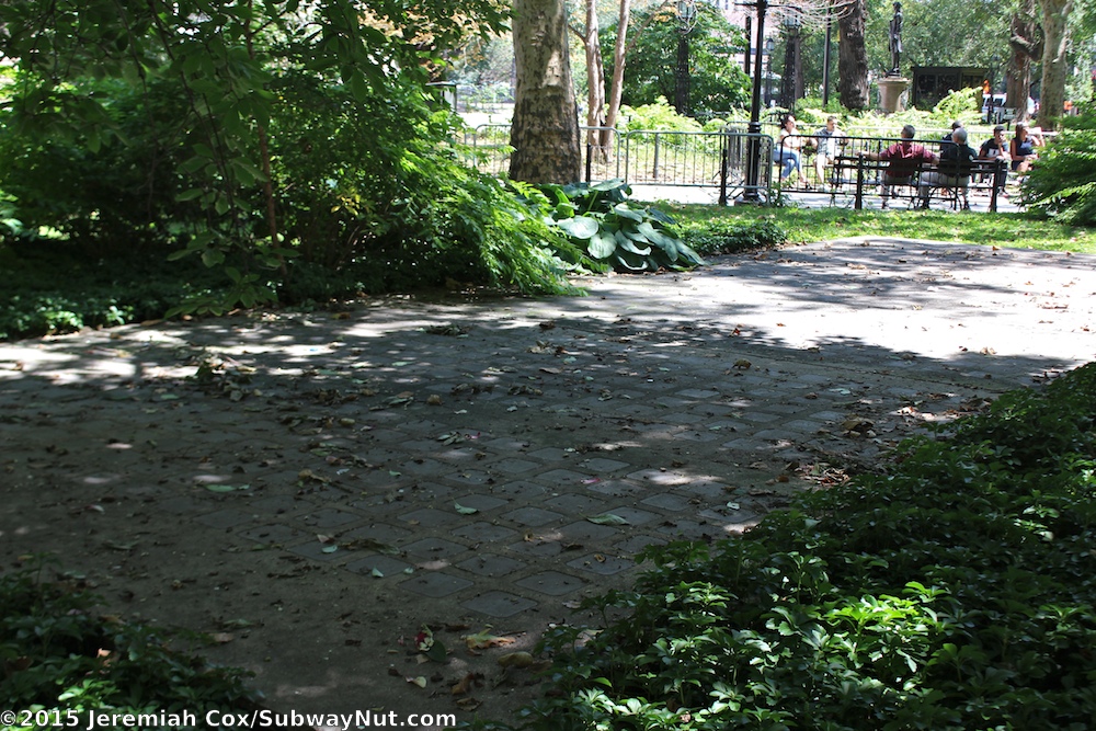
On the surface, all that can be seen is a concrete slab inset with glass tiles, the skylights for the platform below. This patch of concrete is in the middle of a grove of dogwoods in front of City Hall, close to Broadway. However, for the 2004 Centennial Celebration, one of the street entrances was restored (and presently resembles a modern station entrance), and the station was opened for the duration of the celebration. Otherwise, the station is now used only as an emergency exit. As of 2006, tours of the station are once again being conducted,[16] by the staff of the Transit Museum.[17] However, at present, tours are only open to registered members of the museum and require advance payment and reservations.
The station can also be viewed by passengers who stay on the 6 and <6> services as they travel around the loop to head back uptown. Artificial lighting has often been dim to save electricity, but the skylights provide some illumination during the daytime. The loop track is classified as revenue track, and the announcement programs on the R142A subway cars, which were formerly used on the 6 and <6> services, announce a special message reminding passengers that trains would turn around via the loop station.[18] The older R62As, which make up the entire 6 and <6> services' fleet as of 2018, use manual announcements.[19]
A replica of the station was built for the feature film Fantastic Beasts And Where To Find Them. In addition, the station is said to be the model for the lair of Teenage Mutant Ninja Turtles.[14]
Station layout
| G | - | Street Level |
| P Platform level |
Side platform, not in service | |
| Northbound local | ← | |
This station is unusually elegant in architectural style, and is unique among the original IRT stations, employing Romanesque Revival architecture.[20] The travel magazine Travel + Leisure ranked the station 12th in its list of "the most beautiful subway stations in the world" in November 2009.[21][22]
The station was designed by Rafael Guastavino, and makes extensive use of classic Guastavino tile to sheathe its soaring roof arches.[23] The vaults consist of numerous layers of tiles; most of the vaults are composed of white tiles, with green and brown tiles along the perimeter of each ceiling vault.[4]:6 The main consulting architects on the IRT stations were George Lewis Heins and Christopher Grant LaFarge for the company Heins & LaFarge.[24] The platform is made of poured concrete. White, brown, and blue plaques with the station name are inlaid within the brick platform walls.[4]:6
The station consists of a curved five-car-long side platform serving the single balloon loop track.[25][4]:6 Because of the small radius of curvature of the track, there are significant platform gaps between the railcar doors and the platform, requiring the passengers to "mind the gap" whenever a special stop is made at the station.
After construction was complete, this station was the chosen place for hanging commemorative plaques recognizing the achievement of building the entire New York City Subway system.[24] A wide staircase leads to a mezzanine area above the platform, which splits into two narrower staircases to street level.[4]:6 The mezzanine once had an ornamented oak ticket booth, which has since been removed.[24]
Track layout
North of the City Hall station, the IRT Lexington Avenue Line carries four tracks. From west to east, these are the downtown local track, the downtown express track, the uptown express track, and the uptown local track.[25]
South of the Brooklyn Bridge station, there is a switch on the downtown local track, allowing trains to leave service and enter either of two storage tracks. Trains in service turn onto a balloon loop, continuing past the abandoned side platform on the west side of the loop, and re-appearing in the Brooklyn Bridge station on the uptown local track. The uptown and downtown express tracks pass above the loop, continuing south.[25]
a.jpg)
.jpg)
.jpg)
References
- "Our Subway Open: 150,000 Try It; Mayor McClellan Runs the First Official Train". The New York Times. October 28, 1904. p. 1. ISSN 0362-4331. Retrieved April 21, 2020.
- "Historic Station Closed After 41 Years". The New York Times. January 1, 1946. ISSN 0362-4331. Retrieved May 30, 2010.
- "National Register of Historic Places Listings". National Park Service. October 1, 2004. Retrieved March 5, 2009.
- "Interborough Rapid Transit System, Underground Interior" (PDF). New York City Landmarks Preservation Commission. November 24, 1981. Retrieved November 19, 2019.
- "Abandoned Stations : City Hall (IRT)". Columbia.edu. December 31, 1903. Retrieved May 13, 2014.
- James Blaine Walker, Fifty Years of Rapid Transit, 1864-1917, published 1918, pp. 162-191
- "New York City subway opens - Oct 27, 1904". history.com. October 27, 1904. Retrieved October 25, 2015.
- "Subway Opening to-day With Simple Ceremony; Exercises at One o'Clock; Public to be Admitted at Seven". The New York Times. October 27, 1904. ISSN 0362-4331. Retrieved April 19, 2020.
- "Interesting Facts About Our Subway; Chronology of the Great Underground System". The New York Times. October 28, 1904. ISSN 0362-4331. Retrieved April 19, 2020.
- "City Hall Station". The-tech.mit.edu. Retrieved May 13, 2014.
- Map and Profile of Railway (Map). Interborough Rapid Transit Company. 1904. Retrieved September 15, 2008.
- "New York City Subway's "Jewel In The Crown" — The Defunct City Hall Station". Puppies and Flowers. April 22, 2009. Archived from the original on April 15, 2016. Retrieved May 13, 2014.
- Jaffe, Eric (July 18, 2012). "New York's Lovely Abandoned Subway Station". The Atlantic Cities. The Atlantic. Retrieved July 18, 2012.
- Hu, Winnie (April 11, 2019). "Failing New York Subway? Not Always - Once There Were Chandeliers". The New York Times. ISSN 0362-4331. Retrieved April 11, 2019.
- "Old City Hall Station Of IRT to Close Monday". The New York Times. December 27, 1945. ISSN 0362-4331. Retrieved September 4, 2016.
- "Living for the City". Forgotten NY. Retrieved November 15, 2009.
- New York City Transit Museum programs
- Cuza, Bobby (March 6, 2007). "See A Glimpse Of NYC History For The Price Of A Subway Ride". NY1. Archived from the original on January 30, 2013. Retrieved November 15, 2009.
- R62/A and R68/A Request for Information
- Brooks, Michael W. (1997). Subway city: riding the trains, reading New York. New Brunswick, New Jersey: Rutgers University Press. p. 66. ISBN 0-8135-2396-6.
- McCulloch, Adam (November 2009). "World's Most Beautiful Subway Stations". Travel + Leisure. Retrieved January 3, 2012.
- "New York City: City Hall". Travel + Leisure. November 2009. Retrieved January 3, 2012.
- Dunlap, David W. (May 1, 2011). "The City's Curves, on Display or Hidden Away". The New York Times. p. 36.
- "THE OLD CITY HALL STATION « UNTAPPED NEW YORK". Untapped New York. October 4, 2010. Archived from the original on October 4, 2010. Retrieved April 19, 2020.CS1 maint: unfit url (link)
- "Tracks of the New York City Subway". Tracks of the New York City Subway. Retrieved October 9, 2015.
Further reading
- Stookey, Lee (1994). Subway ceramics : a history and iconography of mosaic and bas relief signs and plaques in the New York City subway system. Brattleboro, Vt: L. Stookey. ISBN 978-0-9635486-1-0. OCLC 31901471.
External links
| Wikimedia Commons has media related to City Hall (IRT Lexington Avenue Line). |
| External images | |
|---|---|
- nycsubway.org – IRT East Side Line: City Hall
- Abandoned Stations — City Hall (IRT)
- The IRT First Stations — City Hall
- Forgotten NY — Original 28 – NYC's First 28 Subway Stations
- The Abandoned City Hall Subway Stop Now Visible To Tourists (PHOTOS) at The Huffington Post
- Stair landing from Google Maps Street View
| Government buildings |
|  | |||||
|---|---|---|---|---|---|---|---|
| Non-government buildings |
| ||||||
| Other spaces | |||||||
| Education | |||||||
| Transport |
| ||||||
See also: Manhattan Community Board 1 | |||||||
| Lexington Ave. Line |
|
|---|---|
| |
| Topics |  | |
|---|---|---|
| Lists by county |
| |
| Lists by city | ||
| Other lists | ||
| ||