Chiyoda, Gunma
Chiyoda (千代田町, Chiyoda-machi) is a town located in Gunma Prefecture, Japan. As of February 2015, the town had an estimated population of 11,413, and a population density of 525 persons per km². Its total area is 21.73 km².
Chiyoda 千代田町 | |
|---|---|
Town | |
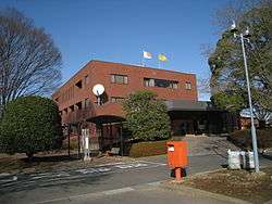 Chiyoda town hall | |
 Flag  Seal | |
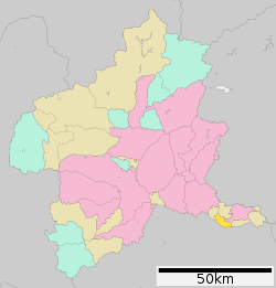 Location of Chiyoda in Gunma Prefecture | |
 Chiyoda | |
| Coordinates: 36°13′3.9″N 139°26′32.7″E | |
| Country | Japan |
| Region | Kantō |
| Prefecture | Gunma Prefecture |
| District | Ōra |
| Area | |
| • Total | 21.73 km2 (8.39 sq mi) |
| Population (February 2015) | |
| • Total | 11,413 |
| • Density | 525/km2 (1,360/sq mi) |
| Time zone | UTC+9 (Japan Standard Time) |
| - Tree | Osmanthus |
| - Flower | Chrysanthemum |
| Phone number | 0276-86-211 |
| Address | Ōaza Akaiwa1895, Chiyoda-machi, Gunma-ken 370-0598 |
| Website | http://www.town.chiyoda.gunma.jp/ |
Geography
Chiyoda is located in the extreme southern corner Gunma prefecture, bordered by Saitama Prefecture to the south.
Surrounding municipalities
- Gunma Prefecture
- Tatebayashi
- Meiwa
- Oizumi
- Ōra
- Saitama Prefecture
- Kumagaya
- Gyōda
- Hanyū
History
The villages of Tominaga, Eiraku, and Nagae were created within Ōra District, Gunma Prefecture on April 1, 1889 with the creation of the municipalities system after the Meiji Restoration. The three villages merged on March 31, 1955 to form the village of Chiyoda. However, the former village of Nagae separated out on September 30, 1956 and became part of Nakashima (today Ōra, Gunma). Chiyoda was raised to town status on April 1, 1982.
Economy
Agriculture remains a mainstay of the local economy; however, Chiyoda has two industrial parks centered on a beer plant operated by Suntory and a chemical plant operated by Marufuku Chemifa.
Education
- Primary Schools
- Nishi Elementary School
- Higashi Elementary School
- Middle Schools
- Chiyoda Middle School
- Libraries
- Yamaya Memorial Library
Transportation
Chiyoda is not served by any railway lines, nor by any national highways.
External links
![]()
- Official Website (in Japanese)
Maebashi (capital) | ||
| Core cities |
| |
| Special cities | ||
| Cities | ||
| Districts | ||
| Authority control |
|
|---|