Cheetham, Manchester
Cheetham[1] is an inner city area and electoral ward of Manchester, England, which in 2011 had a population of 22,562.[2] It lies on the west bank of the River Irk, 1.4 miles (2.3 km) north of Manchester city centre close to the boundary with Salford, bounded by Broughton to the north, Harpurhey to the east, and Piccadilly and Deansgate to the south.
Cheetham Hill
| |
|---|---|
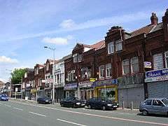 Cheetham Hill Road | |
 Cheetham Hill Location within Greater Manchester | |
| Population | 22,562 (2011 Census) |
| OS grid reference | SD846009 |
| • London | 164 mi (264 km) SE |
| Metropolitan borough | |
| Metropolitan county | |
| Region | |
| Country | England |
| Sovereign state | United Kingdom |
| Post town | MANCHESTER |
| Postcode district | M8 |
| Dialling code | 0161 |
| Police | Greater Manchester |
| Fire | Greater Manchester |
| Ambulance | North West |
| UK Parliament | |
| Councillors |
|
Historically part of Lancashire, Cheetham was a township in the parish of Manchester and hundred of Salford. The township was amalgamated into the Borough of Manchester in 1838, and in 1896 became part of the North Manchester township.[3][4]
Cheetham is home to a multi-ethnic community, a result of several waves of immigration to Britain.[5] In the mid-19th century, it attracted Irish people fleeing the Great Famine. It is now home to the Irish World Heritage Centre.[6] Jews settled in the late-19th and early-20th centuries, fleeing persecution in continental Europe. Migrants from the Indian subcontinent and Caribbean settled in the 1950s and 1960s, and more recently people from Africa, Eastern Europe and the Far East.[5]
Heavily urbanised following the Industrial Revolution, Cheetham is bisected by Cheetham Hill Road, which is lined with churches, mosques, synagogues and temples, as well as terraced houses dating from its history as a textile processing district. Joseph Holt's Brewery is on Empire Street, Cheetham. Markets along the road trade in wares and foodstuffs from all over the world.[5] The Museum of Transport in Manchester in Boyle Street, Cheetham Hill, is part of Queen's Road bus depot.
History
Neolithic implements have been discovered at Cheetham Hill, implying human habitation 7–10,000 years ago.[7]
Unmentioned in the Domesday Book of 1086, Cheetham does not appear in records until 1212, when it was documented to have been a thegnage estate comprising "a plough-land", with an annual rate of 1 mark payable by the tenant, Roger de Middleton, to King John of England.[7] From the Middletons the estate of Cheetham passed to other families, including the Chethams and Pilkingtons.[7]
By the early 20th century, the southern end of Cheetham had a large Jewish population, and nine synagogues.[7] Michael Marks was a Jewish immigrant who lived in Cheetham Hill with his family. He and Thomas Spencer opened the first Marks and Spencer store on Cheetham Hill Road in 1893.[8] The business grew considerably over following years and in 1901 the company's first headquarters was built on Derby Street.[9]
During the Madchester phase of the history of Manchester, narcotic trade in the city became "extremely lucrative" and in the early 1980s a gang war started between two groups vying for control of the market in Manchester city centre - the Cheetham Hill Gang and The Gooch Close Gang, in Cheetham Hill and Moss Side respectively.[10]
Governance
Lying within the historic county boundaries of Lancashire since the early 12th century, Cheetham anciently constituted a thegnage estate, held by tenants who paid tax to the King.[7] Cheetham during the Middle Ages formed a township in the parish of Manchester, and hundred of Salford.[7] Governance continued on this basis until the Industrial Revolution, when Cheetham and the neighbouring Manchester Township had become suffiently urbanised and integrated to warrant an amalgamation into a single district: the then Borough of Manchester, in 1838.[3] There was a Cheetham Committee of Manchester Borough Council until 1875. Cheetham continued to hold the status of a township until 1896, when, together with Beswick, Blackley, Bradford, Clayton, Crumpsall, Harpurhey, Moston and Newton, it became part of the township of North Manchester.[3][4] North Manchester was a part of the City and County Borough of Manchester.
Following the Poor Law Amendment Act 1834, Cheetham formed part of the Manchester Poor Law Union from 1841 to 1850, Prestwich Poor Law Union from 1850 to 1915, and returned to Manchester Poor Law Union in 1915 until 1930. These were inter-parish units established to provide social security.[3]
_2018.png)
Cheetham is an electoral ward of Manchester City Council,[11] and is part of the Blackley and Broughton parliamentary constituency. Blackley and Broughton is a new constituency created in 2010, replacing the former Manchester Blackley constituency, of which the Cheetham Hill area was also included in. The current MP is Graham Stringer of the Labour Party, first representing Manchester Blackley since 1997 and now Blackley and Broughton. Winston Churchill was Liberal MP for the area early in his political career (some years before he re-crossed the floor to the Conservative Party).
Councillors
Three councillors serve the ward: Julie Connolly (Lab),[12] Shaukat Ali (Lab),[13] and Naeem Hassam (Lab).[14]
| Election | Councillor | Councillor | Councillor | |||
|---|---|---|---|---|---|---|
| 2004 | Naeem Hassam (Lab) | Afzal Khan (Lab) | Martin Pagel (Lab) | |||
| 2006 | Naeem Hassam (Lab) | Afzal Khan (Lab) | Martin Pagel (Lab) | |||
| 2007 | Naeem Hassam (Lab) | Afzal Khan (Lab) | Martin Pagel (Lab) | |||
| 2008 | Naeem Hassam (Lab) | Afzal Khan (Lab) | Martin Pagel (Lab) | |||
| 2010 | Naeem Hassam (Lab) | Afzal Khan (Lab) | Martin Pagel (Lab) | |||
| 2011 | Naeem Hassam (Lab) | Afzal Khan (Lab) | Martin Pagel (Lab) | |||
| 2012 | Naeem Hassam (Lab) | Afzal Khan (Lab) | Shaukat Ali (Lab) | |||
| 2014 | Naeem Hassam (Lab) | Afzal Khan (Lab) | Shaukat Ali (Lab) | |||
| 2015 | Naeem Hassam (Lab) | Julie Connolly (Lab) | Shaukat Ali (Lab) | |||
| 2016 | Naeem Hassam (Lab) | Julie Connolly (Lab) | Shaukat Ali (Lab) | |||
| 2018 | Naeem Hassam (Lab) | Julie Connolly (Lab) | Shaukat Ali (Lab) | |||
| 2019 | Naeem Hassam (Lab) | Shazia Butt (Lab) | Shaukat Ali (Lab) | |||
indicates seat up for re-election.
Geography
At 53°30′14″N 2°13′51″W (53.504°, -2.231°), Cheetham is 1.4 miles (2.3 km) northeast of Manchester city centre. To the north, it is bordered by Crumpsall, to the west by Broughton in Salford, to the east and the southeast by Harpurhey and Collyhurst, and by Manchester City Centre to the south.
Cheetham Hill lies on "rising ground"[15] and is completely urbanised.[7]
Neighbouring districts and places. | |
|---|---|
Demography
| Cheetham ward compared[16] | |||
|---|---|---|---|
| 2011 UK census | Cheetham | City of Manchester | England |
| Total population | 22,562 | 503,127 | 53,012,456 |
| White British | 28.6% | 59.3% | 79.8% |
| White Irish | 1.6% | 2.5% | 1.1% |
| White other | 7.0% | 4.9% | 4.6% |
| Asian | 38.8% | 14.4% | 7% |
| Black | 10.6% | 8.6% | 3.4% |
| Chinese | 3.0% | 2.7% | 0.7% |
| Mixed | 4.8% | 4.7% | 2.2% |
| Arab or other | 4.6% | 3.1% | 1% |
The ward had a population of 22,562 at the 2011 census.[17] Its population accounted for 4.2% of the city of Manchester's in 2010.[18] In November 2011, 68.5% of residential properties were classified as private, while 31.5% were classified as social housing.[18] House prices remain below the Manchester average.[18]
Notable people
- Don Arden — music promoter and manager of the Small Faces, ELO (born Harry Levy), father of Sharon Osbourne was born in Cheetham Hill
- Frances Hodgson Burnett — writer of The Secret Garden and A Little Princess was born in Cheetham Hill
- Sandra Douglas — athlete, a member of the Olympic 4 x 400 metre bronze medal winning team in Barcelona 1992
- Jessie Fothergill (1851–1891), novelist, was born in Cheetham Hill[19]
- Abraham Hyman — survivor of the Titanic liner disaster, opened a delicatessen in Cheetham Hill, where it remains to this day[20]
- Howard Jacobson — author, was born and raised in Cheetham Hill
- George Augustus Lee (1761–1826), industrialist, lived in Cheetham Hill
- Lois Maynard — footballer for FC Halifax Town.
- Jack Rosenthal — playwright, known for The Evacuees, Bar Mitzvah Boy and early episodes of Coronation Street
- Benny Rothman — political activist, famous for taking part in the Mass trespass of Kinder Scout in Derbyshire
- J. J. Thomson — English physicist who discovered the electron and won the Nobel Prize was born in Cheetham Hill
- Bugzy Malone ; Grime Artist
See also
References
- The Ordnance Survey records the placename as "Cheetham Hill". See: SD8464900950
- "City of Manchester Ward population 2011". Retrieved 4 January 2015.
- "Greater Manchester Gazetteer". Greater Manchester County Record Office. Places names - C. Archived from the original on 18 July 2011. Retrieved 17 October 2008.
- Great Britain Historical GIS Project (2004). "North Manchester CP through time. Census tables with data for the Parish-level Unit". A vision of Britain through time. University of Portsmouth. Retrieved 2 November 2008.CS1 maint: ref=harv (link)
- "North Wards; Cheetham Hill" (PDF). northwards.net. December 2004. p. 9. Archived from the original (PDF) on 27 March 2009.
- "Irish World Heritage Centre". Irish World Heritage Centre.
- Brownbill 1911, pp. 259–262.
- "Cheetham Hill". Manchester City Council. Archived from the original on 3 October 2006. Retrieved 10 March 2011.
- "Marks and Spencer's Yorkshire roots". Genealogist. Retrieved 10 March 2011.
- "A street guide to gangs in Manchester". bbc.co.uk. 6 January 2003. Retrieved 14 November 2008.
- United Kingdom Census 2001 (2001). "Cheetham (Ward)". neighbourhood.statistics.gov.uk. Retrieved 13 November 2008.
- "Julie Connolly". manchester.gov.uk. Manchester City Council. Retrieved 16 May 2018.
- "Shaukat Ali". manchester.gov.uk. Manchester City Council. Retrieved 16 May 2018.
- "Naeem Hassam". manchester.gov.uk. Manchester City Council. Retrieved 16 May 2018.
- Lewis 1848, pp. 562–569.
- "Cheetham (ward): Ethnic group, 2011". Office for National Statistics. Retrieved 3 September 2014.
- "2011 Census Cheetham dashboard". Manchester City Council. Retrieved 23 July 2014.
- "Cheetham ward profile". Manchester City Council. Archived from the original on 2 December 2013. Retrieved 26 November 2013.
- Oxford Dictionary of National Biography Retrieved on 24 September 2008
- "About Titanics ltd". Archived from the original on 28 November 2007. Retrieved 15 December 2007.
| Wikimedia Commons has media related to Cheetham Hill. |