Charlestown, Maryland
Charlestown is a town in Cecil County, Maryland, United States. The population was 1,183 at the 2010 census.
Charlestown, Maryland | |
|---|---|
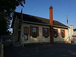 Town hall and post office | |
 Seal | |
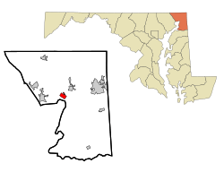 Location of Charlestown, Maryland | |
| Coordinates: 39°34′36″N 75°58′40″W | |
| Country | |
| State | |
| County | |
| Incorporated | 1742[1] |
| Government | |
| • President | Joseph Letts |
| Area | |
| • Total | 1.17 sq mi (3.03 km2) |
| • Land | 1.17 sq mi (3.03 km2) |
| • Water | 0.00 sq mi (0.01 km2) |
| Elevation | 36 ft (11 m) |
| Population | |
| • Total | 1,183 |
| • Estimate (2019)[4] | 1,196 |
| • Density | 1,023.10/sq mi (395.11/km2) |
| Time zone | UTC-5 (Eastern (EST)) |
| • Summer (DST) | UTC-4 (EDT) |
| ZIP code | 21914 |
| Area code(s) | 410 |
| FIPS code | 24-15400 |
| GNIS feature ID | 0589939 |
| Website | http://www.charlestownmd.org/ |
History
Charlestown is the location of Charlestown Historic District and Indian Queen Tavern and Black's Store, both listed on the National Register of Historic Places in 1975.[5]
Geography
Charlestown is located at 39°34′36″N 75°58′40″W (39.576617, -75.977888).[6]
According to the United States Census Bureau, the town has a total area of 1.51 square miles (3.91 km2), of which, 1.19 square miles (3.08 km2) is land and 0.32 square miles (0.83 km2) is water.[7]
Demographics
| Historical population | |||
|---|---|---|---|
| Census | Pop. | %± | |
| 1870 | 223 | — | |
| 1880 | 211 | −5.4% | |
| 1890 | 228 | 8.1% | |
| 1900 | 244 | 7.0% | |
| 1910 | 274 | 12.3% | |
| 1920 | 177 | −35.4% | |
| 1930 | 286 | 61.6% | |
| 1940 | 307 | 7.3% | |
| 1950 | 551 | 79.5% | |
| 1960 | 711 | 29.0% | |
| 1970 | 721 | 1.4% | |
| 1980 | 720 | −0.1% | |
| 1990 | 578 | −19.7% | |
| 2000 | 1,019 | 76.3% | |
| 2010 | 1,183 | 16.1% | |
| Est. 2019 | 1,196 | [4] | 1.1% |
| U.S. Decennial Census[8] | |||
2010 census
As of the census[3] of 2010, there were 1,183 people, 454 households, and 324 families living in the town. The population density was 994.1 inhabitants per square mile (383.8/km2). There were 550 housing units at an average density of 462.2 per square mile (178.5/km2). The racial makeup of the town was 94.8% White, 3.7% African American, 0.2% Native American, 0.1% Asian, 0.2% from other races, and 1.1% from two or more races. Hispanic or Latino of any race were 2.5% of the population.
There were 454 households, of which 31.9% had children under the age of 18 living with them, 54.8% were married couples living together, 9.0% had a female householder with no husband present, 7.5% had a male householder with no wife present, and 28.6% were non-families. 23.3% of all households were made up of individuals, and 7.9% had someone living alone who was 65 years of age or older. The average household size was 2.60 and the average family size was 3.05.
The median age in the town was 41.4 years. 22.5% of residents were under the age of 18; 7.5% were between the ages of 18 and 24; 26.1% were from 25 to 44; 32.9% were from 45 to 64; and 11% were 65 years of age or older. The gender makeup of the town was 50.3% male and 49.7% female.
2000 census
As of the census[9] of 2000, there were 1,019 people, 386 households, and 282 families living in the town. The population density was 1,124.8 people per square mile (432.3/km2). There were 451 housing units at an average density of 497.8 per square mile (191.4/km2). The racial makeup of the town was 97.94% White, 1.77% African American, 0.10% Native American, and 0.20% from two or more races. Hispanic or Latino of any race were 0.29% of the population.
In 2000, 26.7% of Charlestown residents identified as being of Irish American heritage. This was the highest percentage of Irish Americans of any place in Maryland.[10]
There were 386 households, out of which 35.8% had children under the age of 18 living with them, 58.8% were married couples living together, 9.1% had a female householder with no husband present, and 26.7% were non-families. 17.6% of all households were made up of individuals, and 7.3% had someone living alone who was 65 years of age or older. The average household size was 2.64 and the average family size was 3.03.
In the town, the population was spread out, with 26.8% under the age of 18, 5.9% from 18 to 24, 34.6% from 25 to 44, 22.3% from 45 to 64, and 10.4% who were 65 years of age or older. The median age was 36 years. For every 100 females, there were 110.5 males. For every 100 females age 18 and over, there were 107.2 males.
The median income for a household in the town was $50,563, and the median income for a family was $57,644. Males had a median income of $40,104 versus $25,978 for females. The per capita income for the town was $20,959. About 3.2% of families and 5.1% of the population were below the poverty line, including 6.5% of those under age 18 and 4.7% of those age 65 or over.
Education
Charlestown is within Cecil County Public Schools. Zoned public schools include Charlestown Elementary School, Perryville Middle School, and Perryville High School.[11]
Gallery
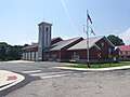 Fire station
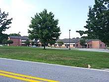
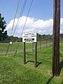 Athletic complex
References
- "Charlestown". Maryland Manual. Retrieved 25 June 2017.
- "2019 U.S. Gazetteer Files". United States Census Bureau. Retrieved July 25, 2020.
- "U.S. Census website". United States Census Bureau. Retrieved 2013-01-25.
- "Population and Housing Unit Estimates". United States Census Bureau. May 24, 2020. Retrieved May 27, 2020.
- "National Register Information System". National Register of Historic Places. National Park Service. April 15, 2008.
- "US Gazetteer files: 2010, 2000, and 1990". United States Census Bureau. 2011-02-12. Retrieved 2011-04-23.
- "US Gazetteer files 2010". United States Census Bureau. Archived from the original on 2012-01-25. Retrieved 2013-01-25.
- "Census of Population and Housing". Census.gov. Retrieved June 4, 2015.
- "U.S. Census website". United States Census Bureau. Retrieved 2008-01-31.
- "Ancestry Map of Irish Communities". Epodunk.com. Retrieved 2015-04-16.
- "Archived copy". Archived from the original on 2003-12-18. Retrieved 2003-12-18.CS1 maint: archived copy as title (link)
External links
| Wikimedia Commons has media related to Charlestown, Maryland. |
Municipalities and communities of Cecil County, Maryland, United States | ||
|---|---|---|
| Towns | 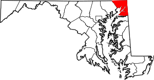 | |
| Unincorporated communities |
| |
| Ghost town | ||
| Authority control |
|---|