Cantrall, Illinois
Cantrall is a village in Sangamon County, Illinois, United States. The population was 139 at the 2000 census. It is part of the Springfield, Illinois Metropolitan Statistical Area.
Cantrall | |
|---|---|
Village | |
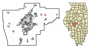 Location of Cantrall in Sangamon County, Illinois. | |
.svg.png) Location of Illinois in the United States | |
| Coordinates: 39°56′13″N 89°40′36″W | |
| Country | United States |
| State | Illinois |
| County | Sangamon |
| Area | |
| • Total | 0.25 sq mi (0.65 km2) |
| • Land | 0.25 sq mi (0.65 km2) |
| • Water | 0.00 sq mi (0.00 km2) |
| Elevation | 591 ft (180 m) |
| Population (2010) | |
| • Total | 139 |
| • Estimate (2019)[2] | 133 |
| • Density | 532.00/sq mi (205.25/km2) |
| Time zone | UTC−6 (CST) |
| • Summer (DST) | UTC−5 (CDT) |
| Area code(s) | 217 |
| FIPS code | 17-11033 |
| Wikimedia Commons | Cantrall, Illinois |
Geography
Cantrall is located at 39°56′13″N 89°40′36″W (39.936969, -89.676634).[3]
According to the 2010 census, Cantrall has a total area of 0.26 square miles (0.67 km2), all land.[4]
Demographics
| Historical population | |||
|---|---|---|---|
| Census | Pop. | %± | |
| 1900 | 396 | — | |
| 1910 | 318 | −19.7% | |
| 1920 | 187 | −41.2% | |
| 1930 | 170 | −9.1% | |
| 1940 | 179 | 5.3% | |
| 1950 | 145 | −19.0% | |
| 1960 | 115 | −20.7% | |
| 1970 | 138 | 20.0% | |
| 1980 | 141 | 2.2% | |
| 1990 | 123 | −12.8% | |
| 2000 | 139 | 13.0% | |
| 2010 | 139 | 0.0% | |
| Est. 2019 | 133 | [2] | −4.3% |
| U.S. Decennial Census[5] | |||
As of the census[6] of 2000, there were 139 people, 53 households, and 40 families residing in the village. The population density was 545.3 people per square mile (214.7/km2). There were 55 housing units at an average density of 215.8 per square mile (84.9/km2). The racial makeup of the village was 99.28% White, and 0.72% Asian.
There were 53 households out of which 43.4% had children under the age of 18 living with them, 66.0% were married couples living together, 3.8% had a female householder with no husband present, and 24.5% were non-families. 22.6% of all households were made up of individuals and 11.3% had someone living alone who was 65 years of age or older. The average household size was 2.62 and the average family size was 3.08.
In the village, the age distribution of the population shows 25.2% under the age of 18, 5.8% from 18 to 24, 30.9% from 25 to 44, 20.1% from 45 to 64, and 18.0% who were 65 years of age or older. The median age was 40 years. For every 100 females, there were 113.8 males. For every 100 females age 18 and over, there were 100.0 males.
The median income for a household in the village was $45,000, and the median income for a family was $45,417. Males had a median income of $49,375 versus $21,719 for females. The per capita income for the village was $21,610. There were none of the families and 1.4% of the population living below the poverty line, including no under eighteens and none of those over 64.
Local attractions
The Sangamon River State Fish and Wildlife Area is located 4.5 miles (7.2 km) southwest of Cantrall, on the banks of the Sangamon River.
Notable person
- Carl Vandagrift, infielder for the Indianapolis Hoosiers; born in Cantrall
References
- "2019 U.S. Gazetteer Files". United States Census Bureau. Retrieved July 14, 2020.
- "Population and Housing Unit Estimates". United States Census Bureau. May 24, 2020. Retrieved May 27, 2020.
- "US Gazetteer files: 2010, 2000, and 1990". United States Census Bureau. 2011-02-12. Retrieved 2011-04-23.
- "G001 - Geographic Identifiers - 2010 Census Summary File 1". United States Census Bureau. Archived from the original on 2020-02-13. Retrieved 2015-08-02.
- "Census of Population and Housing". Census.gov. Retrieved June 4, 2015.
- "U.S. Census website". United States Census Bureau. Retrieved 2008-01-31.
Municipalities and communities of Sangamon County, Illinois, United States | ||
|---|---|---|
| Cities | Map of Illinois highlighting Sangamon County | |
| Villages | ||
| Townships | ||
| Unincorporated communities | ||
| Footnotes | ‡This city also has portions in adjacent county or counties | |