Boxford, Berkshire
Boxford is a village and civil parish in the unitary authority of West Berkshire, part of Berkshire in England.
| Boxford | |
|---|---|
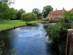 Watermill at the centre of the village | |
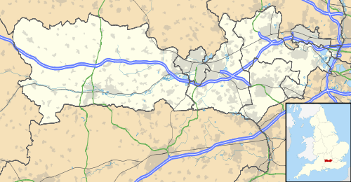 Boxford Location within Berkshire | |
| Area | 11.74 km2 (4.53 sq mi) |
| Population | 463 (2011 census)[1] |
| • Density | 39/km2 (100/sq mi) |
| OS grid reference | SU428715 |
| Civil parish |
|
| Unitary authority | |
| Ceremonial county | |
| Region | |
| Country | England |
| Sovereign state | United Kingdom |
| Post town | Newbury |
| Postcode district | RG20 |
| Dialling code | 01488 |
| Police | Thames Valley |
| Fire | Royal Berkshire |
| Ambulance | South Central |
| UK Parliament | |
| Website | Boxford Royal County of Berkshire |
The village is on the east bank of the Lambourn, about 4 miles (6.4 km) northwest of Newbury but south of the M4 motorway. The included hamlet of Westbrook is on the opposite bank of the Berkshire Downs tributary.
Archaeology
A number of Bronze Age features have been recorded near Boxford and an urn of this period has been found.[2]
A hearth and pottery fragments from the Iron Age, including a La Tène pot, have been found near the north end of Boxford Common.[3] Iron Age pottery fragments and a possible earthwork have also been found near Borough Hill.[4]
Mud Hall Cottage on Wyfield Farm is the site of a large Roman building which was excavated about 1870.[5] Roman pottery and coins have been found at Boxford Rectory.[6] The course of Ermin Street Roman road that linked Corinium Dobunnorum (Cirencester) and Calleva Atrebatum (Silchester) passes through the south of the parish. A 140-yard (130 m) section is visible from aerial archaeology near William's Copse.[7]
A large Roman mosaic, perhaps 10 metres square, was found in 2017. It was on the floor of a villa dating from the 4th century AD.[8]
Manor
In AD 958 King Eadred granted property at Boxore to his servant Wulfric, and in 968 King Edgar the Peaceful granted a similar amount of property here to his servant Elfwin.[9] Both men ceded their holdings to Abingdon Abbey, which thus held the whole manor of Boxford before the Norman Conquest of England.[9]
Domesday Book of 1086 records Boxford as Bochesorne. It says under the list of lands that belonged to Abingdon Abbey:
Of the land in this manor, Reinbold holds Leckhampstead 10 hides and William 4 hides at Weston and Berner 2 hides at Boxford... There is land for 11 ploughs. There are three ploughs and 12 villans and 24 bordars with six ploughs and six four slaves and two acres of meadow and a church. It is and was worth 10 pounds.[10]
Boxford House is a Grade II listed country house which is believed to date from 1825.[11] It is built of ashlar masonry in a Gothic revival style, with mullioned and transomed windows. It has a slate roof and a parapet.[12]
Parish church
The Church of England parish church of Saint Andrew consists of a chancel, nave, north aisle, north-west vestry, south porch and a west tower. The chancel may be Saxon, and a Saxon window was discovered in a wall of the church in 2011.[13] The Jacobean pulpit dates from 1618,[14] the font from about 1662[14] and the west tower from about 1692.[15]
Much of the church was rebuilt in the Victorian era and in 1841 the north aisle was added.[15] However, the arcade between the nave and north aisle was probably by John Oldrid Scott and Sons in 1908.[15] The building is Grade II* listed.[16]
Social and economic history
The village has a number of thatched cottages and a watermill.[17]
Boxford railway station was opened by the Lambourn Valley Railway in 1898 and closed by British Railways in 1960.
Boxford is known for the Boxford Masques, an outdoor midsummer celebration held on Hoar Hill in woodland above the village overlooking the Lambourn valley. It was originally created in the late 19th century by Charlotte Peake, a local writer and lover of music, drama and poetry. The Boxford Masques was performed by locals and lasted only up until the First World War. It was revived in the year 2000 by the Watermill Theatre of Bagnor, near Newbury, following extensive research by Mr John Vigor; it has been very popular since. The 2012 production was performed at the nearby Welford House and bore the name A Little Drama at the Big House, telling the story of the founding of the plays, based on fact and re-imagined by Geraldine McCaughrean.
Geography
Boxford has several sites of Special Scientific Interest (SSSI), namely Easton Farm Meadow, Boxford Chalk Pit and Boxford Water Meadows.[18][19][20]
Demography
| Output area | Homes owned outright | Owned with a loan | Socially rented | Privately rented | Other | km² roads | km² water | km² domestic gardens | Usual residents | km² |
|---|---|---|---|---|---|---|---|---|---|---|
| Civil parish | 76 | 65 | 20 | 26 | 5 | 0.163 | 0.057 | 0.234 | 463 | 11.74 |
References
- Key Statistics: Dwellings; Quick Statistics: Population Density; Physical Environment: Land Use Survey 2005
- "National Monuments Record".
- "National Monuments Record (Monument No. 233551)".
- "National Monuments Record (Monument No. 233581)".
- "National Monuments Record (Monument No. 233554)".
- "National Monuments Record (Monument No. 233557)".
- "National Monuments Record (Monument No. 1307472)".
- Evans, Martin (3 September 2017). "'Most exciting Roman mosaic for 50-years' is discovered during community dig in Berkshire". Daily Telegraph. Retrieved 8 September 2017.
- Page & Ditchfield, 1924, pages 44–48
- Domesday Book: A Complete Translation. London: Penguin Books. 2003. p. 142. ISBN 0-14-143994-7.
- Historic England. "Boxford House (Grade II) (1219875)". National Heritage List for England. Retrieved 8 September 2017.
- Ford, David Nash. "Boxford House". Royal Berkshire History.
- "Saxon window sheds light on Boxford's past". Diocese of Oxford. Archived from the original on 22 July 2011. Retrieved 1 April 2011.
- Pevsner, 1966, page 93
- Pevsner, 1966, page 92
- Historic England. "Parish Church of St. Andrew (Grade II*) (1219764)". National Heritage List for England. Retrieved 8 September 2017.
- Historic England. "Boxford Mill (Grade II) (1219880)". National Heritage List for England. Retrieved 8 September 2017.
- "Magic Map Application". Magic.defra.gov.uk. Retrieved 8 March 2017.
- "Magic Map Application". Magic.defra.gov.uk. Retrieved 19 March 2017.
- "Magic Map Application". Magic.defra.gov.uk. Retrieved 19 March 2017.
Sources
- Page, W.H.; Ditchfield, P.H., eds. (1924). A History of the County of Berkshire, Volume 4. Victoria County History. pp. 44–48.
- Pevsner, Nikolaus (1966). Berkshire. The Buildings of England. Harmondsworth: Penguin Books. pp. 92–93.
External links
![]()