Bishopsgate
Bishopsgate is one of the 25 wards in the City of London financial district. It is also the name of a stretch of the originally Roman Ermine Street (now the A10) between Gracechurch Street and Norton Folgate.[2] Bishopsgate is named after one of the original eight gates in the London Wall. The ward is traditionally divided into Bishopsgate Within, inside the line of the City's former walls, and Bishopsgate Without beyond them. Bishopsgate Without is described as part of London's East End.[3]
| Ward of Bishopsgate | |
|---|---|
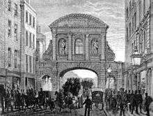
 A circa 1650 print of the gate | |
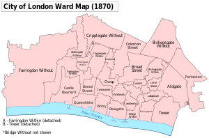
 Bishopsgate ward within the City - after the boundary changes of 1994 and 2003 | |
 Ward of Bishopsgate Location within Greater London | |
| Population | 222 (2011 Census Ward)[1] |
| OS grid reference | TQ330813 |
| Sui generis | |
| Administrative area | Greater London |
| Region | |
| Country | England |
| Sovereign state | United Kingdom |
| Post town | LONDON |
| Postcode district | EC2 |
| Dialling code | 020 |
| Police | City of London |
| Fire | London |
| Ambulance | London |
| UK Parliament | |
| London Assembly | |
Although tens of thousands of people commute to and work in the ward, it has a resident population of only 222 (2011).[4]
The Gate
Originally Roman, the Bishop's Gate was rebuilt by the Hansa merchants in 1471 in exchange for Steelyard privileges. Its final form was erected in 1735 by the City authorities and demolished in 1760. This gate often displayed the heads of criminals on spikes. London Wall (which is no longer extant in this sector) divided the ward and road into an intramural portion called Bishopsgate Within and an extramural portion called Bishopsgate Without. The site of this former gate is marked by a stone bishop's mitre, fixed high upon a building located at Bishopsgate's junction with Wormwood Street, by the gardens there and facing the Heron Tower.
Wards and parishes
Bishopsgate is one of 25 wards in the City of London, each electing an Alderman to the Court of Aldermen, and Commoners (the City equivalent of a councillor) to the Court of Common Council of the City of London Corporation. Only electors who are Freemen of the City of London are eligible to stand.
Ward
The ward (which is large by City standards) is bounded by Worship Street to the north, where the edge of the City meets the boroughs of Islington and Hackney. It neighbours Portsoken ward and the borough of Tower Hamlets in the east. The western boundary is formed by Old Broad Street and Broad Street ward itself. Bishopsgate also bounds the wards of Aldgate (southeast), Coleman Street (west), Cornhill (southwest) and Lime Street (south). Bishopsgate ward straddles the (now former) line of the Wall and the old gate and is often (even today)[5] divided into "Within" and "Without" parts, with a deputy (alderman) appointed for each part.
Ward boundary changes
Since the 1994 (City) and 2003 (ward) boundary changes, almost all of the ward is Without; only a small area surrounding the Leathersellers' livery hall remains as Bishopsgate Within.[6] The ward previously extended much further south, along the Bishopsgate road and Gracechurch Street to meet Langbourn ward, but in the 2003 changes much of the Within part was transferred to Cornhill and Lime Street. No changes to Bishopsgate's ward boundaries occurred in the 2013 boundary changes.[6] Bishopsgate Without gained a large area from the Shoreditch area of the London Borough of Hackney,[7] and lost a small block of buildings east Blomfield Street to the Broad Street ward.
Parishes
Bishopsgate Within was originally divided into many parishes, each with its own parish church: St Andrew Undershaft, St Ethelburga Bishopsgate, St Martin Outwich, St Mary Axe and St Helen's Bishopsgate, now all amalgamated under the last of these. St Helen's is a very historic medieval church and former monastic establishment with many ancient funerary monuments and a stained glass window depicting William Shakespeare — commemorating a very famous former parishioner who lived in the area in the early to mid 1590s.
Bishopsgate Without corresponds to the parish of St Botolph-without-Bishopsgate. The parish church for the area of Bishopsgate Without is St Botolph-without-Bishopsgate. This is located immediately north of the site of the original Gate on the west side of the road.


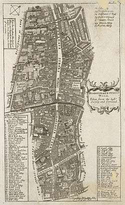
The Street
The Bishopsgate thoroughfare forms part of the A10 and the section to the north of the site of the original Gate is the start of Roman Ermine Street, also known as the 'Old North Road'. The street is home to the main London offices of several major banks, including National Westminster Bank and the European Bank for Reconstruction and Development. Within the ward falls Liverpool Street station and the Broadgate Estate.
Skyscrapers and other notable buildings

The following are notable buildings, tall buildings and skyscrapers built, under construction or approved for Bishopsgate Ward, from north to south:
- Broadgate Tower
- Heron Tower
- 99 Bishopsgate
- 100 Bishopsgate (under construction)
- Tower 42
- 22 Bishopsgate (under construction)
- Liverpool Street station
- Bishopsgate Institute
History
Bishopsgate was originally the location of many coaching inns which accommodated passengers setting out on the Old North Road. These, though they survived the Great Fire of London, have now all been demolished. These included the Angel, the Black Bull, the Dolphin, the Flower Pot, the Green Dragon, the Magpie and Punchbowl, the White Hart and the Wrestlers. The Black Bull was a venue for the Queen's Men theatrical troupe in the 16th century.
The name of an inn called the Catherine Wheel (demolished 1911) is commemorated by Catherine Wheel Alley which leads off Bishopsgate to the east. The 17th century facade of Sir Paul Pindar's House, demolished to make way for Liverpool Street railway station in 1890, on Bishopsgate was also preserved and can now be seen in the Victoria and Albert Museum. In the 18th century this grand residence became a tavern called Sir Paul Pindar's Head; another notable venue was the London Tavern (1768-1876). Also demolished (but then re-erected in Chelsea) was the old Crosby Hall, at one time the residence of Richard III and Thomas More.

Bishopsgate is also the site of Dirty Dick's (a pub over 200 years old), the Bishopsgate Institute, and many offices and skyscrapers.
On 24 April 1993 it was the site of an IRA truck bombing which killed journalist Ed Henty, injured over 40 people and caused £1 billion worth of damage,[8] including the destruction of St Ethelburga's church and damage to the NatWest Tower and Liverpool Street station. Police had received a coded warning, but were still evacuating the area at the time of the explosion. The area had already suffered damage from the Baltic Exchange bombing one year before.
Gallery
 Bishopsgate and the extramural part of Bishopsgate Street, as shown on the "Copperplate" map of London of the 1550s
 The bishop's mitre at Bishopsgate's junction with Wormwood Street
 A former London Fire Brigade station on Bishopsgate (designed by Robert Pearsall), now a supermarket
 The southernmost portion of Bishopsgate pictured in 1955, looking north toward the National Provincial Bank
 Bas relief on the former National Provincial Bank
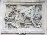 From the same building
 Overview of another part of the building
See also
References
- "City of London ward population 2011". Neighbourhood Statistics. Office for National Statistics. Archived from the original on 8 April 2017. Retrieved 16 October 2016.
- The City of London-a history Borer, M.I.C. : New York, D.McKay Co, 1978 ISBN 0-09-461880-1.
- Beyond the Tower: a history of East London. by John Marriot. In it refers back to 18th century descriptions of Bishopsgate Without and Shoreditch as EE districts
- "Local statistics - Office for National Statistics". www.neighbourhood.statistics.gov.uk.
- Wardmote minutes 2010 Archived 9 March 2012 at the Wayback Machine – see page 9
- City of London Corporation Archived 12 June 2011 at the Wayback Machine Ward boundary review 2010 (final recommendations) – see page 15
- The legislation transferring additional areas to the City of London http://www.legislation.gov.uk/uksi/1993/1445/made
- De Baróid, Ciarán (2000). Ballymurphy And The Irish War. Pluto Press. p. 325. ISBN 0-7453-1509-7.
- Ben Weinreb and Christopher Hibbert (1983) The London Encyclopedia.
- Michael Wood (2003) In Search of Shakespeare. London: BBC Worldwide.
- Mention in Being for the Benefit of Mr. Kite! by the Beatles: "The celebrated Mr. K. performs his feat on Saturday at Bishopsgate."
External links
| Wikimedia Commons has media related to Ward of Bishopsgate. |
- Ward map from the Corporation of London
- Bishopsgate ward newsletter
- Map of Early Modern London, with scholarly commentary. Bishopsgate is in grid square B6, right side.
- Pubs within the City of London
- Bishopsgate Ward Club
| Wards |  | |
|---|---|---|
| Enclaves | ||
| Localities | ||
| Attractions |
| |
| Notable structures | ||
| Civil parishes | ||
| Bridges |
| |
| Rail and tube stations | ||
| Topics | ||
| ||
Gates and bars of the City of London | |||
|---|---|---|---|
 | Former gates of London Wall and City bars
Listed clockwise from the West
| ||