Bayswater Road, Sydney
The Bayswater Road is a 600-metre-long (2,000 ft)[1] minor street in the Kings Cross district of Sydney, New South Wales, Australia.
Bayswater Road | |
|---|---|
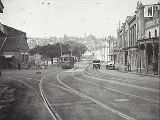 | |
Bayswater Road in Kings Cross in 1929 | |
 | |
A map of Kings Cross, showing the Bayswater Road route | |
| Coordinates |
|
| General information | |
| Type | Street |
| Length | 600 m (0.4 mi)[1] |
| Major junctions | |
| West end | Potts Point (Darlinghurst Road) |
| East end | Darlinghurst (William Street / New South Head Road) |
| Highway system | |
Route
The street's western terminus is located in Potts Point at the junction with Darlinghurst Road. From this point the street heads east over a short rise and down a hill towards Rushcutters Bay where, east of Ward Avenue and west of Roslyn Street, vehicular traffic in the street able to head in one way direction, from west to east only. At Roslyn Street, through traffic is not permitted, with all traffic directed north on Roslyn Street. East of the junction of Roslyn Street and Bayswater Road, southbound traffic on Roslyn Street is also directed one way, east, on Bayswater Road. From this point Bayswater Road merges with William Street and, adjacent to Rushcutters Bay Park, the street continues as New South Head Road.[1]
History
The western end of the street is lined with nightspots, eateries, adult venues, dance clubs hotels, and is a popular destination for both Sydneysiders and tourists. It is considered to be a more upmarket precinct of Kings Cross, when compared with Darlingurst Road.
A busy electric tramway to Watsons Bay once ran down the thoroughfare, this was closed in 1960, replaced by buses.[2]
References
- 1 Bayswater Rd, Potts Point NSW 2011 to 98/96 Bayswater Rd, Darlinghurst NSW 2010 (Map). Google Maps. 2017. Retrieved 15 January 2017.
- Keenan, D. (1979), Tramways of Sydney. Transit Press: Sydney, p. 2