Balmaha
Balmaha (Gaelic: Baile MoThatha) is a village on the eastern shore of Loch Lomond in the council area of Stirling, Scotland.
Balmaha
| |
|---|---|
 The Main Street in Balmaha | |
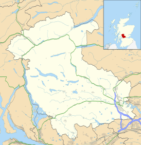 Balmaha Location within the Stirling council area | |
| Population | 60 (approximately) |
| OS grid reference | NS420909 |
| Civil parish | |
| Council area | |
| Lieutenancy area | |
| Country | Scotland |
| Sovereign state | United Kingdom |
| Post town | Glasgow |
| Postcode district | G63 |
| Dialling code | 01360 |
| Police | Scotland |
| Fire | Scottish |
| Ambulance | Scottish |
| UK Parliament | |
| Scottish Parliament | |
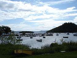
The village is a popular tourist destination for picnickers and day trippers from Glasgow as well as walkers on the West Highland Way. The only road passing through the village is the B837. Boat trips leave from Balmaha for the town of Balloch and the village of Luss as well as nearby Inchcailloch Island.[1]
Balmaha sits at the westerly foot of Conic Hill, and is roughly 30 kilometres (20 miles) along the West Highland Way if coming from Milngavie.
Etymology
The name Balmaha derives from the Gaelic Bealach Mo-Cha, 'the pass of Saint Mo-Cha'. The pass referred to is now named The Pass of Balmaha, a narrow route between hills at the north end of the village, carrying the road north along Loch Lomond. The saint referred to is Kentigerna, patron saint of the parish who was revered especially on the nearby island of Inchcailloch ('Island of Nuns'). Mo-Cha is a 'hypocoristic' form of her name, a sort of devotional nickname, common in medieval Gaelic and Welsh use. She is also commemorated in a well in the hills above the village, St Maha's Well.
Climate
Balmaha has an oceanic climate (Köppen: Cfb). There is a Met Office weather station located at Arrochymore, around 1 km (5⁄8 mi) to the north.
| Climate data for Arrochymore (30 m or 98 ft asl, averages 1981–2010) | |||||||||||||
|---|---|---|---|---|---|---|---|---|---|---|---|---|---|
| Month | Jan | Feb | Mar | Apr | May | Jun | Jul | Aug | Sep | Oct | Nov | Dec | Year |
| Average high °C (°F) | 6.9 (44.4) |
7.2 (45.0) |
9.0 (48.2) |
11.8 (53.2) |
15.1 (59.2) |
17.4 (63.3) |
19.2 (66.6) |
18.8 (65.8) |
16.1 (61.0) |
12.8 (55.0) |
9.5 (49.1) |
7.1 (44.8) |
12.6 (54.6) |
| Average low °C (°F) | 1.2 (34.2) |
1.1 (34.0) |
2.1 (35.8) |
3.5 (38.3) |
6.2 (43.2) |
8.8 (47.8) |
11.0 (51.8) |
10.5 (50.9) |
8.6 (47.5) |
6.1 (43.0) |
3.4 (38.1) |
1.1 (34.0) |
5.3 (41.6) |
| Average rainfall mm (inches) | 211.4 (8.32) |
144.6 (5.69) |
164.6 (6.48) |
90.8 (3.57) |
82.0 (3.23) |
94.3 (3.71) |
106.8 (4.20) |
127.0 (5.00) |
156.8 (6.17) |
193.3 (7.61) |
173.0 (6.81) |
190.9 (7.52) |
1,735.5 (68.31) |
| Average rainy days (≥ 1 mm) | 19.6 | 16.5 | 17.3 | 13.0 | 12.8 | 12.8 | 12.8 | 14.8 | 16.2 | 18.6 | 18.4 | 19.8 | 192.6 |
| Mean monthly sunshine hours | 31.7 | 58.3 | 87.6 | 133.1 | 171.9 | 153.8 | 143.9 | 137.1 | 101.0 | 72.9 | 43.3 | 26.1 | 1,160.7 |
| Source: Met Office[2] | |||||||||||||
Facilities
The village has a visitor centre for the Queen Elizabeth Forest Park.[3] It also has a restaurant and bed and breakfast, the Oak Tree Inn, a bar and a shop. It is also the home of St Mocha coffee shop and ice cream parlour.
The Macfarlane and Son Boatyard is found in Balmaha; the boatyard was established over 150 years ago by John Macfarlane and has been in the family ever since. The boatyard currently runs a ferry service over to Inch Cailloch and around the loch for visitors, as well as delivering the mail to inhabited islands.[4]
Further along the road is Milarrochy Bay.
References
- "Visit Balmaha".
- "Arrochymore (Stirling) UK climate averages". Met Office. Archived from the original on 24 March 2020. Retrieved 24 March 2020.
- "National Park Visitor Centre".
- http://www.balmahaboatyard.co.uk/about.htm
External links
| Wikimedia Commons has media related to Balmaha. |
| Wikivoyage has a travel guide for Balmaha. |