Ballymore (civil parish)
Ballymore (Irish: An Baile Mór)[1] is a civil parish in County Westmeath, Ireland. It is located about 23.57 kilometres (15 mi) west of Mullingar.
Ballymore An Baile Mór | |
|---|---|
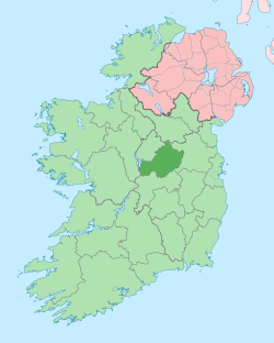
 Ballymore Location of Ballymore within County Westmeath in the Republic of Ireland | |
| Coordinates: 53°29′6″N 7°41′40″W | |
| Country | |
| Province | Leinster |
| County | County Westmeath |
| Irish grid reference | N203483 |
Ballymore is one of 9 civil parishes in the barony of Rathconrath in the Province of Leinster. The civil parish covers 10,434.9 acres (42.229 km2).
Ballymore civil parish comprises the village of Ballymore and 22 townlands: Ballinlig Lower, Ballinlig Upper, Ballymore, Ballynacorra, Ballynafearagh, Calliaghstown, Carricknagower, Cloncullen, Dungolman, Glebe, Harrystown, Lugacaha, Milltown, Moneynamanagh or Umma Beg, Moyvoughly, Mullenmeehan, Newtown, Raheen, Shinglis, Snimnagorta, Toorevagh, Umma Beg or Moneynamanagh and Umma More.
The neighbouring civil parishes are: Forgney and Noughaval (County Longford) to the north, Killare to the east, Ballyloughloe and Kilcumreragh to the south and Drumraney and Noughaval to the west.[1][2][3]
References
- Ballymore civil parish The Placenames Database of Ireland Retrieved on 28 July 2015.
- Ballymore civil parish, Co. Westmeath townlands.ie Retrieved on 31 July 2015.
- Ballymore civil parish, Co. Westmeath The IreAtlas Townland Data Base. Retrieved on 31 July 2015.
External links
- Ballymore civil parish at the IreAtlas Townland Data Base
- Ballymore civil parish at townlands.ie
- Ballymore civil parish at The Placenames Database of Ireland